Near Moran in Teton County, Wyoming — The American West (Mountains)
Leading the Way

Photographed By Barry Swackhamer, May 30, 2016
1. Leading the Way Marker
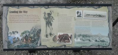
Captions: (top center) Captain William A. Jones; (top right) Togwotee and President Chester Arthur are welcomed at Fort Washakie; (bottom left) Togwotee, for whom this pass is named, attended dances at the Wind River Reservation, and was widely feared for his curses enacted during the Sun Dance (shown above).; (bottom center) Comb made from a sheep's hoof; Family group of a Sheep Eater Band.; (bottom right) Jones' prediction was correct. By 1898, there was an Army wagon road through the pass, By 1922, an auto road had been built, and the pass became an important regional transportation link.
The Tukudiaka were a branch of the Shoshone people known as "Sheep Eaters" for their reliance on the bighorn sheep of the high mountains. They were skilled mountain dwellers, and remained in the mountains after the introduction of the horse.
Among the Tukudika lived a particular man, Togwotee, whose name is said to mean "lance thrower" in the Shoshone language. He was known as an expert marksman and a powerful shaman. Though he spent his youth among the mountains, he later joined the Plains Shoshone on the Wind River Reservation.
An Important Link
In 1873, Togwotee led a mapping expedition under the command of Captain William A. Jones of the United States Army Corps of Engineers, through the pass. The expedition was part of a larger military defense survey.
Jones was impressed with the pass, and with the striking view of the Teton Range. In his report from the expedition, he predicted that the pass would become an important link for commerce between the Atlantic states and the American West.
Ten years after leading Captain Jones through Togwotee Pass, Togwotee led President Chester Arthur from Fort Washakie (now on the Wind River Reservation) through the newly declared Yellowstone National Park.
Erected by Bridger-Teton National Forest.
Topics and series. This historical marker is listed in these topic lists: Exploration • Native Americans • Roads & Vehicles. In addition, it is included in the Former U.S. Presidents: #21 Chester A. Arthur series list.
Location. 43° 45.24′ N, 110° 4.11′ W. Marker is near Moran, Wyoming, in Teton County. Marker is on U. S. Forest Service 30010 (U.S. 287), on the left when traveling west. Touch for map. Marker is in this post office area: Moran WY 83013, United States of America. Touch for directions.
Other nearby markers. At least 3 other markers are within 13 miles of this marker, measured as the crow flies. The Great Divide (about 500 feet away, measured in a direct line); Tie Hack Memorial (approx. 10.3 miles away); Dick Turpin (approx. 12.3 miles away).

Photographed By Barry Swackhamer, May 30, 2016
3. Surrounded by Beauty
Imagine standing here and looking at landscape covered with condominiums and private houses. They do not exist because this land belongs to the public. It is protected.
Just Passing Through
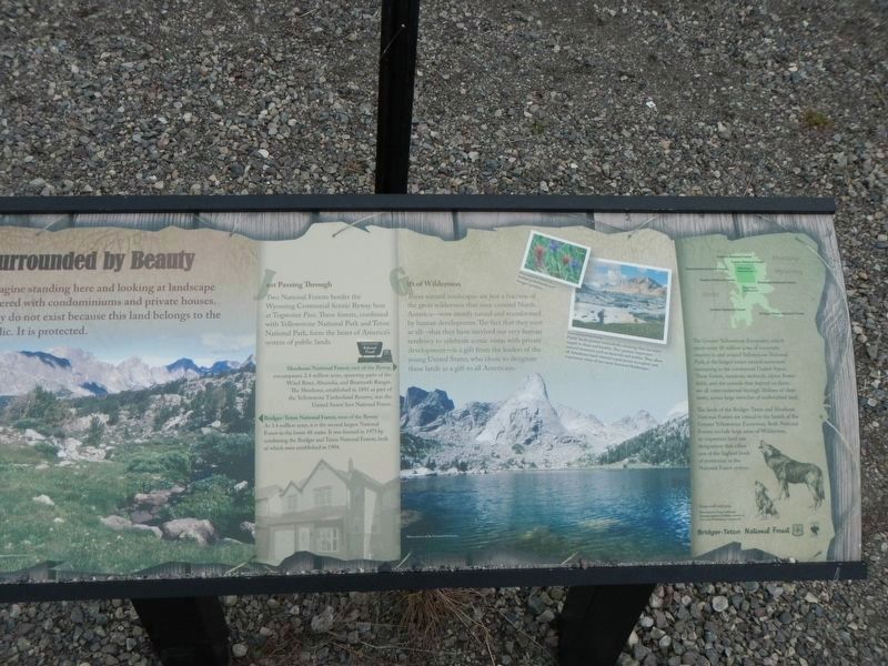
Two National Forests border the Wyoming Centennial Scenic Byway here at Togwotee Pass. These forests, combined with Yellowstone National Park and Teton National Park, form the heart of America's system of public lands.
Shoshone National Forest, east of the Byway, encompasses 2.4 million acres, spanning parts of the Wind River, Absaroka, and Beartooth Ranges. The Shoshone, established in 1891 as part of the Yellowstone Timberland Reserve, was the Unites States' first National Forest.
Bridger-Teton National Forest, west of the Byway. At 3.4 million acres, it is the second largest National Forest in the lower 48 states. It was formed in 1972 by combining the Bridger and Teton National Forests, both of which were established in 1904.
Gift of Wilderness
These natural landscapes are just a fraction of the great wilderness that once covered North America -- now mostly tamed and transformed by human development. The fact that they exist at all - that they have survived our very human tendency to celebrate scenic vistas with private development - is a gift from the leaders of the young United States, who chose to designate these lands as a gift to all Americans.
The Greater Yellowstone Ecosystem, which spans some 18 million acres of mountain country in and around Yellowstone National Park, is the largest intact natural ecosystem remaining in the continental United States. These forests, meadows, wetlands, alpine flower fields, and the animals that depend on them, are all interconnected through lifelines of clean water, across large stretches of undisturbed land.
The lands of the Bridger-Teton and Shoshone National Forests are critical to the health of the Greater Yellowstone Ecosystem. Boat National Forests include large areas of Wilderness, an important land use designation that offers one of the highest levels of protection in the National Forest system.
Captions: (upper right) Indian paintbrush and fringed gentian.; Public lands protect watersheds, ensuring that our water supply is clean and health. They protect important natural resources such as minerals and timber. They allow all Americans (and visitors) equal access to explore and experience some of our most treasured landscapes.; (bottom right) Grey wolf and pup.
Two National Forests border the Wyoming Centennial Scenic Byway here at Togwotee Pass. These forests, combined with Yellowstone National Park and Teton National Park, form the heart of America's system of public lands.
Shoshone National Forest, east of the Byway, encompasses 2.4 million acres, spanning parts of the Wind River, Absaroka, and Beartooth Ranges. The Shoshone, established in 1891 as part of the Yellowstone Timberland Reserve, was the Unites States' first National Forest.
Bridger-Teton National Forest, west of the Byway. At 3.4 million acres, it is the second largest National Forest in the lower 48 states. It was formed in 1972 by combining the Bridger and Teton National Forests, both of which were established in 1904.
These natural landscapes are just a fraction of the great wilderness that once covered North America -- now mostly tamed and transformed by human development. The fact that they exist at all - that they have survived our very human tendency to celebrate scenic vistas with private development - is a gift from the leaders of the young United States, who chose to designate these lands as a gift to all Americans.
The Greater Yellowstone Ecosystem, which spans some 18 million acres of mountain country in and around Yellowstone National Park, is the largest intact natural ecosystem remaining in the continental United States. These forests, meadows, wetlands, alpine flower fields, and the animals that depend on them, are all interconnected through lifelines of clean water, across large stretches of undisturbed land.
The lands of the Bridger-Teton and Shoshone National Forests are critical to the health of the Greater Yellowstone Ecosystem. Boat National Forests include large areas of Wilderness, an important land use designation that offers one of the highest levels of protection in the National Forest system.
Captions: (upper right) Indian paintbrush and fringed gentian.; Public lands protect watersheds, ensuring that our water supply is clean and health. They protect important natural resources such as minerals and timber. They allow all Americans (and visitors) equal access to explore and experience some of our most treasured landscapes.; (bottom right) Grey wolf and pup.
Credits. This page was last revised on August 1, 2016. It was originally submitted on August 1, 2016, by Barry Swackhamer of Brentwood, California. This page has been viewed 467 times since then and 40 times this year. Photos: 1, 2, 3, 4. submitted on August 1, 2016, by Barry Swackhamer of Brentwood, California.

