Near Manassas in Prince William County, Virginia — The American South (Mid-Atlantic)
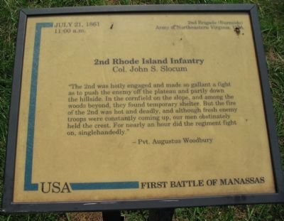
2nd Rhode Island Infantry
— First Battle of Manassas —
11:00 a.m.
2nd Brigade (Burnside)
Army of Northeastern Virginia, USA
Col. John S. Slocum
"The 2nd was hotly engaged and made so gallant a fight as to push the enemy off the plateau and partly down the hillside. In the cornfield on the slope, and among the woods beyond, they found temporary shelter. But the fire of the 2nd was hot and deadly, and although fresh enemy troops were constantly coming up, our men obstinately held the crest. For nearly an hour did the regiment fight on, singlehandedly."
-Pvt. Augustus Woodbury
Topics. This historical marker is listed in this topic list: War, US Civil. A significant historical month for this entry is July 1861.
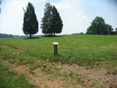
Location. 38° 49.581′ N, 77° 31.89′ W. Marker is near Manassas, Virginia, in Prince William County. Marker can be reached from Sudley Road (State Road 234), on the right when traveling north. Located in the Manassas National Battlefield Park, along the Matthews Hill trail. Touch for map. Marker is in this post office area: Manassas VA 20109, United States of America. Touch for directions.
Other nearby markers. At least 8 other markers are within walking distance of this marker. U.S. Infantry Battalion (about 400 feet away, measured in a direct line); 4th Alabama Infantry (about 400 feet away); The Matthew Farm (about 500 feet away); Rhode Island Battery (about 500 feet away); The Fight for Matthews Hill (about 500 feet away); 2nd New Hampshire Infantry (about 600 feet away); First Contact (about 600 feet away); Matthews Hill (about 700 feet away). Touch for a list and map of all markers in Manassas.
Also see . . . The First Campaign of the 2nd Rhode Island. (Submitted on July 30, 2008, by Craig Swain of Leesburg, Virginia.)
Credits. This page was last revised on June 16, 2016. It was originally submitted on July 30, 2008, by Craig Swain of Leesburg, Virginia. This page has been viewed 1,284 times since then and 25 times this year. Photos: 1, 2, 3. submitted on July 30, 2008, by Craig Swain of Leesburg, Virginia.


