Near St. Mary's City in St. Mary's County, Maryland — The American Northeast (Mid-Atlantic)
Mattapany Street
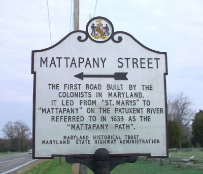
The first road built by the colonists in Maryland. It led from “St. Marys” to “Mattapany” on the Patuxent River. Referred to in 1639 as the “Mattapany Path.”
Erected by the Maryland Historical Trust and the Maryland State Highway Administration.
Topics. This historical marker is listed in these topic lists: Colonial Era • Roads & Vehicles • Settlements & Settlers. A significant historical year for this entry is 1639.
Location. 38° 10.999′ N, 76° 25.618′ W. Marker is near St. Mary's City, Maryland, in St. Mary's County. Marker is at the intersection of Point Lookout Road (Maryland Route 5) and Mattapany Road, on the right when traveling south on Point Lookout Road. Touch for map. Marker is in this post office area: Lexington Park MD 20653, United States of America. Touch for directions.
Other nearby markers. At least 10 other markers are within walking distance of this marker. Finishing the Walls (about 300 feet away, measured in a direct line); Rebuilding a Lost Chapel (about 300 feet away); An Experiment with Liberty of Conscience (about 500 feet away); Sacred Ground and Holy Buildings (about 500 feet away); The Brick Chapel's History (about 500 feet away); Andrew White, Apostle to Maryland (about 500 feet away); Shock Troops of the Counter-Reformation (about 500 feet away); "…buried…in a most solemn manner" (about 500 feet away); Project Lead Coffins (about 500 feet away); Putting Together the Pieces (about 500 feet away). Touch for a list and map of all markers in St. Mary's City.
More about this marker. Arrow on marker points towards Mattapany Road.
Regarding Mattapany Street. Mattapany is an Algonquin Indian word for where a path meets a river, or two rivers meet. Mattapany is now on the Patuxent River Naval Air Station grounds.
Also see . . . History of St. Mary’s County Road Development. St. Mary's County PDF (Submitted on April 26, 2007.)
Credits. This page was last revised on March 6, 2022. It was originally submitted on April 26, 2007, by Tom Fuchs of Greenbelt, Maryland. This page has been viewed 2,341 times since then and 56 times this year. Photos: 1. submitted on April 26, 2007, by Tom Fuchs of Greenbelt, Maryland. 2. submitted on July 8, 2008, by Tom Fuchs of Greenbelt, Maryland. • J. J. Prats was the editor who published this page.
Editor’s want-list for this marker. Interesting views on Mattapany Road. • Can you help?

