Cleveland in White County, Georgia — The American South (South Atlantic)
Discovery of Gold
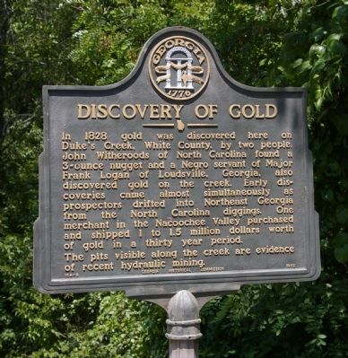
Photographed by David Seibert, August 3, 2008
1. Discovery of Gold Marker
Erected 1962 by Georgia Historical Commission. (Marker Number 154-9.)
Topics and series. This historical marker is listed in these topic lists: Industry & Commerce • Waterways & Vessels. In addition, it is included in the Georgia Historical Society series list. A significant historical year for this entry is 1828.
Location. 34° 40.25′ N, 83° 42.833′ W. Marker is in Cleveland, Georgia, in White County. It is on Helen Highway (State Highway 75) 0.6 miles Duncan Bridge Road (State Route 384), on the right when traveling north. The marker is on a small unnamed private
this page online

Regionally, this marker is in the Mountains. It is also in the American South, specifically in the Deep South, in Appalachia, and specifically in Southern Appalachia. Globally, it is in North America, the Western Hemisphere, the Western World, and the Anglosphere. Historically, it finds itself in what was once the original Cherokee Nation, the territory of the Mississippian Culture, one of the original Thirteen Colonies, one of the Confederate States of America, and the Antebellum South.
Other nearby markers. At least 8 other markers are within one mile of this marker, measured as the crow flies: Nacoochee Indian Mound (approx. one mile away); Nacoochee Mound (approx. one mile away); The Residence at West End (approx. one mile away); Fountain and Greenhouse (approx. one mile away); a different marker also named The Residence at West End (approx. one mile away); The Game Room (approx. one mile away); Domestic Life at the Farm (approx. 1.1 miles away); Breezeway,Smokehouse/Servant's Quarters & Kitchen (approx. 1.1 miles away).
Credits. This page was last revised on February 1, 2020. It was originally submitted on August 7, 2008, by David Seibert of Sandy Springs, Georgia. This page has been viewed 2,317 times since then and 59 times this year. Photo 1. submitted on August 7, 2008, by David Seibert of Sandy Springs, Georgia. • Kevin W. was the editor who published this page.
Editor’s want-list for this marker. Wide area picture of the marker and its surroundings. • Can you help?
