Villa Rica in Carroll County, Georgia — The American South (South Atlantic)
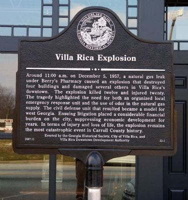
Villa Rica Explosion
Erected 2007 by Georgia Historical Society, City of Villa Rica, and Villa Rica Downtown Development Authority. (Marker Number 22-1.)
Topics and series. This historical marker is listed in these topic lists: Disasters • Industry & Commerce • Science & Medicine. In addition, it is included in the Georgia Historical Society series list. A significant historical date for this entry is December 5, 1927.
Location. 33° 43.895′ N, 84° 55.178′ W. Marker is in Villa Rica, Georgia, in Carroll County. Marker is at the intersection of Bankhead Highway (U.S. 78) and South Candler Street, on the left when traveling west on Bankhead Highway. Touch for map. Marker is at or near this postal address: 130 Montgomery Street, Villa Rica GA 30180, United States of America. Touch for directions.
Other nearby markers. At least 8 other markers are within 4 miles of this marker, measured as the crow flies. Bank of Villa Rica (within shouting distance of this marker); Villa Rica's Textile Industry (within shouting distance of this marker); Freedom Riders (about 400 feet away, measured in a direct line); The Mill (about 500 feet away); Thomas Andrew Dorsey (about 500 feet away); Thomas A. Dorsey (approx. 0.4 miles away); Fullerville Jail (approx. one mile away); The Grove (approx. 3½ miles away). Touch for a list and map of all markers in Villa Rica.
Credits. This page was last revised on January 3, 2020. It was originally submitted on August 7, 2008, by David Seibert of Sandy Springs, Georgia. This page has been viewed 1,699 times since then and 34 times this year. Photo 1. submitted on August 7, 2008, by David Seibert of Sandy Springs, Georgia. • Kevin W. was the editor who published this page.
Editor’s want-list for this marker. A wide shot of the marker and its surroundings. • Can you help?
