Mount Jewett in McKean County, Pennsylvania — The American Northeast (Mid-Atlantic)
Kinzua Bridge
The Life, Death and Renewal
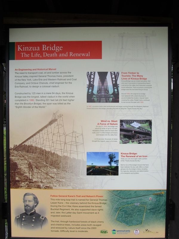
An Engineering and Historical Marvel. The need to transport coal, oil and lumber across the Kinzua Valley inspired General Thomas Kane, president of the New York, Lake Erie and Western railroad and Coal Company, and Octave Chanute, chief engineer for the Erie Railroad, to design a colossal viaduct.
Constructed by 125 men in a mere 24 days, the Kinzua Bridge was the tallest viaduct in the world when completed in 1882. Standing 301 feet tall (24 feet higher that the Brooklyn Bridge), the span was billed as the "Eighth Wonder of the World."
From Timber to Tourists: The Many Lives of Kinzua Bridge. Kinzua Bridge was an instant sensation. Not only was it successful in transporting Kane's coal across the valley, but it became a popular tourist attraction. Train excursions crossing the bridge were the next best thing to flying!
Around 1900, the original iron bridge was replaced with a steel structure to accommodate the modern heavier trains crossing the valley. Freight trains continued to roar across the span until 1959.
In 1987, excursion trains were reintroduced and began running through the Allegheny National Forest and across the bridge, providing the thrill of riding the "Tracks Across the Sky."
In 30 seconds, the power of nature brought the majestic span to its knees.
Kinzua Bridge: The Renewal of an Icon. Today you can once again walk a portion of the "Tracks Across the Sky."
Built on six of the bridge's towers that have been restored, the sky walk offers a unique glimpse into the bridge's history revealing the ingenuity, dedication and determination of its designers and builders.
Follow General Kane's Trail and Nature's Power. This mile-long loop trail is named for General Thomas Leiper Kane - the visionary behind the Kinzua Bridge. During the Civil War, Kane assembled the famed Bucktail Regiment. He also supported slave rights and, later, the Latter-day Saint movement as it migrated westward.
The trail, through hardwood forests of black cherry and chestnut trees, includes areas both ravaged and renewed by nature itself since the 2003 tornado. Difficulty level is moderate.
Erected by Allegheny National Forests, Pennsylvania Department of Conservation and Natural Resouces, Pennsylvania Wilds.
Topics. This historical marker is listed in these topic lists: Bridges & Viaducts • Entertainment
• Railroads & Streetcars • War, US Civil. A significant historical date for this entry is July 21, 2003.
Location. 41° 45.528′ N, 78° 35.17′ W. Marker is in Mount Jewett, Pennsylvania, in McKean County. Marker can be reached from Viaduct Road, one mile north of Lindholm Road (Pennsylvania Route 3011). Touch for map. Marker is at or near this postal address: 296 Viaduct Road, Mount Jewett PA 16740, United States of America. Touch for directions.
Other nearby markers. At least 8 other markers are within 8 miles of this marker, measured as the crow flies. Kinzua Viaduct (about 300 feet away, measured in a direct line); Spanning History (about 400 feet away); Sites to See (about 500 feet away); Commerce to Collapse (about 600 feet away); Forces of Nature (about 700 feet away); Nebo Lutheran Chapel and Cemetery (approx. 4.4 miles away); Great Events in Smethport History (approx. 7.9 miles away); a different marker also named Great Events in Smethport History (approx. 7.9 miles away). Touch for a list and map of all markers in Mount Jewett.
Credits. This page was last revised on July 2, 2017. It was originally submitted on July 2, 2017, by Anton Schwarzmueller of Wilson, New York. This page has been viewed 339 times since then and 13 times this year. Photos: 1, 2. submitted on July 2, 2017, by Anton Schwarzmueller of Wilson, New York.

