Donalds in Abbeville County, South Carolina — The American South (South Atlantic)
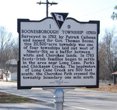
Boonesborough Township (1763)
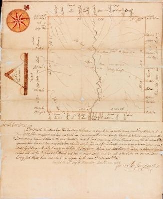
Surveyed in 1762 by Patrick Calhoun and named for Gov. Thomas Boone, this 20,500-acre township was one of four townships laid out west of Ninety-Six as a buffer between white and Cherokee lands. In 1763 Scots-Irish families began to settle in the area near Long Cane, Park's and Chickasaw Creeks. The headwaters of Long Cane Creek are 500 feet south; the Cherokee Path crossed the township boundary one mile south.
Erected 1996 by Donalds Historical Society. (Marker Number 1-9.)
Topics. This historical marker is listed in these topic lists: Colonial Era • Political Subdivisions • Settlements & Settlers. A significant historical year for this entry is 1762.
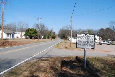
Location. 34° 22.317′ N, 82° 21.014′ W. Marker is in Donalds, South Carolina, in Abbeville County. Marker is on West Main Street (State Highway 184) north of Brooks Lane, on the left when traveling south. Touch for map. Marker is in this post office area: Donalds SC 29638, United States of America. Touch for directions.
Other nearby markers. At least 10 other markers are within 4 miles of this marker, measured as the crow flies. Templeton-Drake Cabin ca. 1764 (approx. ¼ mile away); The Donalds Grange No. 497 (approx. 0.3 miles away); Greenville Presbyterian Church (approx. 3.1 miles away); Due West (approx. 3.3 miles away); Rev. J.I. Bonner Monument (approx. 3.4 miles away); Angela Marlow Newton (approx. 3.4 miles away); Erskine College (approx. 3.6 miles away); Abbeville County (approx. 3.6 miles away); Bryson College Memorial (approx. 3.6 miles away); William Moffatt Grier (approx. 3.6 miles away). Touch for a list and map of all markers in Donalds.
Regarding Boonesborough Township (1763). Boonesborough Township never actually developed into a township as the name implies. The towns of Donalds and Due West eventually became established in the area. Donalds formed in 1842 and is located on what was the north corner of Boonesborough. Due West became a town in the western corner of Boonesborough. (Source: http://web.infoave.net/~kfleming/bhs.html.)
Also see . . .
1. The Royal Colony of South Carolina - The Township Acts of 1730 and 1761. There are many contradicting histories on what really led to the establishment of "Townships" in the interior of South Carolina immediately after the Crown took over the colony in 1729. (Submitted on November 14, 2008, by Brian Scott of Anderson, South Carolina.)
2. The Royal Colony of South Carolina - Overview of the Colony
. Overview of South Carolina's royal period, including a discussion of the township program of which Boonesborough was a part. (Submitted on November 14, 2008, by Brian Scott of Anderson, South Carolina.)
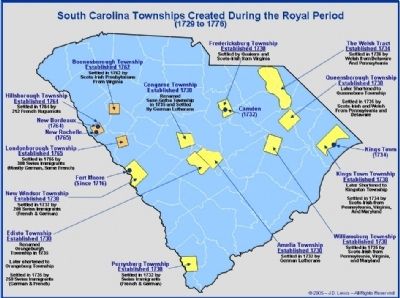
3. 12 Townships and a large unsurveyed tract were established in South Carolina - 1730 to 1761. Map of the Royal Townships of South Carolina. (Submitted on November 14, 2008, by Brian Scott of Anderson, South Carolina.)
4. Boonesborough Township Original Settlers. List of the 70 original settlers of Boonesborough Township. (Submitted on January 25, 2009, by Brian Scott of Anderson, South Carolina.)
5. Thomas Boone. Thomas Boone was the 7th Royal Governor of New Jersey (after the position became solely "Governor of New Jersey") and the 28th Royal Governor of South Carolina. (Submitted on August 22, 2008, by Brian Scott of Anderson, South Carolina.)
6. Drake Family Members Who Lived in the Cabin. RootsWeb posting listing the Drake family members who lived in the cabin. (Submitted on August 22, 2008, by Brian Scott of Anderson, South Carolina.)
7. The Drakes of Abbeville Co, SC. Nancy Agnes Brackenridge and James Drake Jas. Drake b. 1 Jan 1784, d. 7 Dec 1854. Nancy Brackenridge (or Breckenridge) b. 30 Oct 1786 d. 2 Nov 1857. m. 26 Sep 1804 at Greenville (Greenvale) Presbyterian Ch. in Abbeville District, South Carolina. (Submitted on November 21, 2009, by Brian Scott of Anderson, South Carolina.)
8. The Boonesborough Historical Society. Originally the Donalds Historical Society, growth and expanded membership were behind the name change to the Boonesborough Historical Society. (Submitted on August 22, 2008, by Brian Scott of Anderson, South Carolina.)
9. Donalds, South Carolina. Donalds is a town in Abbeville County, South Carolina, United States. (Submitted on January 25, 2009, by Brian Scott of Anderson, South Carolina.)
10. Due West, South Carolina. Due West is a town in Abbeville County, South Carolina, United States. (Submitted on November 21, 2009, by Brian Scott of Anderson, South Carolina.)
Additional commentary.
1. Buffer Townships
According to the marker, Boonesborough was one of four townships established west of Ninety Six as buffers between the Cherokee and English settlements. The other three were named Hillsborough (settled by French Huguenots), Londonborough (Dutch Lutherans), and New Windsor (Germans). According to historian Walter B. Edgar, Boonesborough Township was established specifically for Irish immigrants. (Source: South Carolina: A History by Walter B. Edgar.)
— Submitted January 25, 2009, by Brian Scott of Anderson, South Carolina.
2. Marker Style
The marker shown reflects the second style of South Carolina Historical Markers. It was in use between 1955 and 1990. The original design was cast aluminum and crowned with a bas relief of the state flag surrounded by an inverted triangle. The markers were painted dark blue with silver lettering.
— Submitted September 16, 2008, by Brian Scott of Anderson, South Carolina.
3. Patrick Calhoun, the First Lawmaker from the Upper Country
Patrick Calhoun — We have now seen the men who were leaders in the work of making settlements near the seacoast of South Carolina. We have followed some of the settlers as they made their way from the seashore up the four great rivers, the Savannah, the Edisto, the Santee, and the Pee Dee.
We must now turn our eyes to the northern border of the colony to watch the coming of a great multitude of settlers from Scotland. Among these new colonists we shall see a strong, brave man leading the rest of his people in the work of building homes in the highlands. This man is Patrick Calhoun, the father of the great and good South Carolina statesman, John C. Calhoun.
Scotch Emigrants to the Upper Country — Patrick Calhoun was a Scot, a descendant of that large body of people who left the lowlands of Scotland and crossed over to Ireland, where they were called Scotch-Irish. Then they sailed across the Atlantic to Pennsylvania. Some of them made their way southward from Pennsylvania through Virginia into the Carolinas. The journey through the forests was long and weary. The women and children were borne along in carts. The men walked in advance, some with rifles and some with axes. Each night the company of pilgrims went into camp. Around the great camp fire they sang some of the Psalms of David and prayed for God's guidance and protection. At last the Calhouns and other Scots came to the upper country of South Carolina.
Long Canes Settlement — In February, 1756, Patrick Calhoun led a small group of Scots with their families into the region west of the Saluda River. The land near the creeks and rivulets was covered with wild cane from five to thirty feet in height. They built homes on Long Cane Creek, in the present Abbeville County. Their community was named the Long Canes settlement. In the year 1760 some Indians attacked this settlement and killed a number of the colonists. The rest fled, and among the number, Patrick Calhoun. Afterwards he returned to the country of the cane brakes, in Abbeville.
The Waxhaws Settlement — About the year 1760 a company of Scots Cut down the trees and built
log cabins in the district known as the Waxhaws settlement. These early settlers wore buckskin breeches and woolen hunting-shirts. They had caps made of raccoon skins, with the tail of the animal hanging from the back part of the cap. They were good marksmen, and then- rifles brought down game at long range. They built their log houses near the rivers and creeks, and the first season after their arrival a crop of corn was grown.
The stream of Scots from the northward kept on bringing settlers to the Waxhaws. A log church was built. The earth was the only floor and the seats were made of split logs. The people of the settlement came together in this building every Sunday to worship God according to the Presbyterian form of service.
The Settlement of Lancaster County —Through the Waxhaws settlement the stream of settlers poured into the region now called Lancaster County. Then they crossed the Catawba and found the hills and ridges covered with forests of hickory, chestnut, and oak. The ground in the woodlands was hidden under a carpet of wild-pea vines and wild flowers. This fair region of forest and vine and flowing stream was the home of vast numbers of buffaloes, deer, bear, turkeys, partridges, geese, and ducks. The Scots made it their own home and their habitations remain in this earthly paradise, until this day. From the Catawba region they passed
across to the headwaters of the Broad and Saluda. One of the early settlers on Tyger River in the present Spartanburg County was Anthony Hampton from whom sprang all the great soldiers bearing the name of Hampton in South Carolina.
Other Settlements in the Upper Country — About 1765, as captain of the armed men of the settlement, Patrick Calhoun marched some distance down the Saluda to meet and offer welcome to two bodies of settlers who entered the colony at Charles Town. One of these was made up of Germans, who settled on Hard Labor Creek, in Abbeville County. The other company was a group of Huguenot families, who established themselves near Long Canes. The Calhouns furnished them for a time with food. The Huguenots called their settlements New Bordeaux and New Rochelle, and afterward they gave to the county the French name, Abbeville. Just before the outbreak of the Revolution some Scots sailed to Charles Town Harbor and then moved into the highlands to join the other Scots who were moving southward from Pennsylvania and Virginia. These Scots took possession of nearly all of the upper country of South Carolina. They were intelligent people, and worked with great energy. They killed the wild beasts, drove away the Indians, cut down the forests, and planted corn and wheat. They built churches and schoolhouses. Their ministers were well- educated men, and
the people themselves had a good knowledge of the Bible.
Patrick Calhoun Admitted to the South Carolina Legislature -— In 1768 Patrick Calhoun, with a few others, presented himself before the legislature at Charles Town and asked the rulers of the colony to show more justice to the settlers in the highlands. These settlers wished the same privileges that were given to other tax-payers. They asked the lawmakers to open public roads, to organize courts of justice, to allow the upper country to send delegates to the legislature, and to help the mountaineers as they helped the lowlanders to build schoolhouses and churches and to secure ministers. In the following year (1769) Patrick Calhoun took his seat among the lawmakers at Charles Town as the first representative chosen by the people of the upper country. Patrick Calhoun's last wife was the daughter of John Caldwell, a Scot who joined the settlement in Abbeville. Their son was John Caldwell Calhoun, South Carolina's great lawgiver. (Source: The Making of South Carolina by Henry Alexander White, pgs 62-67.)
— Submitted November 4, 2010, by Brian Scott of Anderson, South Carolina.
Photographed By Brian Scott, February 16, 2003
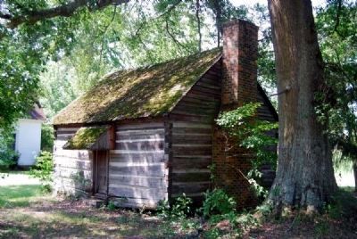
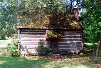
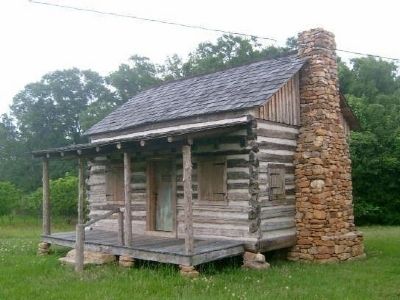
9. Templeton-Drake Cabin (ca. 1764) -
Only Surviving Structure from Boonesborough Township
Only Surviving Structure from Boonesborough Township
Dedicated to Jane Byrd Wilson (Sept. 19,1939 - March 17, 2000). She worked to preserve the valuable heritage of the Boonesborough Township.
Click for more information.
Click for more information.
Credits. This page was last revised on May 5, 2019. It was originally submitted on April 16, 2008, by Brian Scott of Anderson, South Carolina. This page has been viewed 5,459 times since then and 85 times this year. Last updated on August 22, 2008, by Brian Scott of Anderson, South Carolina. Photos: 1. submitted on November 21, 2009, by Brian Scott of Anderson, South Carolina. 2. submitted on January 25, 2009, by Brian Scott of Anderson, South Carolina. 3. submitted on April 17, 2008, by Brian Scott of Anderson, South Carolina. 4. submitted on November 21, 2009, by Brian Scott of Anderson, South Carolina. 5. submitted on May 20, 2012, by Brian Scott of Anderson, South Carolina. 6, 7, 8. submitted on November 4, 2010, by Brian Scott of Anderson, South Carolina. 9. submitted on July 30, 2008, by Brian Scott of Anderson, South Carolina. 10. submitted on October 5, 2008, by Brian Scott of Anderson, South Carolina. 11. submitted on November 4, 2010, by Brian Scott of Anderson, South Carolina. 12. submitted on May 21, 2012, by Brian Scott of Anderson, South Carolina. 13. submitted on May 20, 2012, by Brian Scott of Anderson, South Carolina. 14. submitted on May 21, 2012, by Brian Scott of Anderson, South Carolina. 15. submitted on May 20, 2012, by Brian Scott of Anderson, South Carolina. 16. submitted on May 21, 2012, by Brian Scott of Anderson, South Carolina. 17. submitted on May 20, 2012, by Brian Scott of Anderson, South Carolina. 18, 19, 20, 21. submitted on May 21, 2012, by Brian Scott of Anderson, South Carolina. • Kevin W. was the editor who published this page.
