Natchitoches in Natchitoches Parish, Louisiana — The American South (West South Central)
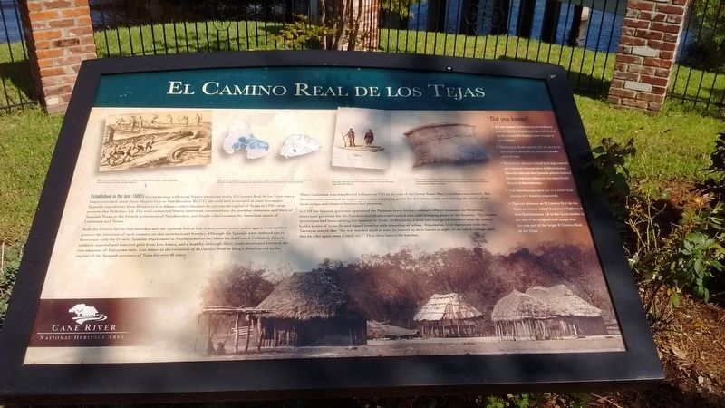
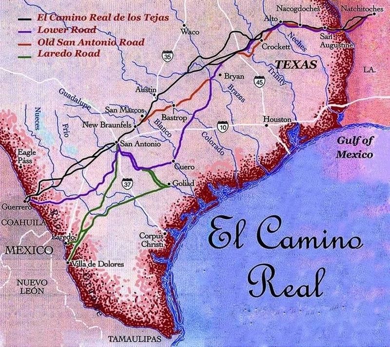
El Camino Real de los Tejas
Both the French fort at Natchitoches and Spanish fort at Los Adaes, some twelve miles apart, were built to protect the interests of each country on this international frontier. Although the Spanish were ordered not to fraternize with the French, Spanish friars came to Natchitoches to say Mass for the French Catholics, French soldiers courted and married girls from Los Adaes, and an healthy, although illicit, trace developed between the two outposts of European rule. Los Adaes at the terminus of El Camino Real or King’s Road served as the capital of the Spanish province of Tejas for over 40 years.
When Louisiana was transferred to Spain in 1762 at the end of the Seven Years War, Los Adaes was closed. But Natchitoches remained an important center supplying goods for the Indian trade and service the needs of the local indigo and tobacco farmers and planters.
In 1769 the Spanish governor appointed the Parisian-born, former military office Athanase de Mezieres, lieutenant governor for the Natchitoches district and tasked him with bringing peace to the frontiers. The Native Americans had been raiding the Spanish in Texas. DeMezieres, a man who had good relations with the tribes, held a series of councils and signed treaties with a number of tribes. Stipulation 11 of the treaty with the Taovayas stated that “the war hatchet shall at once be buried by their hands in sight of the whole village, and that he who again uses it shall die.” They then buried the hatchet.
(sidebar)
Did you know?
• Did you know? Archaeological evidence proves that the French and Spanish traded goods across the frontier even though it was illegal.
• That France, Spain, and the U.S. all owned or laid claim to this part of Louisiana at one point in time.
• The Catholic Church helped to bridge cultural and national interest here in Natchitoches. Records indicate that Spanish priests walked 22 miles from Los Adaes to say mass for the French of Natchitoches.
• The Natchitoches meat pie is a white flour version of a Spanish empanada.
• That our reliance on El Camino Real de los Tejas continues today? Louisiana highway 6 from Natchitoches, LA to the Texas border is one of the original trail routes that became part of the larger El Camino Real de los Tejas.
Topics. This historical marker is listed in these topic lists: Colonial Era • Forts and Castles • Roads & Vehicles. A significant historical year for this entry is 1717.
Location. 31° 45.258′ N, 93° 5.225′ W. Marker is in Natchitoches, Louisiana, in Natchitoches Parish. Marker is at the intersection of Jefferson Street (State Highway 6) and Keyser Avenue (State Highway 494), on the right when traveling north on Jefferson Street. Touch for map. Marker is in this post office area: Natchitoches LA 71457, United States of America. Touch for directions.
Other nearby markers. At least 8 other markers are within walking distance of this marker. Natchitoches and the Early American Period (a few steps from this marker); Dr. John Sibley (a few steps from this marker); Bayou Amulet (approx. 0.2 miles away); The Jefferson Highway (approx. 0.2 miles away); The American Cemetery (approx. ¼ mile away); Fort Saint Jean Baptiste (approx. ¼ mile away); a different marker also named The American Cemetery (approx. ¼ mile away); Fort St. Jean Baptiste (approx. ¼ mile away). Touch for a list and map of all markers in Natchitoches.
Also see . . . The History of El Camino Real de los Tejas. (Submitted on July 26, 2017, by Tom Bosse of Jefferson City, Tennessee.)
Credits. This page was last revised on July 27, 2017. It was originally submitted on July 26, 2017, by Tom Bosse of Jefferson City, Tennessee. This page has been viewed 445 times since then and 28 times this year. Photos: 1, 2, 3. submitted on July 26, 2017, by Tom Bosse of Jefferson City, Tennessee. • Bernard Fisher was the editor who published this page.


