Beatty in Nye County, Nevada — The American Mountains (Southwest)
Desert Hills Cemetery
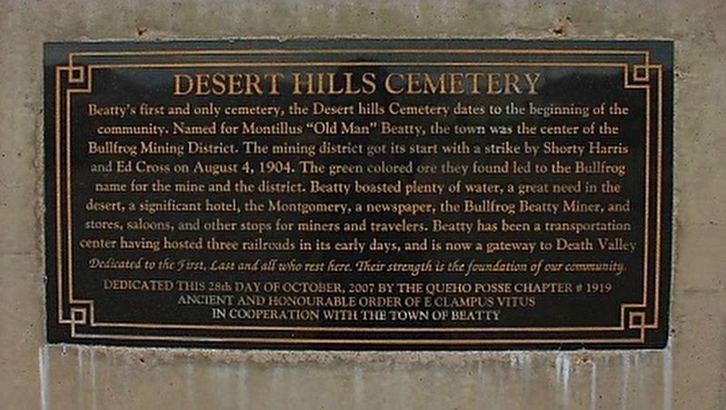
Photographed by Queho Posse Chapter 1919 E Clampus Vitus
1. Desert Hills Cemetery Marker
Erected 2007 by Queho Posse Chapter # 1919 of the Ancient and Honorable Order of E Clampus Vitus In Cooperation with the town of Beatty.
Topics and series. This historical marker is listed in this topic list: Cemeteries & Burial Sites. In addition, it is included in the E Clampus Vitus series list. A significant historical date for this entry is August 4, 1904.
Location. 36° 53.977′ N,
this page online

Regionally, this marker is in the Mojave Desert and in Central Nevada. It is also in the American Southwest and in the Mountain West. Globally, it is in North America, the Western Hemisphere, the Western World, and the Anglosphere. Historically, it finds itself in what was once New Spain and also Mexico’s Alta California.
Other nearby markers. At least 8 other markers are within 4 miles of this marker, measured as the crow flies: 1921 Fordson Tractor (approx. 0.4 miles away); Beatty (approx. half a mile away); Mona Bell's Grave (approx. 3.6 miles away); Miner's Cabin (approx. 3.6 miles away); Rhyolite Jail (approx. 3.6 miles away); Red-Light District (approx. 3.6 miles away); Adobe Dance Hall (approx. 3.7 miles away); Rhyolite (approx. 3.7 miles away). Touch for a list and map of all markers in Beatty.

2. Desert Hills Cemetery and Marker
Credits. This page was last revised on November 21, 2024. It was originally submitted on August 14, 2017, by Frank Gunshow Sanchez of Hollister, California. This page has been viewed 781 times since then and 49 times this year. Photos: 1, 2. submitted on August 14, 2017. • Syd Whittle was the editor who published this page.
