North Capitol in Nashville in Davidson County, Tennessee — The American South (East South Central)
An Urban Greenway
Along Nashville's Historic
— Downtown Riverfront —
Side 1
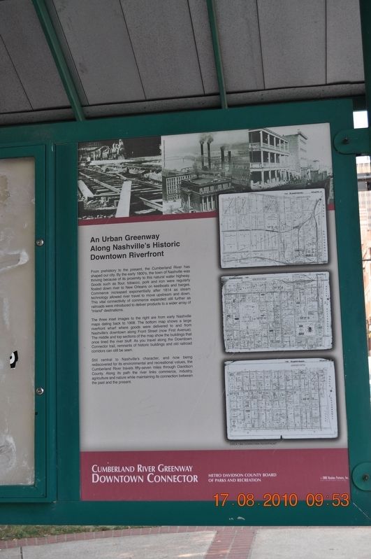
From prehistory to the present, the Cumberland River has shaped our city. By the early 1800's, the town of Nashville was thriving because of its proximity to this natural water highway. Goods such as flour, tobacco, pork and iron were regularly floated down river to New Orleans on keelboats and barges. Commerce increased exponentially after 1814 as steam technology allowed river travel to move upstream and down. This vital connectivity of commerce expanded still further as railroads were introduced to deliver products to a wider array of "inland" destinations.''
The three inset images to the right are from early Nashville map dating back toy 1908. The bottom map shows a large riverfront wharf where delivered to and from Nashville's downtown along Front Street (now First Avenue). The middle and top sections of the map show the buildings that once lined the river bluff. As you travel along the Downtown Connector trail, remnants of historic buildings and old railroad corridors can still be seen.
Still central to Nashville's character, and now being rediscovered for its environmental and recreational values, the Cumberland River travel fifty-seven miles through Davidson County. Along its path the river links commerce, industry, agriculture and nature while maintaining its connecting between the past and the present.
Side 2
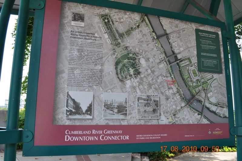
This greenway trail is a short segment in a growing network of multi-use trails and linear parks throughout the city. This segment, the Downtown Connector, is unique in its historical context and urban character.
The city of Nashville was born on these riverbanks. The bluff location offered early settlers protection from enemies, and the river itself provided water for survival and corridor for transportation. As the city developed through the nineteenth and twenieth centuries, many brick and stone buildings were constructed along Front Street (now First Avenue) and backed up to the bluff's edge. Brick inlays along the trail from the "footprint" of some of these now-gone structures.
During the 1970's, the bluff was transformed by the development of Riverfront Park and the Gay Street Connector. From here at historic Fort Nashboro, the Downtown Connector leads northwestward along the west bank of the Cumberland connecting many nearby point of interest including the Timothy Demonbreum statue, the historic Woodland Street Bridge, the Cherokee Nation Trail of Tears, and an historic train trestle. The trail then turns inland and leads to the French Lick Greenway, Tennessee Bicentennial Mall and Farmers Market.
Help Protect the Park
Please Follow These Rules
This is a Multi-Purpose Trail
• keep to the right, pass to the left • keep pets on a leash not exceeding six feet • put litter in its place
Cyclists Have Special Responsibilities
• keep speed moderate and maintain control • pass on the left and give audible signals • yield to pedestrians
Drugs and Alcohol are prohibited
Motorized vehicles are prohibited
Safety is our highest priority
• exercise caution at street crossings
• enjoy the greenway with a friend
• leave valuables at home
• take your car keys with you
Photos
Public Square, 1935
Tennessee State Library Archives
Typical Downtown Street, 1880
Tennessee State Library Archives
The Nashville Wharf, 1890s
Tennessee State Library Archives
Public Square, 1935
Tennessee State Library Archives
Erected by Metro Davidson County Board of Parks and Recreation.
Topics. This historical marker is listed in these topic lists: Entertainment • Environment • Settlements & Settlers. A significant historical year for this entry is 1908.
Location. 36° 10.229′ N, 86° 46.728′ W. Marker is in Nashville, Tennessee, in Davidson County. It is in North Capitol. Marker is on Cumberland River Greenway. Touch for map. Marker is at or near this postal address: First Avenue, Nashville TN 37201, United States of America. Touch for directions.
Other nearby markers. At least 8 other markers are within walking distance of this marker. Site of Original Gas Works (about 700 feet away, measured in a direct line); Houston's Law Office (about 800 feet away); On This Site Stood the Nashville Inn (approx. 0.2 miles away); Nashville Inn (approx. 0.2 miles away); First Bridge Over the Cumberland (approx. 0.2 miles away); Victory Memorial Bridge (approx. 0.2 miles away); Journey West: Forced Removal of the Cherokee (approx. 0.2 miles away); April 19, 1960 (approx. ¼ mile away). Touch for a list and map of all markers in Nashville.
Credits. This page was last revised on February 7, 2023. It was originally submitted on August 30, 2017, by Sandra Hughes Tidwell of Killen, Alabama, USA. This page has been viewed 287 times since then and 6 times this year. Photos: 1, 2. submitted on August 30, 2017, by Sandra Hughes Tidwell of Killen, Alabama, USA. • Bill Pfingsten was the editor who published this page.

