Littlestown in Adams County, Pennsylvania — The American Northeast (Mid-Atlantic)
Littlestown
And the Civil War
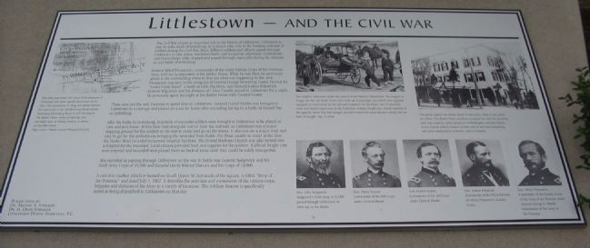
General Alfred Pleasanton, commander of the entire Cavalry Corps of the Potomac Army, held his headquarters at the Barker House. While he was there he sent many scouts to the surrounding towns to find out what was happening in the area. Pleasanton was seen in the company of General George Armstrong Custer, famous for "Custer's Last Stand" a battle at Little Big Horn, and General Judson Kilpatrick. General Kilpatrick and his Division of Union Cavalry stayed in Littlestown for a night. He personally spent the night at the Barker House with General Custer.
These were not the only Generals to spend time in Littlestown. General Daniel Sickles was brought to Littlestown in a carriage and placed on a car for home after wounding his leg in a battle at Round Top in Gettysburg.
After the battle in Gettysburg, hundreds of wounded soldiers were brought to Littlestown to be placed in cars and sent home. At this time Gettysburg did not yet have the railroad, so Littlestown was a major stopping ground for the soldiers in the war to come and go on the trains. It also was on a major road and easy to get for the ambulances bringing the wounded from battle. For those unable to travel at the time the Barker Hotel provided temporary hospital facilities. The United Brethren Church was also turned into a hospital for the wounded. Local citizens provided food and supplies for the soldiers. Railroad freight cars were emptied and wounded were placed there on beds of straw until they could be safely transported.
Also recorded as passing through Littlestown on the way to battle was General Sedgewick and his Sixth Army Corps of 15,000 and General Henry Warner Slocum and his Corps of 13,000.
A cast iron marker, which is located on South Queen St. just south of the square, it titled "Army of the Potomac" and dated July 5, 1862. It describes the activities and movements of the various corps, brigades and divisions of the Army to a variety of locations. The Artillery Reserve is specifically noted as being dispatched to Littlestown on that day.
Topics. This historical marker is listed in this topic list: War, US Civil. A significant historical date for this entry is July 5, 1747.
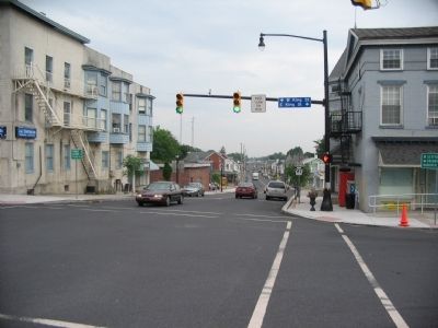
Location. 39° 44.681′ N, 77° 5.281′ W. Marker is in Littlestown, Pennsylvania
, in Adams County. Marker is at the intersection of Queen Street (State Highway 97) and King Street (State Highway 194), on the right when traveling north on Queen Street. Touch for map. Marker is in this post office area: Littlestown PA 17340, United States of America. Touch for directions.
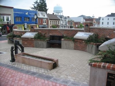
Other nearby markers. At least 8 other markers are within walking distance of this marker. Littlestown 250 Years (here, next to this marker); a different marker also named Littlestown (here, next to this marker); a different marker also named Littlestown (here, next to this marker); a different marker also named Littlestown (here, next to this marker); Peter (Klein) Little (here, next to this marker); a different marker also named Littlestown (a few steps from this marker); Littlestown War Memorial (within shouting distance of this marker); Army of the Potomac (about 300 feet away, measured in a direct line). Touch for a list and map of all markers in Littlestown.
More about this marker. On the left, This 1858 map shows the extent of development of Littlestown and notes specific businesses of the time. The intersection of King and Queen Streets. The crossroads of the Old Monocacy Road and the Gettysburg-Petersburg Road, is well developed. The Barker Hotel, scene of meetings and overnight stays of military leaders, is shown on the NW corner.
In the upper center an illustration shows The hospital trains were under the control of the Medical Department.
The surgeon in charge was the sole head. Some were made up of passenger cars which were regularly equipped or constructed by the railroad companies for the better care of wounded, some were hastily improvised at the front from ordinary freight cars, merely emptied of the supplies which they had brought up and in which the wounded were merely laid on beds of boughs, hay, or straw.
In the upper right, This photo depicts the Barker Hotel in later years, when it was called the Ocker. The Barker Hotel served as a hospital for the civil war wounded, until they could be safely moved on to Washington and their homes. It also housed military leaders on their way to and from Gettysburg and other nearby battle locations, such as Hanover.
Portraits of Generals Sedgewick, Slocum, Sickles, Kilpatrick, and Pleasanton are across the bottom of the marker.
Also see . . . Littlestown in the Civil War. Article from the Littlestown Area Historical Society. (Submitted on August 29, 2008, by Craig Swain of Leesburg, Virginia.)
Additional commentary.
1.
The marker itself (not this entry) contains a typo in the date listed in the final paragraph: the date listed on the cast iron maker titled "Army of the Potomac" is actually July 5, 1863 (after the Battle of Gettysburg), not July 5, 1862.
— Submitted April 11, 2024, by Mark P Brock-Cancellieri of Baltimore, Maryland.
Credits. This page was last revised on April 11, 2024. It was originally submitted on August 29, 2008, by Craig Swain of Leesburg, Virginia. This page has been viewed 1,430 times since then and 52 times this year. Photos: 1, 2. submitted on August 29, 2008, by Craig Swain of Leesburg, Virginia. 3, 4. submitted on January 13, 2019, by David Lassman of Waldorf, Maryland. 5. submitted on August 29, 2008, by Craig Swain of Leesburg, Virginia.
