Wheaton in Silver Spring in Montgomery County, Maryland — The American Northeast (Mid-Atlantic)
Stream Restoration
Wheaton Branch
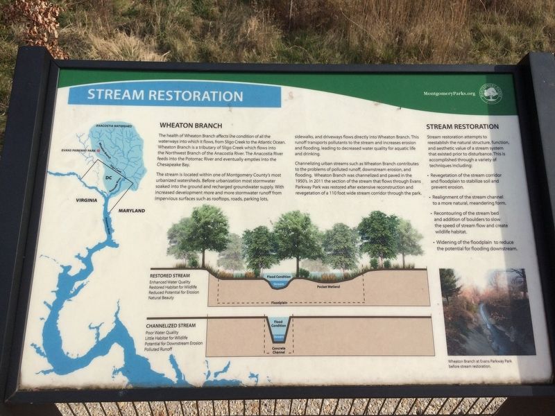
The health of Wheaton Branch affect the condition of all the waterways into which it flows, from Sligo Creek to the Atlantic Ocean. Wheaton Branch is a tributary of Sligo Creek which flows into the Northwest Branch of the Anacostia River. The Anacostia River feeds into the Potomac River and eventually empties into the Chesapeake Bay.
The stream is located within one Montgomery County's most urbanized watersheds. Before urbanization most stormwater soaked into the ground and recharged groundwater supply. With increased development more and more stormwater runoff from impervious surfaces such as rooftops, roads, parking lots, sidewalks, and driveways flows directly into Wheaton Branch. This runoff transports pollutants to the stream and increases erosion and flooding, leading to decreased water quality for aquatic life and drinking.
Channeling urban streams such as Wheaton Branch, contributes to the problems of polluted runoff, downstream erosion, and flooding. Wheaton Branch was channelized and paved in the 1950's. In 2011 the section of the stream that flows through Evans Parkway Park was restored after extensive reconstruction and vegetation of a 110 foot wide stream corridor through the park.
Stream Restoration
Stream restoration attempts to reestablish the natural structure, function, and aesthetic value of a stream system that existed prior to disturbance. This is accomplished through a variety of techniques including:
• Revegetation of the stream corridor and floodplain to stabilize soil and prevent erosion.
• Realignment of the stream channel to a more natural, meandering form.
• Recountouring of the stream bed and addition of boulders to slow the speed of stream flow and create wildlife habitat.
• Widening of the floodplain to reduce the potential for flooding downstream.
Restored Stream
Enhanced Water Quality
Restored Habitat for Wildlife
Reduced Potential for Erosion
Natural Beauty
Channelized Stream
Poor Water Quality
Little Habitat for Wildlife
Potential for Downstream Erosion
Polluted Runoff
Erected by Montgomery Parks.
Topics. This historical marker is listed in these topic lists: Environment • Waterways & Vessels.
Location. 39° 1.674′ N, 77° 2.571′ W. Marker is in Silver Spring, Maryland, in Montgomery County. It is in Wheaton. Marker can be reached from the intersection of Evans Parkway and Clinton Avenue, on the left when traveling east. Touch for map. Marker is at or near this postal address: 10514 Bucknell Dr, Silver Spring MD 20902, United States of America. Touch for directions.
Other nearby markers.
Credits. This page was last revised on February 21, 2023. It was originally submitted on November 25, 2017, by Devry Becker Jones of Washington, District of Columbia. This page has been viewed 182 times since then and 6 times this year. Photos: 1, 2. submitted on November 25, 2017, by Devry Becker Jones of Washington, District of Columbia. • Bill Pfingsten was the editor who published this page.

