Near Spotsylvania Courthouse in Spotsylvania County, Virginia — The American South (Mid-Atlantic)
A Missed Opportunity
The Battle of Chancellorsville
| — | Fredericksburg and Spotsylvania National Military Park | — |
Photographed by Craig Swain, May 9, 2009
1. A Missed Opportunity Marker
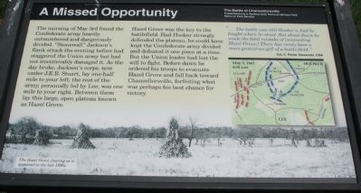
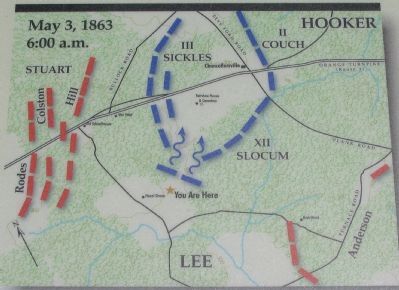
The morning of May 3d found the Confederate army heavily outnumbered and dangerously divided. "Stonewall" Jackson's flank attack the evening before had staggered the Union army but had not irretrievably damaged it. As the day broke, Jackson's corps, now under J.E.B. Stuart, lay one-half mile to your left; the rest of the army, personally led by Lee, was one mile to your right. Between them lay this large, open plateau known as Hazel Grove.
Hazel Grove was the key to the battlefield. Had Hooker strongly defended the plateau, he could have kept the Confederate army divided and defeated it one piece at a time. But the Union leader had lost the will to fight. Before dawn he ordered his troops to evacuate Hazle Grove and fall back toward Chancellorsville, forfeiting what was perhaps his best chance for victory.
"...The battle was still Hooker's, had he fought where he stood. But about dawn he made the fatal mistake of [evacuating Hazel Grove.] There has rarely been a more gratuitous gift of a battle-field."
Col. E. Porter Alexander, CSA
Erected by National Park Service, U.S. Department of the Interior.
Topics. This
this page online
Location. Marker has been reported missing. It was located near 38° 18.201′ N, 77° 39.071′ W. Marker was near Spotsylvania Courthouse, Virginia, in Spotsylvania County. It was on Stuart Drive, on the right when traveling south. Located at stop nine of the driving tour of Chancellorsville Battlefield. Touch for map. Marker was in this post office area: Spotsylvania VA 22553, United States of America. Touch for directions.

Regionally, this marker was in the Washington Metropolitan Area, in Northern Virginia, and in the Piedmont. It was also in the American South, specifically in the Upper South, in the Mid-Atlantic, and on the Eastern Seaboard. Globally, it was in the North Atlantic Region, North America, the Western Hemisphere, the Western World, and the Anglosphere. Historically, it found itself in what was once the territory of the Mississippian Culture, one of the original Thirteen Colonies, one of the Confederate States of America, and the Antebellum South.
Other nearby markers. At least 8 other markers
Photographed by Shane Oliver, October 7, 2017
2. A Missed Opportunity Marker Panel
The marker itself is missing, and has not been replaced. However, since the panel/base is still standing, there is a possibility that the NPS will replace the marker in the near future.
Another marker is no longer nearby. Chancellorsville Campaign (was a few steps from this marker but has been replaced with another marker now near it).
Photographed by Craig Swain, May 9, 2009
3. Close Up of the Map
Photographed by Craig Swain, May 9, 2009
4. A Missed Opportunity Marker
Credits. This page was last revised on July 9, 2021. It was originally submitted on May 18, 2009, by Craig Swain of Leesburg, Virginia. This page has been viewed 1,764 times since then and 21 times this year. Last updated on January 5, 2018, by Shane Oliver of Richmond, Virginia. Photos: 1. submitted on May 18, 2009, by Craig Swain of Leesburg, Virginia. 2. submitted on January 5, 2018, by Shane Oliver of Richmond, Virginia. 3, 4. submitted on May 18, 2009, by Craig Swain of Leesburg, Virginia. • J. J. Prats was the editor who published this page.
