Navy Yard in Southeast Washington in Washington, District of Columbia — The American Northeast (Mid-Atlantic)
Mildred Belle
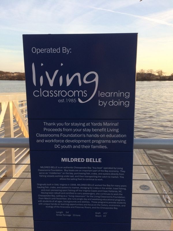
Mildred Belle is an authentic Chesapeake Bay "buy boat" operated by Living Classrooms Foundation. Buy boats are an important part of. the Bay economy. They serve as "middlemen" on the bay, purchasing fish, crabs, and oysters directly from the fishing vessels working under sail, and then transporting the catch to market. This allows the sailing fleet to continue to work
Originally built in Odd, Virginia in 1948, Mildred Belle worked the Bay for many years hauling fish, crabs, and oysters to market, dredging for crabs in the winter, trawl fishing and even pioneering sport fishing off the Virginia Capes and Cape Hatteras, NC. Having been rebuilt and certified to carry passengers, she continues to work the Chesapeake Bay, sailing as a "living classroom" for the Living Classrooms Foundation. From March until November, she runs single day and weeklong educational programs with students of all ages, backgrounds and abilities. These programs provide students with unique hands-on learning opportunities and focus on the history, economics, and ecology of the Anacostia and Potomac Rivers, and the Chesapeake Bay.
Length 54'
GrossTonnage 23 tons
Click or scan to see
this page online
Draft 4'5"
Beam 15'
Erected by Living Classrooms Foundation.
Topics. This historical marker is listed in these topic lists: Education • Industry & Commerce • Sports • Waterways & Vessels. A significant historical year for this entry is 1948.
Location. 38° 52.364′ N, 77° 0.027′ W. Marker is in Southeast Washington in Washington, District of Columbia. It is in Navy Yard. It is at the intersection of Anacostia Riverwalk Trail and 4th Street Southeast on Anacostia Riverwalk Trail. Touch for map. Marker is at or near this postal address: 1492 4th Street Southeast, Washington DC 20003, United States of America. Touch for directions.

Regionally, this marker is in the Washington Metropolitan Area. It is also in the American Northeast, in the Upper South, in the Mid-Atlantic, in the Tidewater, and in the Chesapeake Bay Region. Globally, it is in North America, the Western Hemisphere, the Western World, and the Anglosphere.
Other nearby markers. At least 6 other markers are within walking distance of this marker: River Revival (within shouting distance of this marker); The River in Focus (within
Other markers no longer nearby. 99M (was within shouting distance of this marker but has been replaced with another marker now near it); 1221 Van (was about 300 feet away, measured in a direct line but has been replaced with another marker now near it); Yards Park (was about 300 feet away but has been replaced with another marker now near it); Nationals Park (was about 300 feet away but has been replaced with another marker now near it); Audi Field (was about 300 feet away but has been replaced with another marker now near it); Dock 79 (was about 300 feet away but has been replaced with another marker now near it); USDOT (was about 300 feet away but has been replaced with another marker now near it); The Bixby (was about 300 feet away but has been replaced with another marker now near it); The Lumber Shed (was about 300 feet away but has been replaced with another marker now near it); Twelve12 (was about 300 feet away but has been replaced with another marker now near it).
Credits. This page was last revised on January 12, 2026. It was originally submitted on February 15, 2018, by Devry Becker Jones of Washington, District of Columbia. This page has been viewed 641 times since then and 19 times this year. Photos: 1, 2. submitted on February 15, 2018, by Devry Becker Jones of Washington, District of Columbia. • Bill Pfingsten was the editor who published this page.
