Annapolis in Anne Arundel County, Maryland — The American Northeast (Mid-Atlantic)
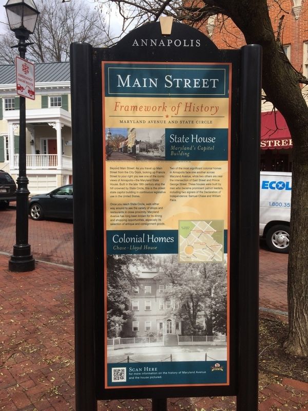
Framework of History
Main Street
— Maryland Avenue and State Circle —
Beyond Main Street: As you travel up Main Street from the City Dock, looking up from Francis Street to your right you see one of the iconic views of Annapolis—the Maryland State House. Built in the late 18th century atop the hill crowned by State Circle, this is the oldest state capitol building in continuous legislative use in the United States.
Once you reach State Circle, walk either way around to see the variety of shops and restaurants in close proximity. Maryland Avenue has long been known for its dining and shopping opportunities, especially its selection of antique and consignment goods.
Two of the most significant colonial homes in Annapolis face one another across Maryland Avenue, while two others are near the intersection of East Street and Prince George Street. These houses were built by men who became prominent patriot leaders, including two signers of the Declaration of Independence: Samuel Chase and William Paca.
Topics. This historical marker is listed in these topic lists: Architecture • Colonial Era • Government & Politics • Patriots & Patriotism.
Location. 38° 58.67′ N, 76° 29.365′ W. Marker is in Annapolis, Maryland, in Anne Arundel County. Marker is at the intersection of Main Street and Francis Street on Main Street. Touch for map. Marker is at or near this postal address: 152 Main Street, Annapolis MD 21401, United States of America. Touch for directions.
Other nearby markers. At least 8 other markers are within walking distance of this marker. Planned in the Past (a few steps from this marker); Gov. Francis Nicholson (a few steps from this marker); 159 Main Street (within shouting distance of this marker); 163 Main Street (within shouting distance of this marker); 167 Main Street at Conduit Street (within shouting distance of this marker); 41 Cornhill Street (within shouting distance of this marker); Mann's Tavern (about 300 feet away, measured in a direct line); Cornhill & Fleet Streets (about 300 feet away). Touch for a list and map of all markers in Annapolis.
Credits. This page was last revised on April 11, 2024. It was originally submitted on March 2, 2018, by Devry Becker Jones of Washington, District of Columbia. This page has been viewed 237 times since then and 9 times this year. Photos: 1, 2, 3. submitted on March 2, 2018, by Devry Becker Jones of Washington, District of Columbia. • Bill Pfingsten was the editor who published this page.


