Davidsonville in Anne Arundel County, Maryland — The American Northeast (Mid-Atlantic)
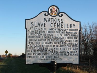
Watkins Slave Cemetery
Erected by Maryland Historical Trust, Maryland State Highway Administration.
Topics and series. This historical marker is listed in these topic lists: African Americans • Cemeteries & Burial Sites • Churches & Religion • War, US Civil. In addition, it is included in the Maryland Historical Trust series list. A significant historical year for this entry is 1960.
Location. 38° 57.389′ N, 76° 38.812′ W. Marker is in Davidsonville, Maryland, in Anne Arundel County. Marker is on Old Davidsonville Road (Maryland Route 424) half a mile south of John Hanson Highway (U.S. 50), on the right when traveling south. Touch for map. Marker is at or near this postal address: 1157 Old Davidsonville Rd, Davidsonville MD 21035, United States of America. Touch for directions.
Other nearby markers. At least 8 other markers are within 5 miles of this marker, measured as the crow flies. Middle Plantation (approx. 1.1 miles away); Linthicum Walks (approx. 3.2 miles away); Melford and Cemetery (approx. 3.4 miles away); Mt. Tabor United Methodist Church (approx. 3.6 miles away); Williams Plains (approx. 4.3 miles away); Forest Place (approx. 4.4 miles away); Historic Pin Oak (approx. 4.4 miles away); Sacred Heart Chapel - White Marsh (approx. 4.4 miles away).
Credits. This page was last revised on April 3, 2023. It was originally submitted on October 12, 2007, by F. Robby of Baltimore, Maryland. This page has been viewed 9,490 times since then and 152 times this year. Last updated on March 11, 2018, by Devry Becker Jones of Washington, District of Columbia. Photos: 1. submitted on October 12, 2007, by F. Robby of Baltimore, Maryland. 2. submitted on November 6, 2007, by F. Robby of Baltimore, Maryland. • Bill Pfingsten was the editor who published this page.

