Memphis in Shelby County, Tennessee — The American South (East South Central)
Head of Passes/Pilottown, Louisiana
Mississippi River Walk
Photographed by Jason Voigt, August 2, 2024
1. Head of Passes/Pilottown, Louisiana Marker
Marker was replaced with a newer one, placed by Mud Island Park
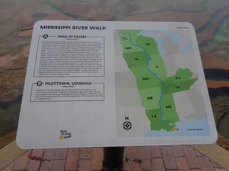
A) Head of Passes
Mile 0.0 AHP
The Mississippi River officially ends here, 954 miles from Cairo, Illinois. At this point, the stream divides into three channels, Pass a Louture, South Pass, and Southern Pass. They each branch into smaller passes and all eventually empty into the Gulf of Mexico. Early French navigators favored the Southeast Pass off Pass a Louture, and France fortified an outpost named Baliz on its banks. The first U.S. Civil War battle was fought at the Head of Passes in 1861. It was one of the few Confederate naval victories of the war. The Passes were a constant problem for the growing port of New Orleans in the 1800’s. At high water, a passage was easy, but at low water heavy ships often could not find an open channel between the river and sea. In 1875, the U. S. Congress contracted with the pioneering river engineer, Captain James B. Eads to open a reliable channel to the sea. (Eads had completed building the giant bridge over the Mississippi River at St. Louis the previous year.) Congress drove a hard bargain with Eads: if he failed they paid him nothing; if he succeeded they would pay him eight
this page online
B) Pilottown, Louisiana
Mile 2.0 AHP
Pilottown is the interchange point for bar pilots and river pilots on the ocean-going vessels that navigate the Mississippi. Bar pilots meet ships at sea and guide them through the passes and up to Pilottown. River pilots take over for the journey to ports on the Mississippi River. The process is reversed on outgoing trips.
Erected by Mississippi Riverwalk. (Marker Number 1.)
Topics. This historical marker is listed in these topic lists: Exploration • Forts and Castles • War, US Civil • Waterways & Vessels.
Location. 35° 8.756′ N, 90° 3.507′ W. Marker is in Memphis, Tennessee, in Shelby County. It can be reached from Island Drive 0.8 miles south of West A.W. Willis Avenue when traveling south. Located at Mud Island Park. Touch for map.

Photographed by Sandra Hughes, May 18, 2010
2. Head of Passes Marker

Regionally, this marker is in West Tennessee. It is also in the American South, specifically in the Deep South, in the Upper South, in the Mississippi Delta, and in the Great River Road Region. Globally, it is in North America, the Western Hemisphere, the Western World, and the Anglosphere. Historically, it finds itself in what was once the territory of the Mississippian Culture, one of the Confederate States of America, and the Antebellum South.
Other nearby markers. At least 8 other markers are within walking distance of this marker: Venice Louisiana/Fort Jackson, Louisiana/Fort St. Phillip (a few steps from this marker); Ostrica Lock/Buras, Louisiana/Empire Lock/Nairn, Louisiana (a few steps from this marker); Point a La Hache, Louisiana/ Magnolia Plantation, Louisiana (within shouting distance of this marker); Junior Crevasse/Poverty Point, Louisiana/Jesuits Bend (within shouting distance of this marker); Belle Chasse, Louisiana/English Turn Bend/Caernarvon Crevasse/Poydras Crevasse (within

Photographed by Jason Voigt, August 2, 2024
3. Head of Passes/Pilottown, Louisiana Marker
Memphis skyline is in the background
Also see . . .
1. Head of Passes. During the American Civil War, Head of Passes was the site of several naval battles. The Anaconda Plan called for a large Union blockade of the Confederacy, and included plans to control the Mississippi River. This began in 1861 with a Union blockade stationed at the Head of Passes. This occupation resulted in the Battle of the Head of Passes, where the blockading forces were temporarily driven from the area. Ships involved in the ensuing conflict at the location include the CSS Manassas, the USS Vincennes, and the USS Richmond. (Submitted on March 12, 2018, by Sandra Hughes Tidwell of Killen, Alabama, USA.)
2. Pilottown, Louisiana. Pilottown was constructed and settled after September 1860 in its current location. It replaced the earlier village of La Balize, that had been founded more than 160 years earlier downriver. After the hurricane of September 14–15, 1860, blew its buildings down and destroyed the area in a storm surge, La Balize was finally abandoned. The main river passage was moved to the Southwest Pass, because of its deeper water. The Mississippi River pilots built their new settlement upriver above Head of Passes. They named it Pilottown. (Submitted on March 12, 2018, by Sandra Hughes Tidwell of Killen, Alabama, USA.)
Credits. This page was last revised on August 10, 2024. It was originally submitted on March 12, 2018, by Sandra Hughes Tidwell of Killen, Alabama, USA. This page has been viewed 1,179 times since then and 87 times this year. Photos: 1. submitted on August 10, 2024, by Jason Voigt of Glen Carbon, Illinois. 2. submitted on March 12, 2018, by Sandra Hughes Tidwell of Killen, Alabama, USA. 3. submitted on August 10, 2024, by Jason Voigt of Glen Carbon, Illinois. • Bernard Fisher was the editor who published this page.
