Memphis in Shelby County, Tennessee — The American South (East South Central)
The Battle of New Orleans
Chalmette, Louisiana
| — | Mississippi River Walk | — |
Photographed by Jason Voigt, August 2, 2024
1. The Battle of New Orleans Marker
Marker was replaced with a newer one put up by Mud Island Park.
Mile 90.2 AHP
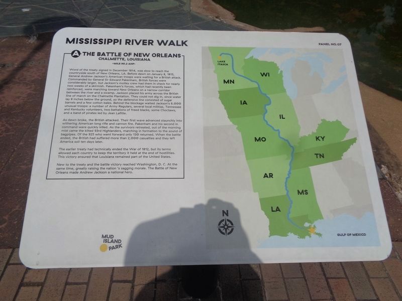
Word of the treaty signed in December 1814, was slow to reach the countryside south of New Orleans, LA. Before dawn on January 8, 1815, General Andrew Jackson’s American troops were waiting for a British attack. Commanded by General Sir Edward Pakenham, British forces were considerably larger, but Jackson’s motley crew had them in check for nearly two weeks of a skirmish. Pakenham’s forces, which had recently been reinforced, were marching toward New Orleans on a narrow corridor between the river and a swamp. Jackson placed his army across the British line of march on the Chalmette Plantation. They could not dig in, since water lay 8 inches below the ground, so the defensive line consisted of sugar barrels and a few cotton bales. Behind the blockage waited Jackson’s 6.000 unusual troops: a number of Army Regulars, several local militias, Tennessee and Kentucky volunteers, two battalions of freed blacks, some Choctaw Indians, and a band of pirates led by Jean Lafitte.
As dawn broke, the British attacked. Their first wave advanced staunchly into withering American long rifle and cannon fire. Pakenham
this page online
The earlier treaty had technically ended the War of 1812, but its terms allowed each country to keep the territory it held at the end of hostilities. This victory ensured that Louisiana remained part of the United States.
New to the treaty and the battle victory reached Washington, D. C. At the same time, greatly raising the nation ’s sagging morale. The Battle of New Orleans made Andrew Jackson a national hero.
Photo Credit: American Canon at War of 1812 Battlefield at Chalmette, Louisiana/Jean Lafitte National Park & Preserve - Louisiana Office of Tourism
Erected by Mississippi Riverwalk. (Marker Number 7.)
Topics and series. This historical marker is listed in these topic lists: Indigenous Peoples and Communities • War of 1812 • Waterways & Vessels. In addition,

Photographed by Sandra Hughes, May 18, 2010
2. The Battle of New Orleans Marker
Location. 35° 8.782′ N, 90° 3.529′ W. Marker is in Memphis, Tennessee, in Shelby County. It can be reached from Island Drive 0.8 miles south of West A.W. Willis Avenue when traveling south. Located in Mud Island Park. Touch for map. Marker is at or near this postal address: 25 Island Dr, Memphis TN 38103, United States of America. Touch for directions.

Regionally, this marker is in West Tennessee. It is also in the American South, specifically in the Deep South, in the Upper South, in the Mississippi Delta, and in the Great River Road Region. Globally, it is in North America, the Western Hemisphere, the Western World, and the Anglosphere. Historically, it finds itself in what was once the territory of the Mississippian Culture, one of the Confederate States of America, and the Antebellum South.
Other nearby markers. At least 8 other markers are within walking distance of this marker: Belle Chasse, Louisiana/English Turn Bend/Caernarvon Crevasse/Poydras Crevasse (a few steps from this marker); New Orleans, Louisiana
Photographed by Jason Voigt, August 2, 2024
3. The Battle of New Orleans Marker
Also see . . . Battle of New Orleans. By December 12, 1814, sixty British ships with 14,450 soldiers and sailors aboard, under the command of Admiral Sir Alexander Cochrane, had anchored in the Gulf of Mexico to the east of Lake Pontchartrain and Lake Borgne.[4][18] Preventing access to the lakes was an American flotilla, commanded by Lieutenant Thomas ap Catesby Jones, consisting of five gunboats. On December 14, around 1,200 British sailors and Royal Marines under Captain Nicholas Lockyer[19] set out to attack Jones' force. Lockyer's men sailed in 42 longboats, each armed with a small carronade. (Submitted on March 12, 2018, by Sandra Hughes Tidwell of Killen, Alabama, USA.)
Credits. This page was last revised on August 14, 2024. It was originally submitted on March 12, 2018, by Sandra Hughes Tidwell of Killen, Alabama, USA. This page has been viewed 479 times since then and 47 times this year. Photos: 1. submitted on August 14, 2024, by Jason Voigt of Glen Carbon, Illinois. 2. submitted on March 12, 2018, by Sandra Hughes Tidwell of Killen, Alabama, USA. 3. submitted on August 14, 2024, by Jason Voigt of Glen Carbon, Illinois. • Bernard Fisher was the editor who published this page.
