Memphis in Shelby County, Tennessee — The American South (East South Central)
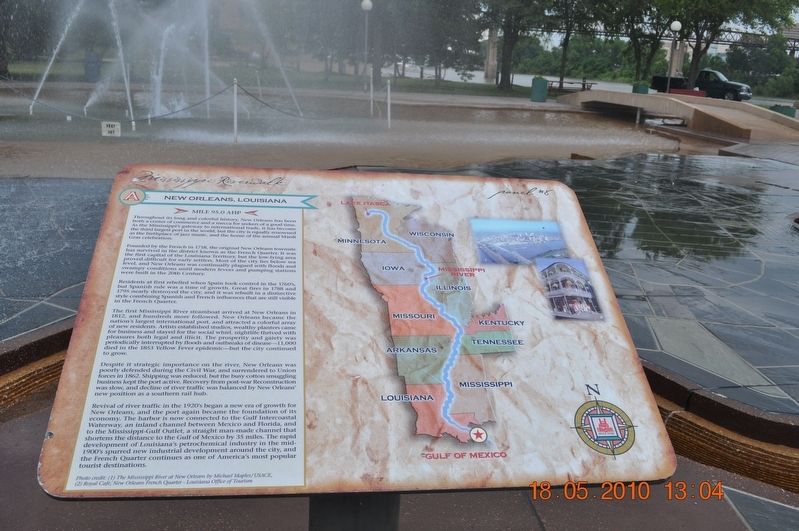
New Orleans, Louisiana
Panel #8 Mississippi Riverwalk
Mile 95.0 AHP
Throughout its long and colorful history, New Orleans has been both a center of commerce and Mecca for seekers of a good time. As the Mississippi’s gateway to international trade, it has become the third largest port in the world, but the city is equally renowned as the birthplace of jazz music, and the home of the annual Mardi Gras celebration.
Founded by the French in 1718, the original New Orleans townsite has survived in the district known as French Quarters. It was the first capital of the Louisiana Territory but the low-lying area proved difficult for early settlers. Most of the city lies below sea level, and New Orleans was continually leagued with floods and swampy conditions until modern levees and pumping stations were built in the 20th Century.
Residents at first rebelled when Spain took control in the 1760’s, but Spanish rule was a time of growth. Great fires in 1788 and 1795 nearly destroyed the city, and it was rebuilt in a distinctive style combining Spanish and French influences that are still visible in the French Quarter.
The first Mississippi River steamboat arrived at New Orleans in 1812, and hundreds more followed. New Orleans became the nation’s largest international port and attracted a colorful array of new3 residents. Artists established studios wealthy planters came for business and stayed for the social whirl, nightlife thrived with pleasures both legal and illicit. The prosperity and gaiety were periodically interrupted by floods, an outbreak of disease-1,000 died in 1853 Yellow Fever epidemic-but the city continued to grow.
Despite its strategic importance on the river, New Orleans was poorly defended during the Civil War and surrendered to Union forces in 1862. Shipping was reduced, but the busy cotton smuggling business kept the port active. Recovery from post-war Reconstruction was slow, and decline of river traffic was balanced by New Orleans’ new position as a southern rail hub.
Revival of river traffic in the 1920’s began a new era of growth for New Orleans, and the port again became the foundation of its economy. The harbor is now connected to the Gulf Intercoastal Waterway, an inland channel between Mexico and Florida, and to the Mississippi-Gulf Outlet, a straight man-made channel that shortened the distance to the Gulf of Mexico by 35 miles. The rapid development of Louisiana’s petrochemical industry in the mid-1900’s spurred new industrial development around the city, and the French Quarter continues as one of America’s most popular tourist destinations.
Photo Credit: (1) the Mississippi River at New Orleans by Michael Maples/USACE, (2) Royal Cafe; New Orleans French Quarter - Louisiana Office of Tourism
Erected by Mississippi Riverwalk. (Marker Number 8.)
Topics. This historical marker is listed in these topic lists: Disasters • Industry & Commerce • Settlements & Settlers • Waterways & Vessels. A significant historical year for this entry is 1718.
Location. 35° 8.968′ N, 90° 3.507′ W. Marker is in Memphis, Tennessee, in Shelby County. Marker can be reached from Island Drive, 0.8 miles south of West A.W. Willis Avenue when traveling south. Located in Mud Island River Park. Touch for map. Marker is at or near this postal address: 125 N Front St, Memphis TN 38103, United States of America. Touch for directions.
Other nearby markers. At least 8 other markers are within walking distance of this marker. The Mississippi Riverwalk (here, next to this marker); Ohio River (here, next to this marker); Cairo, Illinois (here, next to this marker); Islands No. 2, 3, and 4 / Fort Jefferson, Kentucky / Bird’s Point, Missouri (here, next to this marker); Island No. 5 (Wolf Island)/Belmont, Missouri/Columbus, Kentucky (here, next to this marker); Donaldson Point, Missouri/Island No. 8/Hickman, Kentucky/Dorena Crevasse (here, next to this marker); New Madrid, Missouri/Cates Casting Field/Island No. 10 (here, next to this marker); Tiptonville, Tennessee/Bixby Towhead (here, next to this marker). Touch for a list and map of all markers in Memphis.
Also see . . . New Orleans. New Orleans is located in southeastern Louisiana, and occupies both sides of the Mississippi River. The heart of the city and its French Quarter is on the river's north side. The city and Orleans Parish (French: paroisse d'Orléans) are coterminous.[20] The city and parish are bounded by the parishes of St. Tammany to the north, St. Bernard to the east, Plaquemines to the south, and Jefferson to the south and west.[20][21][22] Lake Pontchartrain, part of which lies within the city limits, lies to the north and Lake Borgne lies to the east.[22] (Submitted on March 12, 2018, by Sandra Hughes Tidwell of Killen, Alabama, USA.)
Credits. This page was last revised on March 13, 2018. It was originally submitted on March 12, 2018, by Sandra Hughes Tidwell of Killen, Alabama, USA. This page has been viewed 186 times since then and 12 times this year. Photo 1. submitted on March 12, 2018, by Sandra Hughes Tidwell of Killen, Alabama, USA. • Bernard Fisher was the editor who published this page.
Editor’s want-list for this marker. Wide shot of marker and its surroundings. • Can you help?
