
Memphis in Shelby County, Tennessee — The American South (East South Central)
Lutcher, Louisiana/Oak Alley/St. James Landing, Louisiana
Mississippi River Walk

Photographed by Jason Voigt, August 2, 2024
1. Lutcher, Louisiana/Oak Alley/St. James Landing, Louisiana Marker
Marker was replaced with a newer one put up by Mud Island Park.
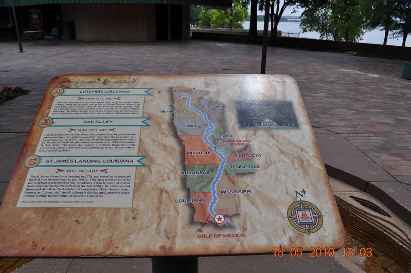
A) Lutcher, Louisiana
Mile 147.6 AHP
Tobacco was never a very successful cash crop for early French settlers, with the notable exception of Pierre Channet, who lived near here. The “Perique tobacco” he developed is still grown only on a narrow ridge near Lutcher and is one of the world’s costliest tobaccos. The Black Perique is so strong it must cure for three years and is blended with milder tobacco to add its distinctive flavor.
B) Oak Alley
Mile 152.5 AHP
A long double row of Oak Trees was planted here by an unknown settler and the river pilots named the spot after the trees they saw towering over the levee. The oaks were already impressive when J. T. Roman III built his plantation house here in 1836 and named it Oak Alley. The trees still stand, and their branches form a towering canopy 300 feet long leading up to the house, which is still standing today.
C) St. James Landing, Louisiana
Mile 156.7 AHP
The St James church was founded in 1770 and served as a landmark until it was demolished in the 1930’s. This area is believed to be the original settlement of the Acadians, French colonist exiled from
this page online
Photo credit: Oak Alley Plantation, Louisiana Office of Tourism
Erected by Mississippi Riverwalk. (Marker Number 12.)
Topics. This historical marker is listed in these topic lists: Settlements & Settlers • Waterways & Vessels. A significant historical year for this entry is 1836.
Location. 35° 8.784′ N, 90° 3.556′ W. Marker is in Memphis, Tennessee, in Shelby County. It can be reached from Island Drive 0.8 miles south of West A.W. Willis Avenue when traveling south. Located in Mud Island Park. Touch for map. Marker is at or near this postal address: 25 Island Dr, Memphis TN 38103, United States of America. Touch for directions.

Regionally, this marker is in West Tennessee. It is also in the American South, specifically in the Deep South, in the Upper South, in the Mississippi Delta, and in the Great River Road Region. Globally, it is in North America, the Western Hemisphere,
Photographed by Sandra Hughes, May 18, 2010
2. Lutcher, Louisiana/Oak Alley/St. James Landing, Louisiana Marker
Other nearby markers. At least 8 other markers are within walking distance of this marker: White Hall Plantation/Union, Louisiana/Point Houmas (here, next to this marker); Hymelia Crevasse/Bonnet Carre Crevasse/Laplace, Louisiana/Reserve, Louisiana (a few steps from this marker); Donaldsonville, Louisiana/Bayou Lafourche/Geismar, Louisiana (a few steps from this marker); Claiborne Landing / Carville, Louisiana / Belle Grove (a few steps from this marker); Bonnet Carre Spillway/Lake Pontchartrain (a few steps from this marker); Kenner, Louisiana/Davis Crevasse/Ormand Landing, Louisiana (within shouting distance of this marker); Plaquemine, Louisiana/Manchac Bend (within shouting distance of this marker); Baton Rouge, Louisiana (within shouting distance of this marker). Touch for a list and map of all markers in Memphis.
Also see . . .
1. Lutcher, Louisiana. Lutcher was established as a sawmill town, named after Henry J.

Photographed by Jason Voigt, August 2, 2024
3. Lutcher, Louisiana/Oak Alley/St. James Landing, Louisiana Marker
2. Types of Tobacco. Perhaps the most strongly flavored of all tobaccos is the Perique, from Saint James Parish, Louisiana. When the Acadians made their way into this region in 1755, the Choctaw and Chickasaw tribes were cultivating a variety of tobacco with a distinctive flavor. A farmer called Pierre Chenet is credited with first turning this local tobacco into the Perique in 1824 through the technique of pressure-fermentation. Considered the truffle of pipe tobaccos, the Perique is used as a component of many blended pipe tobaccos, but is too strong to be smoked pure. At one time, the freshly moist Perique was also chewed, but none is now sold for this purpose. It is traditionally a pipe tobacco, and is still very popular with pipe-smokers, typically blended with pure Virginia to lend spice, strength, and coolness to the blend. (Submitted on March 12, 2018, by Sandra Hughes Tidwell of Killen, Alabama, USA.)
Credits. This page was last revised on August 15, 2024. It was originally submitted on March 12, 2018, by Sandra Hughes Tidwell of Killen, Alabama, USA. This page has been viewed 808 times since then and 53 times this year. Photos: 1. submitted on August 15, 2024, by Jason Voigt of Glen Carbon, Illinois. 2. submitted on March 12, 2018, by Sandra Hughes Tidwell of Killen, Alabama, USA. 3. submitted on August 15, 2024, by Jason Voigt of Glen Carbon, Illinois. • Bernard Fisher was the editor who published this page.
