
Colesville in Silver Spring in Montgomery County, Maryland — The American Northeast (Mid-Atlantic)
Snowden's Mill
Inside the Mill
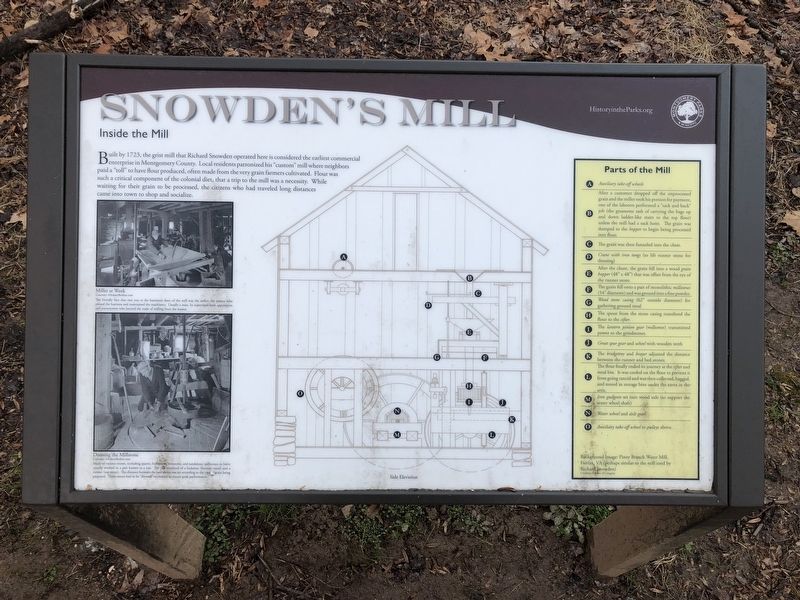
Built by 1723, the grist mill that Richard Snowden operated here is considered the earliest commercial enterprise in Montgomery County. Local resident patronized his "custom" mill where neighbors paid a "toll" to have flour produced, often made from the very grain farmers cultivated. Flour was such a critical component of the colonial diet, that a trip to the mill was a necessity. While waiting for their grain to be processed, the citizens who had traveled long distances came into town to shop and socialize.
[Captions:]
Miller at Work
Courtesy: AAubreyBodine.com
The friendly face that met you at the basement door of the mill was the miller, the person who owned the business and maintained the machinery. Usually a man, he supervised both apprentices and journeymen who learned the trade of milling from the master.
Dressing the Millstone
Courtesy: AAubreyBodine.com Made of various stones, including quartz, buhrstone, limestone, and sandstone, millstones or burrs usually worked in a pair known as a run. The run consisted of a bedstone (bottom stone) and a runner (top stone). The distance between
this page online
[Sidebar:]
A Auxiliary take-off wheels
B After a customer dropped off the unprocessed grain and the miller took his portion for payment, one of the laborers performed a "sack and back" job (the gruesome task of carrying the bags up and down the ladder-like stairs to the top floor) unless the mill had a sack hoist. The grain was dumped to the hopper to begin being processed into flour.
C The grain was then funneled into the chute.
D Crane with iron tongs (to lift runner stone for dressing)
E After the chute, the grain fell into a wood grain hopper (48" x 48") that was offset from the eye of the runner stone.
F The grain fell onto a pair of monolithic millstones (54" diameter) and was ground into a fine powder.
G Wood stone casing (62" outside diameter) for gathering ground meal
H The spout from the stone casing transferred the flour to the sifter.
I The lantern pinion gear (wallower) transmitted power to the sifter.
J Great spur gear and wheel with wooden teeth
K
L The flour finally ended its journey at the sifter and meal bin. It was cooled on the floor to prevent it from going rancid and was then collected, bagged, and stored in storage bins under the eaves in the attic.
M Iron gudgeon set into wood axle (to support the water wheel shaft)
N Water wheel and axle gear
O Auxiliary take-off wheel to pulleys above.
Background image: Piney Branch Water Mill, Fairfax, VA (perhaps similar to the mill used by Richard Snowden)
Courtesy: Library of Congress
Erected by Montgomery Parks.
Topics and series. This historical marker is listed in these topic lists: Agriculture • Colonial Era • Industry & Commerce. In addition, it is included in the Maryland, Montgomery Parks series list. A significant historical year for this entry is 1723.
Location. 39° 4.279′ N, 76° 58.546′ W. Marker is in Silver Spring, Maryland, in Montgomery County. It is in Colesville. It is on Paint Branch Trail east of Collingwood Terrace, on the left when traveling south. Touch for map. Marker is at or near this postal address:
Photographed by Devry Becker Jones (CC0), March 31, 2018
3. Nearest entrance access to the trail is Tamarack Park
along Collingwood Terrace near the intersection with Lemontree Lane

Regionally, this marker is in the Washington Metropolitan Area. It is also in the American Mid-Atlantic. Globally, it is in North America, the Western Hemisphere, the Western World, and the Anglosphere. Historically, it finds itself in what was once one of the original Thirteen Colonies and also the Antebellum South.
Other nearby markers. At least 8 other markers are within 3 miles of this marker, measured as the crow flies: Edmonston's Mill (approx. 0.3 miles away); Fawcett's Mill (approx. 0.4 miles away); a different marker also named Valley Mill (approx. 0.4 miles away); Smithville Colored School (approx. 1.1 miles away); Lee Family Cemetery (approx. 1½ miles away); Khmer Rouge Genocide Memorial (approx. 1.6 miles away); Rachel Carson House (approx. 2.2 miles away); The Commonwealth Farm (approx. 2.2 miles away). Touch for a list and map of all markers in Silver Spring.
Another marker is no longer nearby. Valley Mill (was approx. 0.4 miles away but has been permanently removed).
More about this marker. Nearest road access to Paint Branch trail is Tamarack Park, near the intersection of Collingwood Terrace and Lemontree Lane. Enter the trail at the park entrance and turn right at the fork. The marker will be on the left.
Credits. This page was last revised on December 13, 2023. It was originally submitted on April 1, 2018, by Devry Becker Jones of Washington, District of Columbia. This page has been viewed 875 times since then and 44 times this year. Photos: 1, 2, 3. submitted on April 1, 2018, by Devry Becker Jones of Washington, District of Columbia. • Bill Pfingsten was the editor who published this page.
