Near Liberty Corner in Somerset County, New Jersey — The American Northeast (Mid-Atlantic)
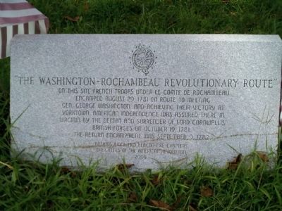
The Washington-Rochambeau Revolutionary Route
Erected 2006 by Basking Ridge and Beacon Fire Chapters of the Daughters of the American Revolution.
Topics and series. This historical marker is listed in these topic lists: Colonial Era • Heroes • Notable Events • Patriots & Patriotism • War, US Revolutionary. In addition, it is included in the Daughters of the American Revolution, the Former U.S. Presidents: #01 George Washington, and the The Washington-Rochambeau Route series lists. A significant historical month for this entry is September 1866.
Location. 40° 39.611′ N, 74° 34.704′ W. Marker is near Liberty Corner, New Jersey, in Somerset County. Marker is on Valley Road just south of Church Street, on the right when traveling south. Touch for map. Marker is at or near this postal address: 3625 Valley Rd, Basking Ridge NJ 07920, United States of America. Touch for directions.
Other nearby markers. At least 8 other markers are within 3 miles of this marker, measured as the crow flies. French Army Encampment (about 800 feet away, measured in a direct line); Bernards Township WWI & WWII Memorial (approx. 0.3 miles away); Chief Philip Koechlein (approx. 0.6 miles away); "We're Coming Up Behind You" (approx. 0.7 miles away); A Place To Remember (approx. 0.8 miles away); Purvis James Boatwright Jr. (approx. 1.9 miles away); Vail Family (approx. 2.3 miles away); Lyons Station (approx. 2.3 miles away). Touch for a list and map of all markers in Liberty Corner.
Regarding The Washington-Rochambeau Revolutionary Route. Marker is located near Jockey Hollow, Washington's HQ in Morristown, and Washington's Rock.
Credits. This page was last revised on June 16, 2016. It was originally submitted on September 18, 2008, by Stephen Connelly of Bayonne, New Jersey. This page has been viewed 1,565 times since then and 28 times this year. Photo 1. submitted on September 18, 2008, by Stephen Connelly of Bayonne, New Jersey. • Kevin W. was the editor who published this page.
