Stanton in Adams County, Mississippi — The American South (East South Central)
One Mound Among Many
July 7, 2017
1. One Mound Among Many Marker
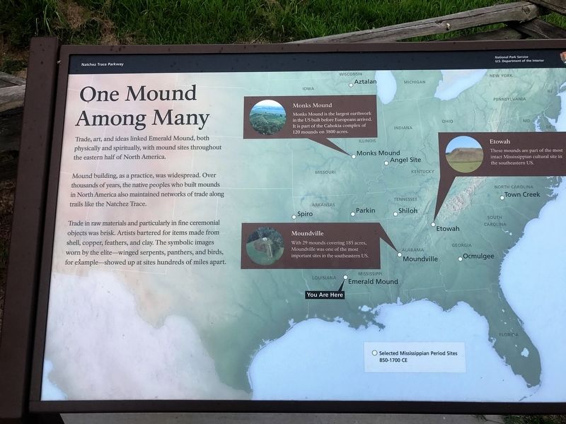
Trade, art, and ideas linked Emerald Mound, both physically and spiritually, with mound sites throughout the eastern half of North America.
Mound building, as a practice, was widespread. Over thousands of years, the native peoples who built mounds in North America also maintained networks of trade along trails like the Natchez Trace.
Trade in raw materials and particularly in fine ceremonial objects was brisk. Artists bartered for items made from shell, copper, feathers, and clay. The symbolic images worn by the elite - winged serpents, panthers, and birds, for example - showed up at sites hundreds of miles apart.
Photo Captions
Monks Mound
Monks mound is the largest earthwork in the US built before Europeans arrived. It is part of the Cahokia complex of 120 mounds on 3800 acres.
Etowah
These mounds are part of the most intact Mississippian cultural site in the southeastern US.
Moundville
With 29 mounds covering 185 acres, Moundville was one of the most important sites in the southeastern US.
Erected by National Park Service.
Topics. This historical marker is listed in this topic list: Indigenous Peoples and Communities.
Location. 31° 38.124′ N,
this page online

Regionally, this marker is in Southwest Mississippi and in Natchez Trace Corridor. It is also in the American South, specifically in the Deep South, and in the Great River Road Region. Globally, it is in North America, a Gulf of Mexico state, the Western Hemisphere, the Western World, and the Anglosphere. Historically, it finds itself in what was once New Spain, the Viceroyalty of New France, the territory of the Mississippian Culture, one of the Confederate States of America, and the Antebellum South.
Other nearby markers. At least 8 other markers are within 2 miles of this marker, measured as the crow flies: Still Sacred (here, next to this marker); Emerald Mound (here, next to this marker); a different marker also named Emerald Mound (here, next to this marker); A Well-Organized Society (a few steps from this marker);
July 7, 2017
2. One Mound Among Many Marker
Another marker is no longer nearby. A National Road (was approx. 1½ miles away but has been confirmed missing).
Credits. This page was last revised on April 5, 2018. It was originally submitted on April 5, 2018, by Cajun Scrambler of Assumption, Louisiana. This page has been viewed 363 times since then and 24 times this year. Photos: 1, 2. submitted on April 5, 2018.
