Old River
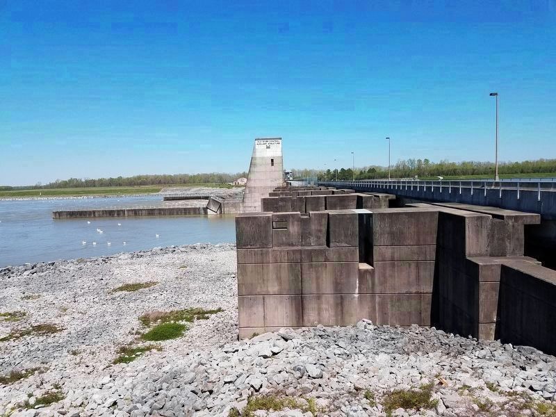
Old River Control Complex
— Atchafalaya Water Heritage Trail —
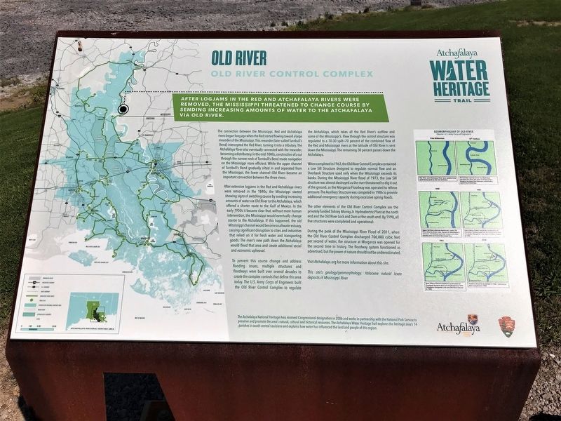
After logjams in the Red and Atchafalaya Rivers were removed, the Mississippi threatened to change course by sending increasing mounts of water to the Atchafalaya via Old River.
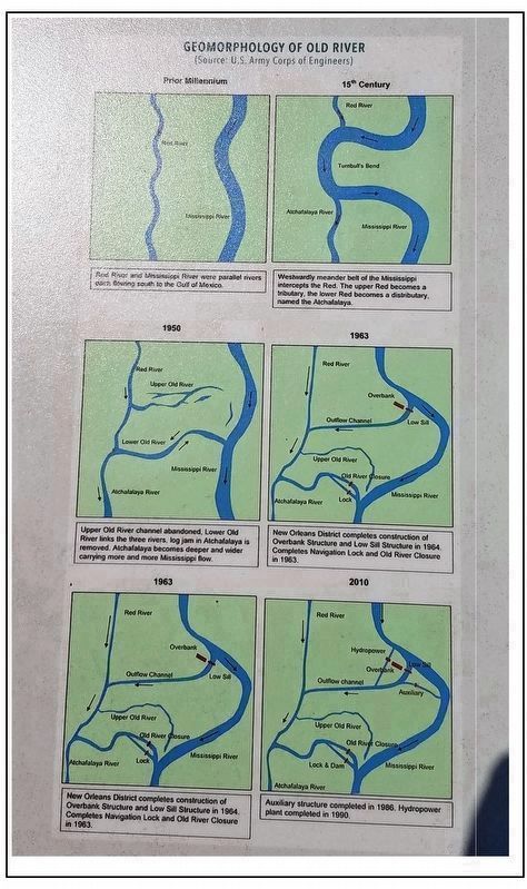
The connection between the Mississippi, Red and Atchafalaya rivers began long ago when the Red started flowing toward a large meander of the Mississippi. This meander (later called Turnbull’s Bend) intercepted the Red River, turning it into a tributary. The Atchafalaya River also eventually connected with the meander, becoming a distributary. In the mid-1800s, construction of a cut through the narrow neck of Turnbull’s Bend made navigation on the Mississippi more efficient. While the upper channel of Turnbull’s Bend gradually silted in and separated from the Mississippi, the lower channel—Old River—became an important connection between the three rivers.
After extensive logjams in the Red and Atchafalaya rivers were removed in the 1840s, the Mississippi started showing signs of switching course by sending increasing amounts of water via Old River to the Atchafalaya, which offered a shorter route to the Gulf of Mexico. In the early 1950s it became clear that, without more human intervention, the Mississippi would eventually change course to the Atchafalaya. If this happened, the old Mississippi channel would become a saltwater estuary,
causing significant disruption to cities and industries that relied on it for fresh water and transporting goods. The river’s new path down the Atchafalaya would flood that area and create additional social and economic upheaval.To prevent this course change and address flooding issues, multiple structures and floodways were built over several decades to create the complex controls that define this area today. The U.S. Army Corps of Engineers built the Old River Control Complex to regulate the Atchafalaya, which takes all the Red River’s outflow and some of the Mississippi’s. Flow through the control structure was regulated to a 70-30 split—70 percent of the combined flow of the Red and Mississippi rivers at the latitude of Old River is sent down the Mississippi. The remaining 30 percent passes down the Atchafalaya.
When completed in 1963, the Old River Control Complex contained a Low Sill Structure designed to regulate normal flow and an Overbank Structure used only when the Mississippi exceeds its banks. During the Mississippi River flood of 1973, the Low Sill structure was almost destroyed as the river threatened to dig it out of the ground, so the Morganza Floodway was operated to relieve pressure. The Auxiliary Structure was competed in 1986 to provide additional emergency capacity during excessive spring floods.
The other elements of the Old River
Control Complex are the privately funded Sidney Murray Jr. Hydroelectric Plant at the north end and the Old River Lock and Dam at the south end. By 1990, all five structures were completed and operational.During the peak of the Mississippi River Flood of 2011, when the Old River Control Complex discharged 706,000 cubic feet per second of water, the structure at Morganza was opened for the second time in history. The floodway system functioned as advertised, but the power of nature should not be underestimated.
Visit Atchafalaya.org for more information about this site.
This site’s geology/geomorphology: Holocene natural levee deposits of Mississippi River
Erected by State of Louisiana and National Park Service.
Topics and series. This historical marker is listed in these topic lists: Environment • Waterways & Vessels. In addition, it is included in the Atchafalaya Water Heritage Trail series list.
Location. 31° 3.752′ N, 91° 35.454′ W. Marker is in Vidalia, Louisiana, in Concordia Parish. Marker is on State Highway 15, 9 miles north of State Highway 418. Touch for map. Marker is in this post office area: Vidalia LA 71373, United States of America. Touch for directions.
Other nearby markers. At least 8 other markers are within 12 miles of this marker, measured as the crow flies. Three Rivers Confluence (approx. 4.9 miles away);
Also see . . .
1. Old River Control Structure. Wikipedia entry (Submitted on December 7, 2021, by Larry Gertner of New York, New York.)
2. Old River Control Lower Sill. Video of a massive flow through the Mississippi River Lower Sill structure in 2011. Old River project design flood is 7 times Niagara Falls flow. Look close a marker buoy is in the middle. Old River flow=620,000 cu ft per second and the average annual flow rate of Niagara falls is 85,000. Old River flow = (Auxiliary + Low Sill + Overbank + Hydropower) flow. (Submitted on March 24, 2019, by Kenneth Ramagost of Unknown, Louisiana.)
Credits. This page was last revised on May 30, 2022. It was originally submitted on April 11, 2018, by Cajun Scrambler of Assumption, Louisiana. This page has been viewed 405 times since then and 27 times this year. Photos: 1. submitted on April 11, 2018. 2. submitted on March 23, 2019, by Kenneth Ramagost of Unknown, Louisiana. 3. submitted on April 11, 2018. 4, 5. submitted on March 23, 2019, by Kenneth Ramagost of Unknown, Louisiana.
