Erie in Erie County, Pennsylvania — The American Northeast (Mid-Atlantic)
Fort de la Presqu'ile
Guarding the Portage
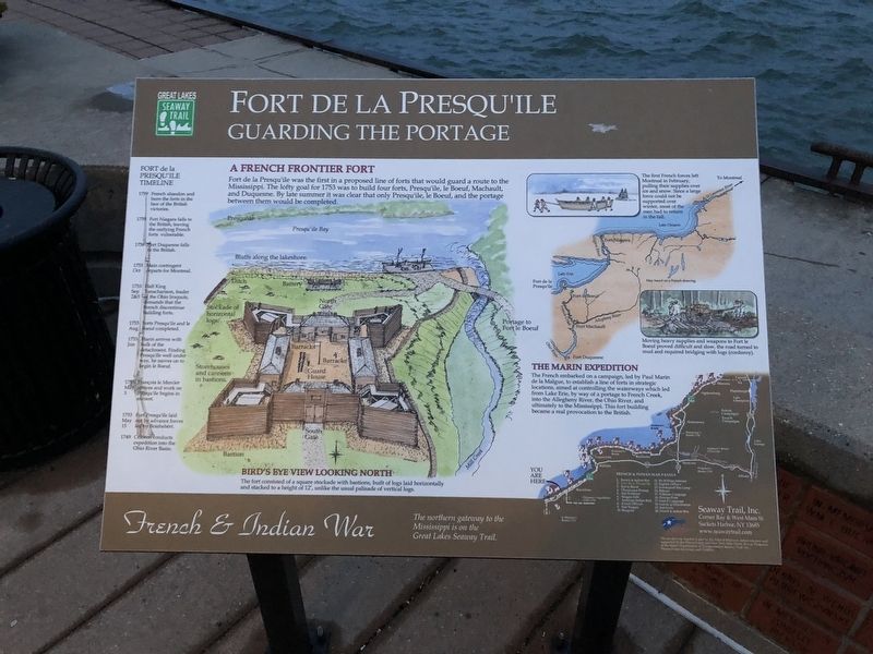
Fort de la Presqu'ile was the first in a proposed line of forts that would guard a route to the Mississippi. The lofty goal for 1753 was to build four ports, Presqu'ile, le Boeuf, Machault, and Duquesne. By the late summer it was clear that only Presqu'ile, le Boeuf, and the portage between them would be completed.
The first French forces left Montreal in February, pulling their supplies over ice and snow. Since a large force could not be supported over winter, most of the men had to return in the fall.
Moving heavy supplies and weapons to Fort le Boeuf proved difficult and slow, the road turned to mud and required bridging with logs (corduroy).
The Marin Expedition
The French embarked on a campaign, led by Paul Marin de la Malgue, to establish a line of forts in strategic locations, aimed at controlling the waterways which led from Lake Erie, by way of a portage to French Creek, into the Allegheny River, the Ohio River, and ultimately to the Mississippi. This fort building became a real provocation to the British.
Bird's Eye View Looking North
The fort consisted of a square stockade with bastions, built of logs laid horizontally and stacked to a height of 12', unlike the usual palisade of vertical logs.
Fort de la Presqu'ile Timeline
1759
French abandon and burn the forts in the face of the British victories.
1759
Fort Niagara falls to the British, leaving the outlying French forts vulnerable.
1758
Fort Duquesne falls to the British.
1753
Oct
Main contingent departs for Montral
1753
Sep
2&3
Half King Tanacharison, leader of the Ohio Iroquois, demands that the French discontinue building forts.
1753
Aug
Forts Presqu'ile and le Boeuf completed.
1753
Jun
Marin arrives with bulk of the detachment. Finding Presqu'ile well under way, he moves on to begin with le Boeuf.
1753
May
3
Françoís le Mercier arrives and work on Presqu'ile begins in earnest.
1753
May
15
Fort Presqu'ile laid out by advance forces led by Boishebért.
1749
Céleron conducts expedition into the Ohio River Basin.
Topics and series. This historical marker is listed in these topic lists: Forts and Castles • Settlements & Settlers • Waterways & Vessels. In addition, it is included in the Great Lakes Seaway Trail National Scenic Byway series list. A significant historical year for this entry is 1753.
Location. 42° 8.316′ N, 80° 5.468′ W. Marker is in Erie, Pennsylvania, in Erie
Other nearby markers. At least 8 other markers are within walking distance of this marker. Alexis de Tocqueville (a few steps from this marker); U.S. Brig Niagara (within shouting distance of this marker); Perry 200 Commemoration (within shouting distance of this marker); Dobbins Landing (within shouting distance of this marker); Captain Daniel Dobbins (about 400 feet away, measured in a direct line); Freshwater Fishing Capital (about 700 feet away); Canal Basin (approx. 0.2 miles away); Making of the Flag "Don't Give Up The Ship" (approx. ¼ mile away). Touch for a list and map of all markers in Erie.
Credits. This page was last revised on March 18, 2019. It was originally submitted on April 16, 2018, by Devry Becker Jones of Washington, District of Columbia. This page has been viewed 334 times since then and 19 times this year. Photos: 1, 2. submitted on April 16, 2018, by Devry Becker Jones of Washington, District of Columbia. • Andrew Ruppenstein was the editor who published this page.

