North Wildwood in Cape May County, New Jersey — The American Northeast (Mid-Atlantic)
Boardwalk
Borough Angelsea 1885 - 1906
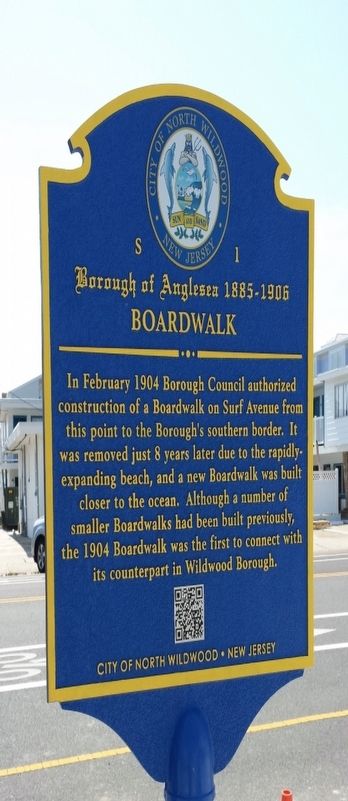
Photographed by Sunny Mancini
1. Boardwalk Marker
Erected 1904 by City of North Wildwood, New Jersey. (Marker Number S1.)
Topics. This historical marker is listed in this topic list: Parks & Recreational Areas. A significant historical month for this entry is February 1904.
Location. 38° 59.781′ N, 74° 47.939′ W. Marker is in North Wildwood, New Jersey, in Cape May County. It is at the intersection of Surf Avenue and 16th Street on Surf Avenue. Touch for map. Marker is in this post office area: Wildwood NJ 08260, United States of America. Touch for directions.

Regionally, this marker is on the Jersey Shore. It is also in the American Northeast, in the Mid-Atlantic, and on the Eastern Seaboard. Globally, it is in the North Atlantic Region, North America, the Western Hemisphere, the Western World, and the Anglosphere. Historically, it finds itself in what was once New Netherland and also one of the original Thirteen Colonies.
Other nearby markers. At least 8 other markers are within walking distance of this marker: A different marker also named Boardwalk (approx. 0.2 miles away); West Jersey and Seashore Railroad (approx. 0.3 miles away); Herefort Inlet Lighthouse (approx. 0.8 miles away); In Honor of Marine Lance Corporal George Dramis (approx. 0.8 miles away); Hereford Inlet Lighthouse (approx. 0.8 miles away); a different marker also named Hereford Inlet Lighthouse (approx. 0.8 miles away); Coast Guard Station Hereford (approx. 0.8 miles away);
this page online
Another marker is no longer nearby. All Shapes, Sizes and Materials (was approx. 0.8 miles away but has been replaced with another marker now near it).
Additional keywords. Boardwalk, North Wildwood
Credits. This page was last revised on November 3, 2022. It was originally submitted on June 11, 2018, by Sunny Mancini of North Wildwood, New Jersey. This page has been viewed 330 times since then and 30 times this year. Photo 1. submitted on June 11, 2018, by Sunny Mancini of North Wildwood, New Jersey. • Bill Pfingsten was the editor who published this page.
