Near Boise in Ada County, Idaho — The American West (Mountains)
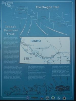
Idaho's Emigrant Trails
The Oregon Trail
In 1843 wagons first rolled past Fort Hall to face the harshness and desolation of the Snake River Plain. Dust, sagebrush, lava rock, mosquitoes, a burning sun, cold nights, and a concerned Native American population made the journey an arduous one. Yet, these pioneers continued on to establish ocean-to-ocean nation.
Prior to the discovery of gold, California-bound emigrants followed the main Oregon Trail to Raft River before turning south on the California Trail. Gold seekers soon opened new routes in an attempt to reach their destinations sooner. Hudspeth's Cutoff (1849) directed traffic west from Soda Springs. The Salt Lake Alternate (Hensley's Cutoff, 1848) enabled travelers to obtain supplies in Salt Lake City before continuing their journey. These routes joined in the City of Rocks area and headed west through Granite Pass.
As the number of emigrants increased, lands along the trail became barren of grass and wood, and water sources often became tainted. Consequently, alternate routes were explored and utilized.
The primary routes of the Oregon and California Trails have been designated national historic trails throughout southern Idaho. To tour the 1869 Kelton Ramp and Oregon Historic Reserve, cross Highway 21 and head to the rim just west of here.
Erected by Ada County Parks and Recreation, Idaho Department of Transportation.
Topics and series. This historical marker is listed in these topic lists: Roads & Vehicles • Settlements & Settlers. In addition, it is included in the Oregon Trail series list.
Location. 43° 32.544′ N, 116° 6.582′ W. Marker is near Boise, Idaho, in Ada County. Marker is at the intersection of State Highway 21 and East Lake Forest Drive, on the right when traveling east on State Highway 21. Touch for map. Marker is in this post office area: Boise ID 83716, United States of America. Touch for directions.
Other nearby markers. At least 8 other markers are within walking distance of this marker. Bonneville Point (a few steps from this marker); Fort Boise (a few steps from this marker); Kelton Road (a few steps from this marker); Ezra Meeker (a few steps from this marker); "Our Road Was Very Steep…" (approx. 0.4 miles away); The Oregon Trail (approx. 0.8 miles away); Beaver Dick's Ferry (approx. 0.8 miles away); Whitman Overlook (approx. 0.9 miles away). Touch for a list and map of all markers in Boise.
More about this marker. This marker is located at Oregon Trail display just off the highway.
Credits. This page was last revised on June 19, 2018. It was originally submitted on June 19, 2018, by Barry Swackhamer of Brentwood, California. This page has been viewed 554 times since then and 52 times this year. Photos: 1, 2. submitted on June 19, 2018, by Barry Swackhamer of Brentwood, California.

