Manzanar National Historic Site near Independence in Inyo County, California — The American West (Pacific Coastal)
A Community's Living Room
Manzanar National Historic Site
Photographed by Craig Baker, April 28, 2023
1. A Community's Living Room Marker
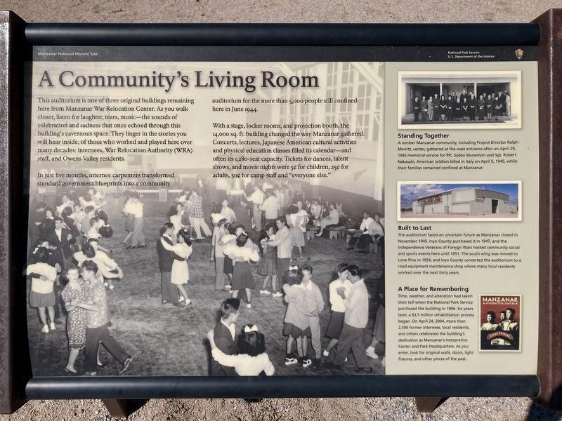
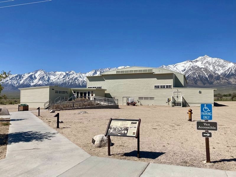
In just five months, internee carpenters transformed standard government blueprints into a community auditorium for more than 5,000 people still confined here in June 1944.
With a stage, locker rooms, and projection booth, the 14,000 sq. ft. building changed the way Manzanar gathered. Concerts, lectures, Japanese American cultural activities and physical education classes filled its calendar---and often its 1,280-seat capacity. Tickets for dances, talent shows, and movie nights were 5 cents for children, 25 cents for adults, 50 cents for camp staff and “everyone else.”
Erected by National Park Service-United States Department of the Interior.
Topics. This memorial is listed
this page online
Location. 36° 43.672′ N, 118° 8.866′ W. Memorial is near Independence, California, in Inyo County. It is in Manzanar National Historic Site. It can be reached from Manzanar Reward Road west of U.S. 395. Touch for map. Memorial is at or near this postal address: 5001 US-395, Independence CA 93526, United States of America. Touch for directions.

Regionally, this memorial is in California’s Sierra Nevada. It is also in the American Mountain West. Globally, it is in North America, on the Ring of Fire, on the Pacific Rim, in the Western Hemisphere, in the Western World, and in the Anglosphere. Historically, it finds itself in what was once New Spain and also Mexico’s Alta California.
Other nearby markers. At least 10 other markers are within walking distance of this marker: Manzanar National Historic Site (within shouting distance of this marker); Manzanar (within shouting distance of this marker); Crowded Quarters (about 500 feet away, measured in a direct line); Block 14 (about 500 feet away);
Photographed by Don Morfe, July 10, 2009
2. A Community's Living Room Marker
Photographed by Craig Baker, April 28, 2023
3. Marker and Visitor Center

Photographed by Don Morfe, July 10, 2009
4. Manzanar Entrance Sign
Photographed by Don Morfe, July 10, 2009
5. Manzanar National Historic Site
Credits. This page was last revised on September 5, 2025. It was originally submitted on December 1, 2013, by Don Morfe of Baltimore, Maryland. This page has been viewed 907 times since then and 26 times this year. Last updated on August 31, 2018, by Craig Baker of Sylmar, California. Photos: 1. submitted on June 15, 2023, by Craig Baker of Sylmar, California. 2. submitted on December 1, 2013, by Don Morfe of Baltimore, Maryland. 3. submitted on June 15, 2023, by Craig Baker of Sylmar, California. 4, 5. submitted on December 1, 2013, by Don Morfe of Baltimore, Maryland. • Andrew Ruppenstein was the editor who published this page.
