Near Tevfikiye in Çanakkale Merkez, Çanakkale, Turkey — West Asia or Southeast Europe
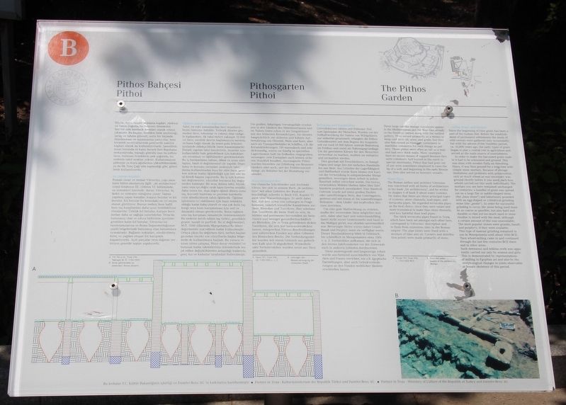
The Pithos Garden
English Text:
These large vat-like storage containers appear in the Mediterranean and Near East already in the Neolithic period along with the earliest pottery. They served primarily as a means to keep cool olive oil, wine, and grain, but they also functioned as transport containers in maritime commerce for such things as pottery. These pithoi were often as tall as a man and had very thick walls. Many examples have no secure means of support because they were commonly half buried in the earth in special storerooms. Pithoi that had gone out of use were sometimes employed to raise the lip of a well, and beginning in the early Bronze age, they also served as funerary vessels.
Water Pipes
The Roman author and architect Vitruvius was concerned with all forms of architecture in his book "De architectura", and he writes in chapter 6 of book 8 about water systems. He states that there are three principal types of systems: stone channels, lead pipes, and terracotta pipes. He regarded terracotta pipes as the best choice, since they were easier and more economical to make than stone channels, and less harmful than lead pipes.
The thick terracotta pipes found in Troia, which have been set amongst each other here, correspond to Vitruvius' description and to finds from numerous sites in the Roman empire. The pipe joints were fixed with a mixture of lime and oil. Corners and distribution points were made primarily of stone.
Grinding Stones and Mortars
Since the beginning of time grain has been a part of the human diet. Before the establishment of permanent settlements the seeds of wild cereals were gathered only occasionally, but with the advent of the Neolithic period, ca. 10,000 years ago, the early types of grain began to play a central role in agriculture and served as the main source of nourishment.
In order to make the harvested grain usable it had to be winnowed and ground. this was done with wooden flails on threshing floors. It was ground than ground for a long time with simple mortars. Because of storage limitations and problems with preservation, only as much wheat as was necessary was ground shortly before it was used, each household carried out this work individually. The mortars you see here remained unchanged for centuries: a handful of grain was spread out on a large flat or saddle-shaped stone (the "base stone") or laboriously pounded with an egg-shaped or cylindrical grinding stone (the "pestle"). In order for successful grinding to occur, the stone being used must be as coarse as possible, but also hard and durable so that not too much sand or stone residue is mixed with the meal, although a certain amount of this
was unavoidable. The most popular stones were granite, basalt, and porphyry, if they were available.
This type of manual grinding remained in use in Mesopotamia until about 1000 BCE. Then wheel-milling came in and continued through the last few centuries BCE there and in other areas.
Such strenuous and tedious work was apparently carried out only by women and girls. This is demonstrated by representations of milling in Egyptian art and also by the morphological changes in joints observable in female skeletons of this period.
Erected by The Ministry of Culture of the Republik of Turkey, and the Daimler-Benz AG. (Marker Number B.)
Topics. This historical marker is listed in these topic lists: Forts and Castles • Parks & Recreational Areas • Settlements & Settlers.
Location. 39° 57.42′ N, 26° 14.416′ E. Marker is near Tevfikiye, Çanakkale, in Çanakkale Merkez. Marker can be reached from Tevfikiye Yolu just west of Izmir Çanakkale Yolu (Highway E87) when traveling west. This marker is located on the grounds of a world famous Archaeological Park. Touch for map. Marker is in this post office area: Tevfikiye, Çanakkale 17100, Turkey. Touch for directions.
Other nearby markers. At least 4 other markers are within walking distance of this marker. The East Wall (within shouting distance of this marker);
The Northern Bastion (about 120 meters away, measured in a direct line); Citadel Wall (about 120 meters away); The Temple of Athena (about 150 meters away).
More about this marker. The present day Archaeological Site of Troy, where this marker is located, has been recognized as a UNESCO World Heritage Centre site.
Also see . . .
1. Archaeological Site of Troy - UNESCO World Heritage Centre. This is a link to additional on-line information regarding this site. (Submitted on September 13, 2018, by Dale K. Benington of Toledo, Ohio.)
2. Troy - Wikipedia. This is a link to additional on-line information regarding this site. (Submitted on September 13, 2018, by Dale K. Benington of Toledo, Ohio.)
3. Archaeological Site of Troy, Unesco | Go Turkey Tourism. This is a link to additional on-line information regarding this site. (Submitted on September 13, 2018, by Dale K. Benington of Toledo, Ohio.)
4. Troy | Turkish Archaeological News. This is a link to additional on-line information regarding this site. (Submitted on September 13, 2018, by Dale K. Benington of Toledo, Ohio.)
Credits. This page was last revised on February 1, 2022. It was originally submitted on September 10, 2018, by Dale K. Benington of Toledo, Ohio. This page has been viewed 157 times since then and 15 times this year. Photos: 1, 2, 3. submitted on September 11, 2018, by Dale K. Benington of Toledo, Ohio.


