Near Waubay in Day County, South Dakota — The American Midwest (Upper Plains)
Potholes and Prairie
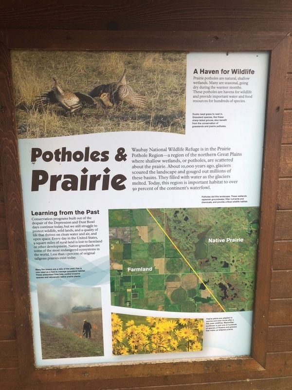
Waubay National Wildlife Refuge is in the Prairie Pothole Region-a region of the northern Great Plains where shallow wetlands, or potholes, are scattered about the prairie. About 10,000 years ago, glaciers scoured the landscape and gouged out millions of these basins. They filled with water as the glaciers melted. Today, this region is important habitat to over 50 percent of the continent's waterfowl.
A Haven for Wildlife
Prairie potholes are natural, shallow wetlands. Many are seasonal, going dry during the warmer months. These potholes are havens for wildlife and provide important water and food resources for hundreds of species.
Picture Inset
Ducks need grass to nest in. Grassland species, like these sharp-tailed grouse, also benefit from the conservation of grasslands and prairie potholes.
Picture Inset
Potholes dot this landscape. These wetlands replenish groundwater, filter nutrients and chemicals, and provide critical wildlife habitat.
Picture inset
Many fire towers are a relic of the past. Fire is now used as a tool to manage grassland habitat. These prescribed fires help control invasive species and rejuvenate native prairie plants.
Picture Inset
Prairie plants are adapted to survive and even thrive after a fire, even wildfires. Maximillian sunflower is just one of hundreds of species of flowers and grasses that make up tallgrass prairie.
Topics. This historical marker is listed in these topic lists: Charity & Public Work • Environment • Natural Features.
Location. 45° 25.524′ N, 97° 19.76′ W. Marker is near Waubay, South Dakota, in Day County. Marker is on Waubay Refuge Entrance Road. The marker is two miles over the causeway from the park entrance off 466th ave. Touch for map. Marker is in this post office area: Waubay SD 57273, United States of America. Touch for directions.
Other nearby markers. At least 8 other markers are within 9 miles of this marker, measured as the crow flies. Saving Men and Beasts (here, next to this marker); A Room with a View (here, next to this marker); Waubay National Wildlife Refuge (about 800 feet away, measured in a direct line); Changes on the Land (approx. ¾ mile away); Waubay Wetland Management District (approx. 1.1 miles away); a different marker also named Waubay National Wildlife Refuge (approx. 1.1 miles away); Chief Bluedog (approx. 2.2 miles away); Roberts County / Day County South Dakota (approx. 8.1 miles away). Touch for a list and map of all markers in Waubay.
Credits. This page was last revised on October 23, 2018. It was originally submitted on October 22, 2018, by Ruth VanSteenwyk of Aberdeen, South Dakota. This page has been viewed 118 times since then and 11 times this year. Photos: 1, 2, 3. submitted on October 22, 2018, by Ruth VanSteenwyk of Aberdeen, South Dakota. • Andrew Ruppenstein was the editor who published this page.


