Monastiraki in Kentrikos Tomeas Athinon, Attica, Greece — Ελλάδα (Southeastern Europe, Balkan Peninsula)
The East Side of the Ancient Agora and the Stoa of Attalos

Photographed By Barry Swackhamer, July 19, 2018
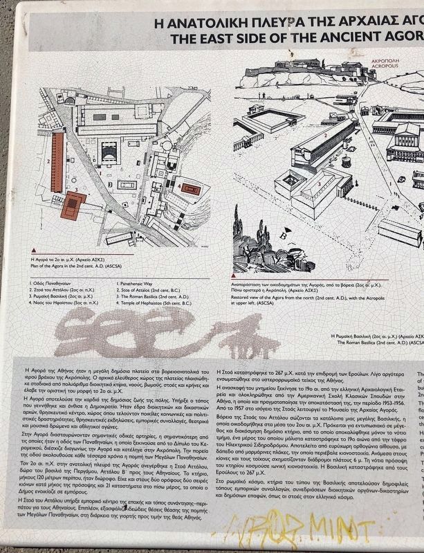
1. The East Side of the Ancient Agora and the Stoa of Attalos Marker, left side
Captions: (upper left) Plan of the Agora in the 2nd cent. A.D., 1. Panatheanaic Way, 2. Stoa of Attalos (2nd cent. B.C.), 3. The Roman Basilica (2nd cent. A.D.), 4. Temple of Hephaistos (5th cent. B.C.); (upper center) Restored view of the Agora from the north (2nd cent. A.D.), why the Acropolis upper left; (lower center) The Roman Basilica (2nd cent. A.D.); (right side, top to bottom) Cutaway model of the Stoa of Attalos, The Stoa of Attalos in 1952, The Stoa of Attalos in 1956.
(Text in Greek on the left side. To read it enlarge the marker image.)
English:
The Ancient Agora of Athens was a large public square northwest of the sacred hill of the Acropolis. The open space was gradually surrounded by many administrative buildings, temples, altars, stoas and fountain houses. It received its final form in the 2nd cent. A.D.
The Agora was the heart of public life in the city. Here democracy was born and flourished. It was the seat of administrative officials and the judiciary, a religious centre and also a place where religious celebrations, commercial transactions, theatrical and musical events and athletic contests took place.
Here important roadways met, the most important being the Panathenaic Way. This extended from the Dipylon in the Kerameikos to the entrance to the Acropolis, cutting diagonally through the central square of the Agora. Along the course of the Panantheanaic Way went the procession of the Great Pananthenaia every four years.
The Stoa of Attalos, a gift of Attalos II, King of Pergamon, to the Athenians was constructed on the east side of the Agora in the 2nd cent. B.C.
The building was 120 m. long and had two floors. It had two series of columns on the interior and 21 shops at the back of both floors, which could be rented by the Deme (township) of Athens to merchants.
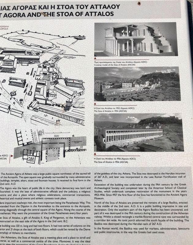
For the Athenians the Stoa of Attalos was a meeting place and a place to stroll and converse, as well as a commercial centre of the time. Moreover, it was the ideal place to view the procession of the Great Pananthenaia during the festival in honor of the goddess of the city, Athena. The Stoa was destroyed in the Herulian incursion of 267 A.D., and later was incorporated in the Late Roman Fortification wall of Athens.
Excavation of the building was undertaken during the 19th century by the Greek Archaeological Society and completed later by the American School of Classical Studies, which undertook complete restoration of the monument in the years 1953-1956. Since 1957 the first floor of the Stoa has functioned as the Ancient Agora Museum.
North of the Stoa of Attalos are preserved the remains of a large Basilica, erected in the middle of the 2nd cent. A.D. It is a public building impressive in size and decoration. Only the southern part of the Agora Basilica has been uncovered, and part of it was destroyed in the 19th century during

Photographed By Barry Swackhamer, July 19, 2018
2. The East Side of the Ancient Agora and the Stoa of Attalos Marker, right side
Captions: (upper left) Plan of the Agora in the 2nd cent. A.D., 1. Panatheanaic Way, 2. Stoa of Attalos (2nd cent. B.C.), 3. The Roman Basilica (2nd cent. A.D.), 4. Temple of Hephaistos (5th cent. B.C.); (upper center) Restored view of the Agora from the north (2nd cent. A.D.), why the Acropolis upper left; (lower center) The Roman Basilica (2nd cent. A.D.); (right side, top to bottom) Cutaway model of the Stoa of Attalos, The Stoa of Attalos in 1952, The Stoa of Attalos in 1956.
In the Roman world, the Basilica was used for markers, administration, lawcourts and public intercourse, in the way the Greeks had used stoas.
Topics. This historical marker is listed in these topic lists: Architecture • Man-Made Features.
Location. 37° 58.555′ N, 23° 43.441′ E. Marker is in Monastiraki, Attica, in Kentrikos Tomeas Athinon. Marker is on Adrianou close to Kinetou, on the left when traveling west. Touch for map. Marker is at or near this postal address: Adrianou 27, Monastiraki, Attica 105 56, Greece. Touch for directions.
Other nearby markers. At least 8 other markers are within walking distance of this marker. Stoa of Attalos (159-138 B.C.) (within shouting distance of this marker); Odeion of Agrippa and Gymnasium or "Palace of the Giants" (about 120 meters away, measured in a direct line); The Library of Pantainos (about 150 meters away); Temple of Apollo Patroos, Temple of Zeus Pharatrios and Athena Phratria, Benches or "Synedrion" (about 150 meters away); Church of the Holy Apostles (ca. A.D. 1000) (about 210 meters away); Temple of Hephaistos
(about 210 meters away); Water Clock (about 210 meters away); The House on Panos Street (approx. 0.3 kilometers away). Touch for a list and map of all markers in Monastiraki.
Credits. This page was last revised on March 21, 2022. It was originally submitted on November 11, 2018, by Barry Swackhamer of Brentwood, California. This page has been viewed 189 times since then and 22 times this year. Photos: 1, 2, 3. submitted on November 11, 2018, by Barry Swackhamer of Brentwood, California.
