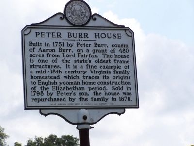
Near Kearneysville in Jefferson County, West Virginia — The American South (Appalachia)
Peter Burr House
Erected 1982 by West Virginia Department of Culture and History.
Topics and series. This historical marker is listed in these topic lists: Colonial Era • Settlements & Settlers. In addition, it is included in the West Virginia Archives and History series list. A significant historical year for this entry is 1751.
Location. 39° 21.422′ N, 77° 51.617′ W. Marker is near Kearneysville, West Virginia, in Jefferson County. Marker is at the intersection of War Admiral Boulevard (West Virginia Route 9) and W. Burr Road, on the right when traveling south on War Admiral Boulevard. Marker is on a side road paralleling new WV9. Touch for map. Marker is at or near this postal address: 147 E Burr Blvd, Kearneysville WV 25430, United States of America. Touch for directions.
Other nearby markers. At least 8 other markers are within 2 miles of this marker, measured as the crow flies. Peter Burr / William Burr Houses (about 500 feet away, measured in a direct line); Hockensmith Apple Storage Building (approx. 0.4 miles away); The Greenback Raid (approx. half a mile away); Valley View / Tackley Farm (approx. 0.9 miles away); Gap View Farm (approx. one mile away); York Hill (approx. 1.6 miles away); General William Darke (approx. 1.8 miles away); a different marker also named General William Darke (approx. 1.8 miles away). Touch for a list and map of all markers in Kearneysville.
Credits. This page was last revised on January 21, 2022. It was originally submitted on October 18, 2008, by Bill Pfingsten of Bel Air, Maryland. This page has been viewed 2,334 times since then and 21 times this year. Photo 1. submitted on October 18, 2008, by Bill Pfingsten of Bel Air, Maryland.
