Chimney Rock in Rutherford County, North Carolina — The American South (South Atlantic)
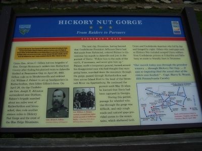
Hickory Nut Gorge
From Raiders to Pursuers
— Stoneman's Raid —
On March 24, 1865, Union Gen. George Stoneman led 6,000 cavalrymen from Tennessee into southwestern Virginia and western North Carolina to disrupt the Confederate supply line by destroying sections of the Virginia and Tennessee Railroad, the North Carolina Railroad, and the Piedmont Railroad. He struck at Boone on March 28, headed into Virginia on April 2, and returned to North Carolina a week later. Stoneman's Raid ended at Asheville on April 26, the day that Confederate Gen. Joseph E. Johnston surrendered to Union Gen. William T. Sherman near Durham.
Union Gen. Alvan C. Gillem led two brigades of Gen. George Stoneman's raiders into Rutherford County after finding his planned route to Asheville blocked at Swannanoa Gap on April 20, 1865. Gillem rode on to Hendersonville and ordered Col. William J. Palmer to set up headquarters in Rutherfordton, then follow Gillem's force. On April 26, the day Confederate Gen. Joseph E. Johnston surrendered near Durham, Palmer's brigade marched about ten miles west of Rutherfordton and bivouacked, then rode another sixteen miles to Hickory Nut Gorge and the crest of the Blue Ridge Mountains.
The next day, St6oneman, having learned that Confederate President Jefferson Davis had fled south from Richmond, ordered Palmer to discontinue his march to Asheville and join in the pursuit of Davis: "Follow him to the ends of the earth, if necessary, and never give him up."
Palmer, made a temporary general, turned around his disappointed men who had thought they were going home, marched down the mountain through the gorge, passed through Rutherfordton and then across Island Ford to the head of the Savannah River via Spartanburg. He continued the pursuit until May 15 when he learned that Davis had been captured in Georgia.
During this period, passage for wheeled vehicles through the gorge was difficult, and only rough roads and natural gaps provided access to the mountains, which sheltered both Union and Confederate deserters who hid by day and foraged by night. Others who used gaps such as Hickory Nut included escaped Union soldiers from Confederate prisons at Columbia and Salisbury en route to friendly lines in Tennessee.
"Our March today was through the grandest scenery … through Hickory Nut Gap. … It was so imposing that the usual chat of the riders was hushed." - Capt. Harry K. Weand, 15th Pennsylvania Cavalry.
Erected by North Carolina Civil War Trails.
Topics and series. This historical marker is listed in this topic list: War, US Civil. In addition, it is included in the North Carolina Civil War Trails series list. A significant historical date for this entry is March 24, 1865.
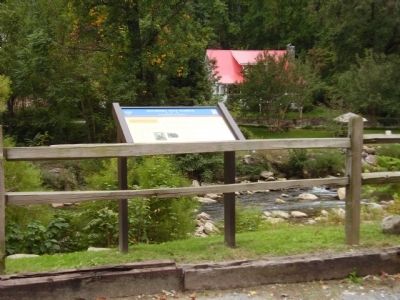
Location. 35° 26.251′ N, 82° 14.47′ W. Marker is in Chimney Rock, North Carolina, in Rutherford County. Marker is on East Main Street (U.S. 74). Touch for map. Marker is in this post office area: Chimney Rock NC 28720, United States of America. Touch for directions.
Other nearby markers. At least 8 other markers are within 6 miles of this marker, measured as the crow flies. Barbara T. Meliski Park (approx. 0.3 miles away); Chimney Rock (approx. 0.4 miles away); The Legacy of Chimney Rock Park (approx. 0.6 miles away); A Real Workhorse (approx. 0.6 miles away); In Commemoration (approx. 0.6 miles away); The 1927 Lake Lure Inn (approx. 0.8 miles away); a different marker also named Chimney Rock (approx. 1.4 miles away); Ayr (approx. 5˝ miles away). Touch for a list and map of all markers in Chimney Rock.
More about this marker. In the lower center of the marker is a portrait of Gen. Alvan C. Gillem. Beside that portrait is a photo of several Federal officers, including Col. William J. Palmer who led the pursuit of Jefferson Davis. On the lower right is a map showing the Route of Stoneman's Raid in Tennessee, Virginia, and North Carolina, March-April 1865.
Credits. This page was last revised on February 25, 2024. It was originally submitted on October 23, 2008, by Stanley and Terrie Howard of Greer, South Carolina. This page has been viewed 1,660 times since then and 31 times this year. Photos: 1, 2, 3, 4. submitted on October 23, 2008, by Stanley and Terrie Howard of Greer, South Carolina. • Craig Swain was the editor who published this page.


