Near Baldwin in Baltimore County, Maryland — The American Northeast (Mid-Atlantic)
Gunpowder Manor
Long Green Valley
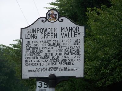
Photographed by Beverly Pfingsten, July 29, 2007
1. Gunpowder Manor – Long Green Valley Marker
Erected 1999 by Maryland Historical Trust, Maryland State Highway Administration.
Topics and series. This historical marker is listed in this topic list: Colonial Era. In addition, it is included in the Maryland Historical Trust series list.
Location. 39° 29.689′ N, 76° 28.196′ W. Marker is near Baldwin, Maryland, in Baltimore County. It is at the intersection of Pleasantville Road and Fork Road / Baldwin Mill Road, on the right on Pleasantville Road. At the intersection, if going south, Pleasantville Road becomes Long Green Pike. Touch for map. Marker is in this post office area: Baldwin MD 21013, United States of America. Touch for directions.

Regionally, this marker is in the Baltimore Metro Region and in Central Maryland. It is also in the American Mid-Atlantic, in the Chesapeake Bay Region, and
this page online
Other nearby markers. At least 8 other markers are within 5 miles of this marker, measured as the crow flies: St. John the Evangelist Catholic Church (approx. 0.6 miles away); Fork United Methodist Church (approx. 1.9 miles away); Ishmael Day’s House (approx. 3.2 miles away); Maj. Gen. Isaac Ridgeway Trimble, C.S.A. (approx. 3.6 miles away); “Quinn” (approx. 3.7 miles away); St. John's Chapel (approx. 4 miles away); Saint John’s Parish (approx. 4.2 miles away); Veterans Memorial (approx. 4.2 miles away).
More about this marker. A marker with identical text was first erected here by the State Rods Commission in 1954. It was replaced by the Maryland Historical Society in 1969. The present marker may be another replacement.
Credits. This page was last revised on December 21, 2024. It was originally submitted on July 29, 2007, by Bill Pfingsten of Bel Air, Maryland. This page has been viewed 4,847 times since then and 191 times this year. Last updated on February 13, 2019, by Carl Gordon Moore Jr. of North East, Maryland. Photo 1. submitted on July 29, 2007, by Bill Pfingsten of Bel Air, Maryland.
