Waikiki in Honolulu in Honolulu County, Hawaii — Hawaiian Island Archipelago (Pacific Ocean)
Kālia Bay
— Waikīkī Historic Trail —
Fish were easily netted from the ponds near Pi‘inaio Stream.
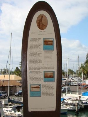
In ancient times, the area was home to many Hawaiian families, who enjoyed the offerings in its bountiful waters. It was not unusual to see native men and women fishing, diving, and gathering seaweed here. Originally, the Pi‘inaio was Waikīkī’s third stream, which entered the ocean here where the ‘Ilikai Hotel now stands. Unlike the Kuekaunahi and ‘Apuakēhau streams, the mouth of the Pi‘inaio was a large, muddy delta intersected by several small tributary channels. These three streams fed a natural irrigation system that supported taro fields, fishponds, and migrant waterfowl. After the arrival of the Chinese in the 19th century, rice fields and duckponds were added. The word ‘Ilikai literally means “the surface of the sea,” a fitting tribute to an area where the ocean was filled with fish, eels, shrimp, lobster, octopus, crab, and limu (seaweed). The fishermen of Kālia caught so much that they became known as “human fishnets.”
As recently as the 1930s, residents of Kālia described the area as “one of the most productive seafood producing bays ever known.” In season, they would see thousands of white crabs on the beach and catch them easily by the bucket full. After the inevitable development of this area, the abundant fishponds and reefs of the old Kālia beach settlement, like the simple Hawaiian lifestyle practiced by its residents, are nostalgic memories. The Paoa‘ohana (family) were well-known residents of the Kālia district, the most famous member being Duke Paoa Kahanamoku, who grew up to be the world’s greatest swimmer. His teenage years were spent in this area, where he practiced the skills that would lead him to the Olympics.
“The whole distance to the village of Whyteete (Waikīkī) is taken up with innumerable artificial fish ponds extending a mile inland from shore. In these the fish taken by net from the sea are put, and though most of the ponds are fresh water, yet the fish seem to thrive and fatten.” —Andres Bloxam, naturalist on the H.M.D. Blonde, 1828.
Erected by Vision Team of Kapahulu, Diamond Head, and Waikiki. (Marker Number 17.)
Topics. This historical marker is listed in these topic lists: Animals • Asian Americans • Sports • Waterways & Vessels. A significant historical year for this entry is 1828.
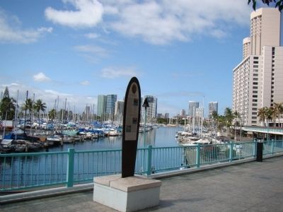
Location. 21° 17.017′ N, 157° 50.347′ W. Marker is in Honolulu, Hawaii, in Honolulu County. It is in Waikiki. Marker can be reached from Holomoana Street south of Ala Moana Boulevard. Marker is on the promenade of the famous Ilikai Hotel and Apartments, one level above the street, overlooking the Ala Wai Boat Harbor. Touch for map. Marker is at or near this postal address: 1777 Ala Moana Blvd, Honolulu HI 96815, United States of America. Touch for directions.
Other nearby markers. At least 8 other markers are within walking distance of this marker. Rainbow Mural (about 400 feet away, measured in a direct line); Rainbow Tower & Hilton Lagoon (about 600 feet away); Duke Kahanamoku (approx. 0.2 miles away); The Story of Kālia (approx. 0.2 miles away); Kaha ha ʻlo me nā Makani (approx. 0.2 miles away); Kuroda Field (approx. 0.3 miles away); Fort DeRussy (approx. 0.4 miles away); Kălia Fishponds (approx. 0.4 miles away). Touch for a list and map of all markers in Honolulu.
More about this marker. Four photographs are reproduced on the marker. The first, at the top of the marker is captioned with the first line of the inscription. The second is captioned, “Cressaty Cottages pier provided a restful spot for fishing and relaxation. It was near the Pierpoint Hotel, which later became the Niumalu and eventually the Hilton Hawaiian Village.” The third is captioned “Hawaiian women gathering limu (seaweed) at low tide was once a common sight in Waikiki.” The fourth reads “The Mochizuki Teahouse was a popular nightspot on the beach nearby. The pipe extending into the ocean
carried coral landfill to shore.”
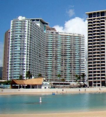
Regarding Kālia Bay. The Ilikai, as the 1960s hotel and condominium building is known, was popularized by the opening credits of the Hawaii 5-0 television show that premiered in 1968.
Also see . . .
1. Tracking Down Ala Wai History. 2008 column by Ray Pendleton in the Honolulu Star-Bulletin. (Submitted on October 29, 2008.)
2. Duke Paoa Kahinu Mokoe Hulikohola Kahanamoku Website. “Years of surfing, rough-water swimming and canoe paddling as a boy and then as a young man molded Duke Kahanamoku into a superb athlete. ‘He had glistening white teeth, dark shining eyes, and a black mane of hair that he liked to toss about in the surf,’ wrote [biographer Grady] Timmons. ‘He stood six feet one and weighed 190 pounds. He had long sinewy arms and powerful legs. He had the well-defined upper body that all great watermen possess, his “full-sail” shoulders tapering down to a slim waist and a torso that was “whipcord” tight.’ As impressive as the rest of his body was, his hands and feet were extraordinary. A veteran Outrigger Canoe Club member remembered that Duke’s hands were so large that when he scooped up ocean water and threw it at you in fun, it looked like a whole bucket of water coming your way.” (Submitted on October 30, 2008.)

Photographed By J. J. Prats, October 20, 2008
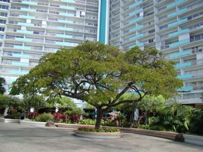
4. The Chinn Ho Tree in the Patio of the Ilikai
A plaque at the base of ther tree reads “This monkeypod tree was planted by Chinn Ho, founder and original owner of the Ilikai. The Chinn Ho tree was rededicated in 1994 in celebration of the 30th anniversary of the Ilikai.”
Additional keywords. Waikiki beach, Kalia Bay, Piinaio Stream, Apuakehau stream, Native Hawaiians, Pacific Islanders
Credits. This page was last revised on February 10, 2023. It was originally submitted on October 29, 2008, by J. J. Prats of Powell, Ohio. This page has been viewed 1,883 times since then and 25 times this year. Photos: 1, 2, 3. submitted on October 29, 2008, by J. J. Prats of Powell, Ohio. 4. submitted on November 1, 2008, by J. J. Prats of Powell, Ohio.


