Near Milledgeville in Baldwin County, Georgia — The American South (South Atlantic)
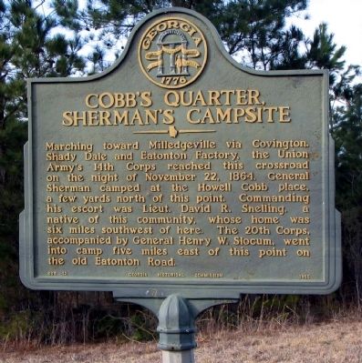
Cobb's Quarter, Sherman's Campsite
Erected 1956 by Georgia Historical Commission. (Marker Number 005-12.)
Topics and series. This historical marker is listed in this topic list: War, US Civil. In addition, it is included in the Georgia Historical Society, and the Sherman’s March to the Sea series lists. A significant historical date for this entry is November 22, 1837.
Location. 33° 7.262′ N, 83° 23.075′ W. Marker is near Milledgeville, Georgia, in Baldwin County. Marker is at the intersection of Old Monticello Road NW and Nelson Road, on the right when traveling west on Old Monticello Road NW. Touch for map. Marker is in this post office area: Milledgeville GA 31061, United States of America. Touch for directions.
Other nearby markers. At least 8 other markers are within 10 miles of this marker, measured as the crow flies. Howell Cobb Plantation (here, next to this marker); Blountsville (approx. 5.7 miles away); a different marker also named Blountsville (approx. 5.7 miles away); The Baptist Church of Christ at Ramoth (approx. 6.8 miles away); Flannery O'Connor's Andalusia Farm (approx. 7 miles away); Junction of 20th and 14th Corps (approx. 7.1 miles away); Brown-Stetson-Sanford House (approx. 9.1 miles away); Route of the Twentieth Corps (approx. 9.2 miles away). Touch for a list and map of all markers in Milledgeville.
Credits. This page was last revised on June 16, 2016. It was originally submitted on October 30, 2008, by David Seibert of Sandy Springs, Georgia. This page has been viewed 2,557 times since then and 55 times this year. Photo 1. submitted on October 30, 2008, by David Seibert of Sandy Springs, Georgia. • Craig Swain was the editor who published this page.
Editor’s want-list for this marker. A wide shot of the marker and its surroundings. • Can you help?
