San Felipe, Guanajuato, Mexico — The Central Highlands (North America)
The Founding of San Felipe, Guanajuato
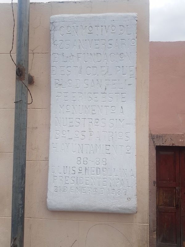
Inscription.
H. Ayuntamiento 86-88
C. Luis O. Medellin A. Presidente Mpal.
21 de enero de 1987
On the occasion of the 425th anniversary of the foundation of this city, the people of San Felipe erect this monument to our national symbols.
Honorable City Hall of 86-88
Luis O. Medellin A., Municipal President, January 21, 1987
Erected 1987 by Honorable Ayuntamiento de San Felipe, 1986-1988.
Topics. This historical marker is listed in these topic lists: Colonial Era • Settlements & Settlers. A significant historical date for this entry is January 21, 1987.
Location. 21° 28.525′ N, 101° 12.958′ W. Marker is in San Felipe, Guanajuato. Marker is on Venustiano Carranza just north of Calle de Arguello, on the right when traveling north. Touch for map. Marker is in this post office area: San Felipe GTO 37600, Mexico. Touch for directions.
Other nearby markers. At least 8 other markers are within walking distance of this marker. Plaza Aquiles Serdán (within shouting distance of this marker); Hidalgo's Priesthood in San Felipe (approx. 0.3 kilometers away); Hidalgo's Proclamation of Independence (approx. 0.4 kilometers away); Miguel Hidalgo in San Felipe (approx. 0.4 kilometers away); 1936 San Felipe Massacre (approx. 0.4 kilometers away); José Práxedis Gilberto Guerrero Hurtado (approx. 0.4 kilometers away); Benito Juárez in San Felipe (approx. 0.4 kilometers away); The Route of Hidalgo (approx. 1.2 kilometers away). Touch for a list and map of all markers in San Felipe.
Credits. This page was last revised on April 12, 2019. It was originally submitted on April 12, 2019, by J. Makali Bruton of Accra, Ghana. This page has been viewed 495 times since then and 52 times this year. Photos: 1, 2, 3, 4. submitted on April 12, 2019, by J. Makali Bruton of Accra, Ghana.


