Gettysburg in Adams County, Pennsylvania — The American Northeast (Mid-Atlantic)
Round Top Branch of the Gettysburg & Harrisburg Railroad
Inscription.
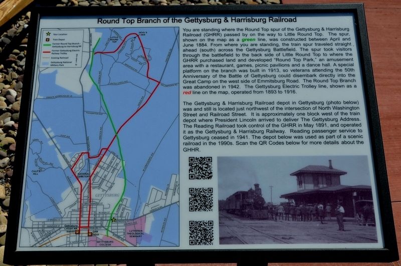
You are standing where the Round Top spur of the Gettysburg & Harrisburg Railroad (GHRR) passed by on the way to Little Round Top. The spur, shown on the map as a green line, was constructed between April and June 1884. From where you are standing, the train spur traveled straight ahead (south) across the Gettysburg Battlefield. The spur took visitors through the battlefield to the back side of Little Round Top to where the GHRR purchased land and developed "Round Top Park," an amusement area with a restaurant, games, picnic pavilions and a dance hall. A special platform on the branch was built in 1913, so veterans attending the 50th Anniversary of the Battle of Gettysburg could disembark directly into the Great Camp on the west side of Emmitsburg Road. The Round Top Branch was abandoned in 1942. The Gettysburg Electric Trolley line, shown as a red line on the map, operated from 1893 to 1916.
The Gettysburg & Harrisburg Railroad depot in Gettysburg (photo below) was and still is located just northwest of the intersection of North Washington Street and Railroad Street. It is approximately one block west of the train depot where President Lincoln arrived to deliver The Gettysburg Address. The Reading Railroad took control of the GHRR in May 1891, and operated it as the Gettysburg & Harrisburg Railway. Reading passenger service to Gettysburg ceased in 1941. The depot below was used as part of a scenic railroad in the 1990s. Scan the QR codes below for more details about the GHRR.
Erected 2019.
Topics and series. This historical marker is listed in these topic lists: Entertainment • Railroads & Streetcars • War, US Civil. In addition, it is included in the Former U.S. Presidents: #16 Abraham Lincoln series list. A significant historical month for this entry is June 1884.
Location. 39° 49.767′ N, 77° 14.3′ W. Marker is in Gettysburg, Pennsylvania, in Adams County. Marker is on West Middle Street (Pennsylvania Route 116) west of Plank Alley, on the left when traveling west. Touch for map. Marker is at or near this postal address: 300 West Middle Street, Gettysburg PA 17325, United States of America. Touch for directions.
Other nearby markers. At least 8 other markers are within walking distance of this marker. Stevens Run Environmental Stewardship (within shouting distance of this marker); 26th Pennsylvania Emergency Infantry (about 700 feet away, measured in a direct line); The Gettysburg Post Office and the Civil War (approx. 0.2 miles away); Chambersburg Pike to the Lincoln Highway (approx. 0.2 miles away); Franklin Street “Colored” School 1884-1932 (approx. 0.2 miles away); Agricultural Hall (approx. 0.2 miles away); The Stevens Log House
(approx. 0.2 miles away); C.W. Hoffman House (approx. ¼ mile away). Touch for a list and map of all markers in Gettysburg.
Credits. This page was last revised on April 28, 2019. It was originally submitted on April 26, 2019, by Karl Stelly of Gettysburg, Pennsylvania. This page has been viewed 356 times since then and 49 times this year. Photos: 1, 2. submitted on April 26, 2019, by Karl Stelly of Gettysburg, Pennsylvania. • Bernard Fisher was the editor who published this page.

