Cumberland Township near Gettysburg in Adams County, Pennsylvania — The American Northeast (Mid-Atlantic)
Sixth U.S. Cavalry
Reserve Brigade - First Division - Cavalry Corps
| — | Army of the Potomac | — |
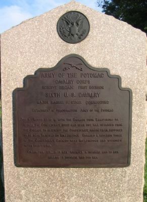
Photographed by Craig Swain, September 17, 2008
1. Sixth U.S. Cavalry Tablet
Cavalry Corps
Reserve Brigade First Division
Sixth U.S. Cavalry
Major Samuel H. Starr Commanding
Detachment at Headquarters Army of the Potomac
July 3 Moved at 12 m. with the Brigade from Emmitsburg to attack the Confederate right and rear but was detached from the Brigade to intercept the Confederate wagon train supposed to be near Fairfield or Millerstown. Engaged a superior force of the Confederate Cavalry near Millerstown and withdrew after heavy loss.
Casualties killed 6 men, wounded 5 officers and 23 men.
Missing 6 officers and 203 men.
Erected 1907 by Gettysburg National Military Park Commission.
Topics. This historical marker is listed in this topic list: War, US Civil. A significant historical month for this entry is July 1826.
Location. 39° 46.522′ N, 77° 15.852′ W. Marker is near Gettysburg, Pennsylvania, in Adams County. It is in Cumberland Township. It is on Emmitsburg Road (Business U.S. 15), on the right when traveling north. Located on the South Cavalry Battlefield section of Gettysburg National Military Park. Touch for map. Marker is in this post office area: Gettysburg PA 17325, United States
this page online

Regionally, this marker is in South-Central Pennsylvania. It is also in the American Northeast, in the Mid-Atlantic, in Appalachia, and specifically in Northern Appalachia. Globally, it is in North America, the Western Hemisphere, the Western World, and the Anglosphere. Historically, it finds itself in what was once the Haudenosaunee (Iroquois) Confederacy and also one of the original Thirteen Colonies.
Other nearby markers. At least 8 other markers are within walking distance of this marker: Position of the Reserve Brigade (a few steps from this marker); Reserve Brigade (a few steps from this marker); Battery K, First U.S. Artillery (about 300 feet away, measured in a direct line); First U.S. Cavalry (about 300 feet away); Second U.S. Cavalry (about 400 feet away); 1st & 2d Regiments United States Cavalry (about 800 feet away); Houghtelin Farmhouse (approx. ¼ mile away); 6th Pennsylvania Cavalry (approx. 0.3 miles away). Touch for a list and map of all markers in Gettysburg.
Also see . . . Samuel Star. Major Starr had a reputation as a strict disciplinarian, as discussed in
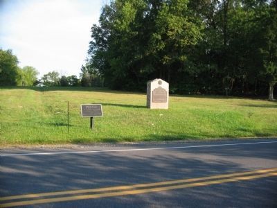
Photographed by Craig Swain, September 17, 2008
2. South Cavalry Field
This often overlooked section of the Gettysburg battlefield includes several Tablets detailing the activities of the Cavalry of the Army of the Potomac, securing the left flank on Emmitsburg Road. Next to the 6th Cavalry tablet is a position marker for the Reserve Brigade.
Credits. This page was last revised on February 7, 2023. It was originally submitted on November 8, 2008, by Craig Swain of Leesburg, Virginia. This page has been viewed 1,179 times since then and 22 times this year. Photos: 1, 2. submitted on November 8, 2008, by Craig Swain of Leesburg, Virginia.
