Cumberland Township near Gettysburg in Adams County, Pennsylvania — The American Northeast (Mid-Atlantic)
First U.S. Cavalry
Reserve Brigade - First Division - Cavalry Corps
| — | Army of the Potomac | — |
Photographed by Craig Swain, September 17, 2008
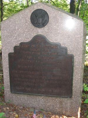
1. First U.S. Cavalry Tablet
Cavalry Corps
Reserve Brigade First Division
First U.S. Cavalry
Captain Robert S. C. Lord commanding
Detachment at Headquarters Army of the Potomac
July 3 Moved with the Brigade at 12 m under Brig. General W. Merritt from Emmitsburg and attacked the Confederate right and rear and was engaged for four hours until the action was brought to a close by a heavy rain.
Casualties Killed 1 man. Wounded 9 men. Missing 5 men.
Erected 1907 by Gettysburg National Military Park Commission.
Topics. This historical marker is listed in this topic list: War, US Civil. A significant historical month for this entry is July 1736.
Location. 39° 46.47′ N, 77° 15.845′ W. Marker is near Gettysburg, Pennsylvania, in Adams County. It is in Cumberland Township. It can be reached from Emmitsburg Road (Business U.S. 15), on the right when traveling north. Located on the South Cavalry Battlefield section of Gettysburg National Military Park. A residential road runs behind the tablet location, but it is best reached by way of a foot path from the pull off on Emmitsburg Road. Touch for map. Marker is in this post office area: Gettysburg PA
this page online

Regionally, this marker is in South-Central Pennsylvania. It is also in the American Northeast, in the Mid-Atlantic, in Appalachia, and specifically in Northern Appalachia. Globally, it is in North America, the Western Hemisphere, the Western World, and the Anglosphere. Historically, it finds itself in what was once the Haudenosaunee (Iroquois) Confederacy and also one of the original Thirteen Colonies.
Other nearby markers. At least 8 other markers are within walking distance of this marker: Second U.S. Cavalry (within shouting distance of this marker); Reserve Brigade (about 300 feet away, measured in a direct line); Battery K, First U.S. Artillery (about 300 feet away); Sixth U.S. Cavalry (about 300 feet away); Position of the Reserve Brigade (about 300 feet away); 1st & 2d Regiments United States Cavalry (approx. 0.2 miles away); Houghtelin Farmhouse (approx. ¼ mile away); 6th Pennsylvania Cavalry (approx. 0.4 miles away). Touch for a list and map of all markers in Gettysburg.
Photographed by Craig Swain, September 17, 2008
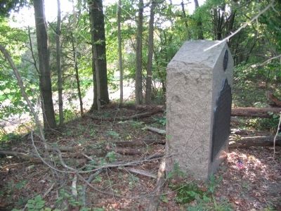
2. First U.S. Cavalry Tablet Location
The tablet is within a stand of trees, almost obscured by heavy underbrush. A residential road passes behind the tablet and is seen in the background.
Photographed by Craig Swain
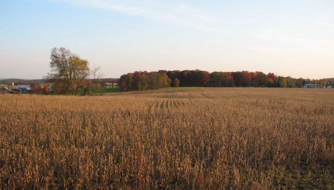
3. Advance of the Regular Cavalry Regiments
Looking north from the South Cavalry Battlefield. Emmitsburg Road is on the right, running past the flagpoles. The US Regulars cavalry regiments in Merritt's Brigade advanced north across these fields toward the far right flank of the Confederate lines. Most of the Brigade deployed to the west of Emmitsburg Road, in the foreground here. The cavalry dismounted prior to advancing, reducing their mobility and effectiveness against the Confederate skirmish line.
Credits. This page was last revised on February 7, 2023. It was originally submitted on November 8, 2008, by Craig Swain of Leesburg, Virginia. This page has been viewed 1,484 times since then and 28 times this year. Photos: 1, 2. submitted on November 8, 2008, by Craig Swain of Leesburg, Virginia. 3. submitted on November 9, 2008, by Craig Swain of Leesburg, Virginia.
