Kingston in Bartow County, Georgia — The American South (South Atlantic)
Woolley's Bridge
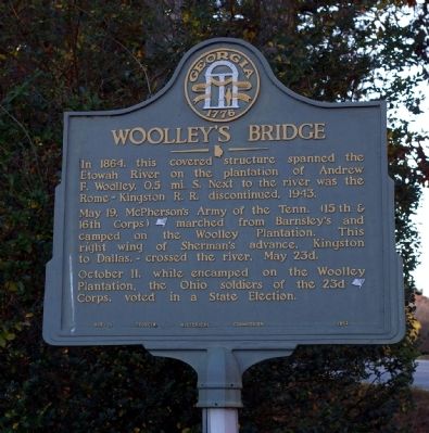
Photographed by David Seibert, November 9, 2008
1. Woolley's Bridge Marker
May 19, McPherson's Army of the Tenn. (15th & 16th Corps) [US] arched from Barnsley's and camped on the Woolley Plantation. This right wing of Sherman's advance, Kingston to Dallas, -- crossed the river, May 23d.
October 11, while encamped on the Woolley Plantation, the Ohio soldiers of the 23d [US] Corps, voted in a State Election.
Erected 1952 by Georgia Historical Commission. (Marker Number 008-11.)
Topics and series. This historical marker is listed in these topic lists: Bridges & Viaducts • War, US Civil. In addition, it is included in the Georgia Historical Society series list. A significant historical year for this entry is 1864.
Location. 34° 14.278′ N, 84° 59.422′ W. Marker is in Kingston, Georgia, in Bartow County. It is at the intersection of Kingston Highway (Georgia Route 293) and Roberson Road, on the left when traveling west on Kingston Highway. Touch for map. Marker is in this post office area: Kingston GA 30145, United States
this page online

Regionally, this marker is in the Mountains. It is also in the American South and specifically in the Deep South. Globally, it is in North America, the Western Hemisphere, the Western World, and the Anglosphere. Historically, it finds itself in what was once the original Cherokee Nation, the territory of the Mississippian Culture, one of the original Thirteen Colonies, one of the Confederate States of America, and the Antebellum South.
Other nearby markers. At least 8 other markers are within 3 miles of this marker, measured as the crow flies: The Federal Army at Kingston (approx. 2.2 miles away); Hardee's Corps at Kingston (approx. 2.2 miles away); Spring Bank (approx. 2.2 miles away); House - Site Thomas V. B. Hargis (approx. 2½ miles away); The Andrews Raiders at Kingston (approx. 2½ miles away); Rome Railroad (approx. 2½ miles away); Melvinia Shields (approx. 2½ miles away); Queen Chapel Methodist Church Cemetery (approx. 2½ miles away). Touch for a list and map of all markers in Kingston.
Regarding Woolley's Bridge. The bridge is no longer standing.
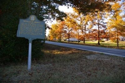
Photographed by David Seibert, November 9, 2008
2. Woolley's Bridge Marker
Credits. This page was last revised on March 11, 2019. It was originally submitted on November 28, 2008, by David Seibert of Sandy Springs, Georgia. This page has been viewed 2,267 times since then and 55 times this year. Photos: 1, 2. submitted on November 28, 2008, by David Seibert of Sandy Springs, Georgia. • Craig Swain was the editor who published this page.
