
Near Cavendish in Queens County, Prince Edward Island — The Atlantic Provinces (North America)
Cavendish Dunelands Trail/Cavendish Sentier Dunelands
Cavendish and Tourism/Cavendish et le tourisme
Photographed by Steve Stoessel, August 22, 2019
1. Cavendish and Tourism Marker

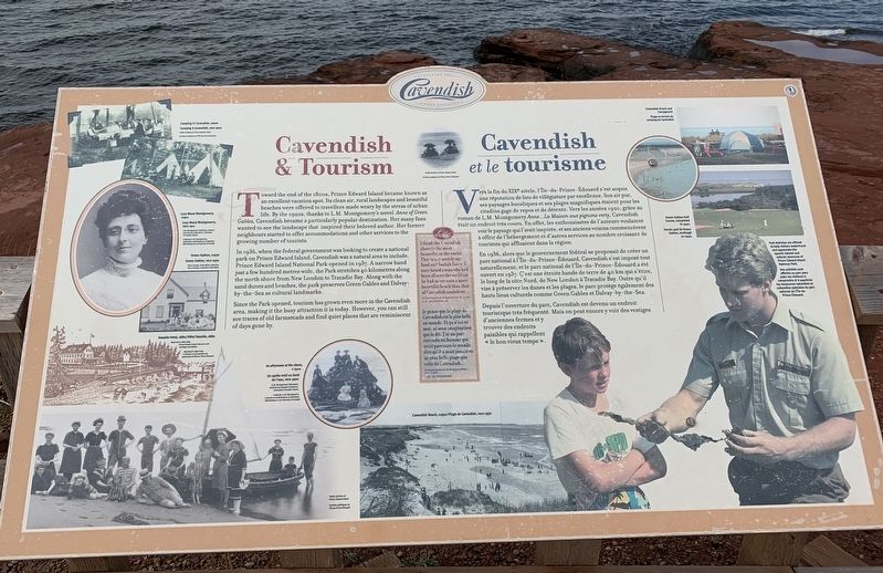
Toward the end of the 1800s, Prince Edward Island became known as an excellent vacation spot. Its clean air, rural landscapes and beautiful beaches were offered to travellers made weary by the stress of urban life. By the 1920s, thanks to L.M. Montgomery's novel Anne of Green Gables, Cavendish became a particularly popular destination. Her many fans wanted to see the landscape that inspired their beloved author. Her former neighbours started to offer accommodations and other services to the growing number of tourists.
In 1936, when the federal government was looking to create a national park on Prince Edward Island, Cavendish was a natural area to include. Prince Edward Island National Park opened in 1937. A narrow band just a few hundred metres wide, the Park stretches 40 kilometres along the north shore from New London to Tracadie Bay. Along with the sand dunes and beaches, the park preserves Green Gables and Dalvay-by-the-Sea as cultural landmarks.
Since the Park opened, tourism has grown even more in the Cavendish area, making it the busy attraction it is today. However, you can still see traces of old farmsteads
this page online
En 1936, alors que le gouvernement fédéral se proposait de créer un parc national à l'île-du-Prince-Édouard, Cavendish s'est imposé tout naturellement, et le parc national de l'Ile-du-Prince-Edouard a été 1937. C'est une étroite bande de terre de 40 km qui s'étire, le long de la côte Nord, de New Lóndon à Tracadie Bay. Outre qu'il vise à préserver les dunes et les plages, le parc protège également des hauts lieux culturels comme Green Gables et Dalvay-by-the-Sea.
Depuis l'ouverture
Photographed by Steve Stoessel
2. Cavendish and Tourism Marker
Center Inset: L.M. Montgomery’s thoughts on the Cavendish Shoreline:
The Selected Journals of L.M. Montgomery Vol. 1, May 24, 1908 L.M. Montgomery
The Selected Journals of L.M. Montgomery Vol. 1, May 24, 1908 L.M. Montgomery
Topics. This historical marker is listed in these topic lists: Arts, Letters, Music • Industry & Commerce • Parks & Recreational Areas. A significant historical year for this entry is 1936.
Location. 46° 29.945′ N, 63° 22.846′ W. Marker is near Cavendish, Prince Edward Island, in Queens County. It can be reached from Terre Rouge Lane. Touch for map. Marker is in this post office area: Cavendish PE C0A 1M0, Canada. Touch for directions.

Regionally, this marker is in Central Coastal P. E. I. It is also in the Maritimes and in Atlantic Canada. Globally, it is in the North Atlantic Region, North America, the Western Hemisphere, the Western World, and the Anglosphere. Historically, it finds itself in what was once a British colony, the Viceroyalty of New France, and Acadia.
Other nearby markers. At least 8 other markers are within 10 kilometers of this marker, measured as the crow flies: History of the Cavendish Area / Histoire de la région de Cavendish. (about 120 meters away, measured in a direct line); a different marker also named Cavendish Dunelands Trail/Cavendish Sentier Dunelands (about 120 meters away); a different marker also named Cavendish Dunelands Trail/Cavendish Sentier Dunelands (about 120 meters away); Lucy Maud Montgomery (approx. 1.2 kilometers away); North Rustico War Memorial (approx. 6.8 kilometers away); The Village of North Rustico (approx. 7.5 kilometers away); Rev. John Geddie D.D. (approx. 9.6 kilometers away); Springbrook World War II Memorial (approx. 9.7 kilometers away). Touch for a list and map of all markers in Cavendish.
Credits. This page was last revised on September 13, 2019. It was originally submitted on September 11, 2019, by Steve Stoessel of Niskayuna, New York. This page has been viewed 270 times since then and 10 times this year. Photos: 1, 2. submitted on September 11, 2019, by Steve Stoessel of Niskayuna, New York. • Andrew Ruppenstein was the editor who published this page.
