Capernaum in Mevo'ot HaHermon Regional Council, Northern District, Israel — West Asia (the Levant in the Middle East)
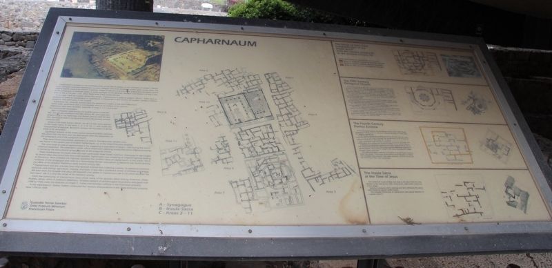
Capharnaum
In the year 1668 the traveler Michel Nau wrote: "Capharnaum is called at present Talhum." Kefar Nahum, rendered in Greek as Capharnaum or Capernaum, is mentioned in first century AD sources, namely in Flavius Josephus, and particularly in the Gospels.
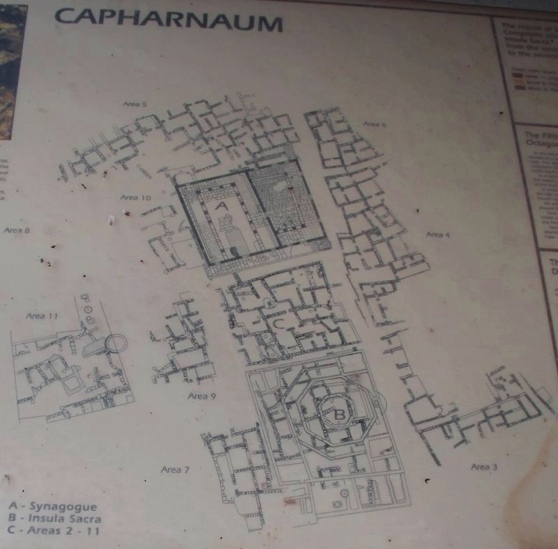
Excavation has, however, pushed back the settlement's origins to the third millennium. Some walls, pavements and a considerable amount of pottery of the second millennium have been recorded, especially in areas n. 9-11 and under the monumental synagogue.
After a complete break during the Israelite period (1200-587 BC), the site was resettled in the 5th century BC, and expanded progressively in the Hellenistic and Roman periods (300 BC-300 AD), reaching its peak in the Byzantine period (fourth-early seventh centuries AD).
Strata of the Early Roman Period (63 BC-70 AD) were reached in the Insula Sacra, in the areas n. 3, 7, 9, 10, 11 and under the monumental synagogue. Byzantine remains are abundant in all the areas so far excavated.
Significant remains of the Arabic period (seventh-twelfth centuries AD) prove that the town was not abandoned after the destruction of the synagogue and of the octagonal church.
They were found everywhere, particularly in area 8. Post-Byzantine remains were also found in the eastern part of ancient Capharnaum, i.e. in the Greek-Orthodox property.
The ruins cover an area of approximately 6 ha. suggesting a population of about 1,500 during the town's maximum expansion. The settlement's center, which reveals town planning during that period of great prosperity, is marked by the monumental synagogue and of the octagonal church.
These contemporary structures share the main north-south street (cardo maximus), intersected at right angles by several alleys (decumani) that form small quarters. Capharnaum was crossed by an imperial highway leading to Damascus. Most probably the highway bypassed the northern flank of Capharnaum; in fact some 100 meters northeast of the synagogue and close to a monumental Roman mausoleum a milestone was found bearing the name of the emperor Hadrianus (early second century AD).
Capharnaum was also a border town that received
revenue from collecting customs. Its additional economic resources were fishing, agriculture, industry, and trade. It was also a prominent center of Christian pilgrimage. We learn from the gospels that Jesus left Nazareth and settled in Capharnaum (Matthew 4:12) which became "his own town" (Matthew 9:1) and the center of his messianic activity.
From the community of Capharnaum Jesus chose many of his apostles either among fishermen (Peter, Andrew, James, John) or publicans (Matthew). Nineteen seasons of archaeological excavations took place from 1968 to 1986 under the direction of Virgilio C. Corbo and Stanislao Loffreda in the Franciscan property.
In the meantime Dr. Vasilios Tzaferis conducted four seasons of excavations in the Greek-Orthodox propertyfrom 1978 to 1984.
The House of Saint Peter
Composite plan of the Insula Sacra from the second century BC to the seventh century AD
Three main levels of occupation are shown:
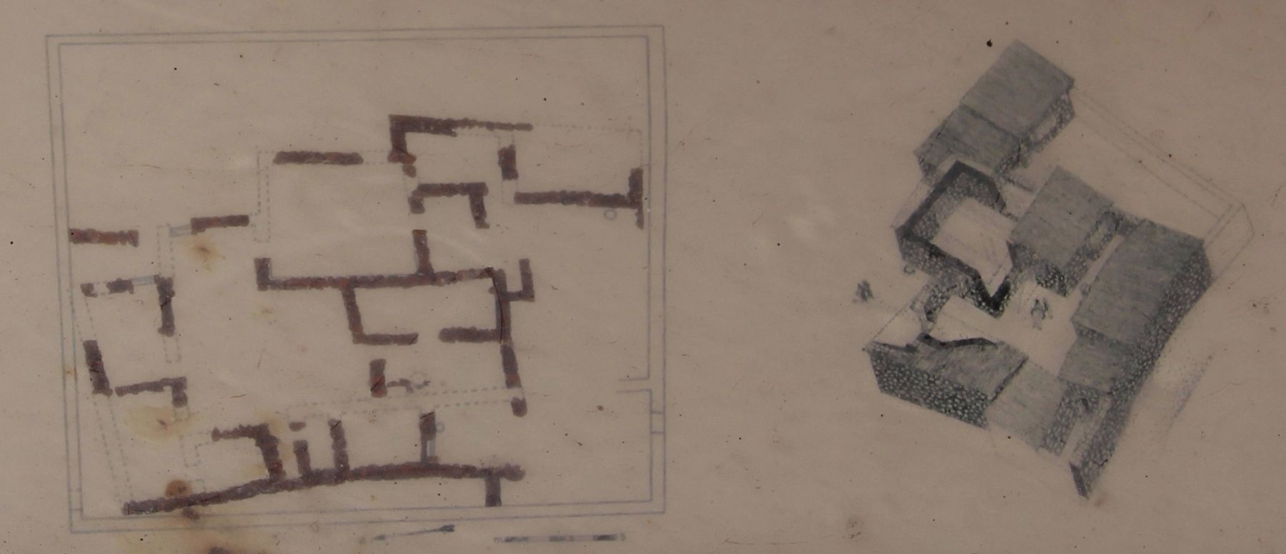
Level 1: original layout of private houses.
Level 2: fourth century Domus Ecclesia
Level 3: fifth century Octagonal Church
The Fifth Century
Octagonal Church
In the second half of the fifth century an octagonal church was erected on a raised level within the perimeter of the previous enclosure wall. The plan consisted of a small central octagon, of a larger

Photographed By Dale K. Benington, April 5, 2019
3. Capharnaum Marker
Close-up view, that is displayed in the upper right of the marker, of both the illustrated overhead view that maps out the archaeological ruins of the House of Peter, from the 2nd century BC to the 7th century AD, along with a photograph of the ruins, taken prior to the construction of the overhead, present day, chapel.
In a second phase a baptismal font was added in the middle of the eastern apse. Some rooms were also built along the south flank of the enclosure wall.
In order to keep alive the memory of Peter's House, buried under the new mosaic floor; the Byzantines built the central octagon of their church right over the walls of the venerated room.
An anonymus pilgrim of Piacenza passing through Capharnaum around 560-570, writes about this final transformation.
"And so we came on to Capharnaum to the house of Saint Peter, which is now a basilica." Probably the church was destroyed during the Persian invasion in the early seventh century.
Several Middle Ages structures were built in the area of the abandoned church. The modern Memorial upon the House of Saint Peter was dedicated on June 29 1990.
The Fourth Century
Domus Ecclesia
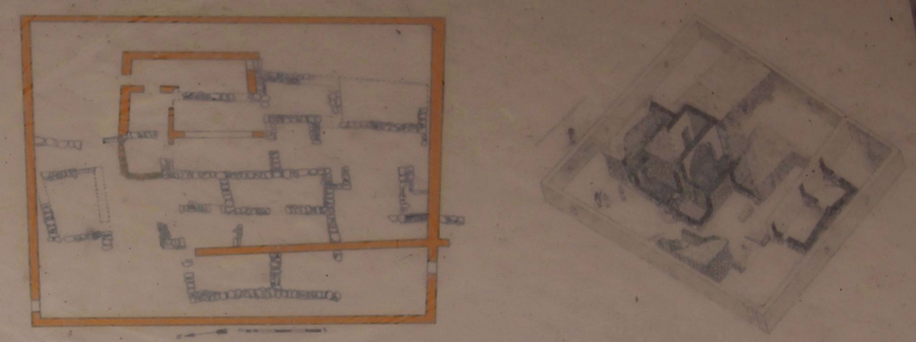
In the late fourth century AD one special room (1) of St. Peter House measuring 5.80 by 6.45 meters, became a Domus Ecclesia, i.e. was used for religious gatherings.
In the fourth century the traditional House of Peter was set apart from the rest of the town through the construction of an enclosure wall encompassing a perimeter of 112.55

Photographed By Dale K. Benington, April 5, 2019
4. Capharnaum Marker
Close-up view, that is displayed in the middle upper right of the marker, of both the illustrated overhead view that maps out the archaeological ruins of the Fifth Century Octagonal Church, along with an illustration of the reconstructed view of the Octagonal Church.
This Domus Ecclesia is referred to by Eteria in the late fourth century when she writes: "The house of the prince of the Apostles (i.e. Peter) was changed into a church. The walls, however, (of that house) are still standing as they were (originally)."
The Insula Sacra
at the Time of Jesus
The traditional house of Peter was close to the lake shore and was flanked to the east by the main , north-south, road (cardo maximus) of the village.
Spacious courtyards with a staircase and terra refractaria fire places were shared by several roofed rooms.
The Christian community of Capharnaum paid special attention to a square room (1).
Erected by Custodia Terrae Sanctae Ordo Fratrum Minorum Franciscan Friars.
Topics. This historical marker is listed in these topic lists: Anthropology & Archaeology • Churches & Religion • Settlements & Settlers. A significant historical date for this entry is June 29, 1990.
Location. 32° 52.834′ N, 35° 34.515′ E. Marker is in Capernaum, Northern District, in Mevo'ot HaHermon Regional Council. Marker can be reached from Northern District Route 87, 16.7 kilometers east of Northern District Route 90, on the right when traveling east. This historical marker is located in The Capernaum National Park,
Photographed By Dale K. Benington, April 5, 2019
5. Capharnaum Marker
Close-up view, that is displayed in the middle lower right of the marker, of both the illustrated overhead view that maps out the archaeological ruins of the Fourth Century Domus Ecclesia (room used for religious gatherings), along with an illustration of the reconstructed view of the Domus Ecclesia.
Other nearby markers. At least 8 other markers are within walking distance of this marker. The House of Peter (here, next to this marker); The Memorial Church of St. Peter (a few steps from this marker); a different marker also named Capharnaum (a few steps from this marker); The Synagogue of Capharnaum (a few steps from this marker); Excavations in Capharnaum (within shouting distance of this marker); The Synagogue of Jesus (within shouting distance of this marker); Sea of Galilee (within shouting distance of this marker); a different marker also named Capharnaum (about 90 meters away, measured in a direct line). Touch for a list and map of all markers in Capernaum.
More about this marker. The archaeological site that this marker describes is extremely significant in the New Testament, Biblical record. The village of Capharnaum (also know as Capernaum) is mentioned in the scriptural record 16 times: Matthew 4:13; Matthew 8:5; Matthew 11:23; Matthew 17:24; Mark 1:21; Mark 2:1; Mark 9:33; Luke 4:23; Luke 4:31; Luke 7:1; Luke 10:15; John 2:12; John 4:46; John 6:17; John 6:24; and John 6:59. Peter's house is specifically mentioned in the scriptural record, in Matthew 8:14, where it states: "When Jesus came into Peter’s home, He saw his mother-in-law
Photographed By Dale K. Benington, April 5, 2019
6. Capharnaum Marker
Close-up view, that is displayed in the lower right of the marker, of both the illustrated overhead view that maps out the archaeological ruins of the First Century AD Insula Sacra (House of Peter), along with an illustration of the reconstructed view of the Insula Sacra (House of Peter).
So this marker, marks the site, where for centuries, countless Christian pilgrims have come to visit the site where both the Apostle Peter had lived, and where Jesus Christ had at the very least visited, and perhaps extended His stay there for several years.

Photographed By Dale K. Benington, March 8, 2013
8. Capharnaum Marker
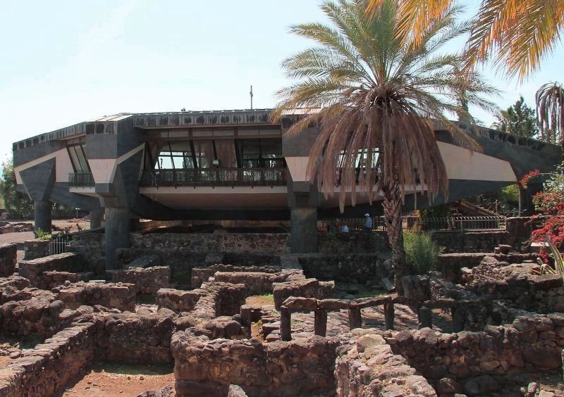
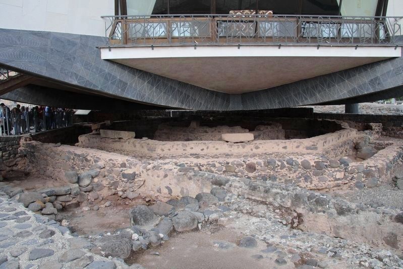
Panoramic view of the featured marker (far left of picture) along with the view of the archaeological ruins of the First Century House of Peter, seen under the later ruins of the 5th Century Byzantine Octagonal Church, with a view of the underside of the present day structure of an overhead church chapel.
Photographed By Dale K. Benington, April 5, 2019
9. 1st Century House of Peter / 5th Century Byzantine Octagonal Church
A more distant view of the archaeological ruins of the First Century House of Peter, seen under the later ruins of the 5th Century Byzantine Octagonal Church, with a view of the underside of the present day structure of an overhead church chapel.
Credits. This page was last revised on September 25, 2019. It was originally submitted on September 11, 2019, by Dale K. Benington of Toledo, Ohio. This page has been viewed 171 times since then and 6 times this year. Photos: 1, 2, 3, 4, 5, 6, 7, 8, 9. submitted on September 24, 2019, by Dale K. Benington of Toledo, Ohio.
