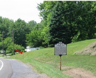
Millwood in Clarke County, Virginia — The American South (Mid-Atlantic)
Signal Station
Topics and series. This historical marker is listed in this topic list: War, US Civil. In addition, it is included in the Virginia Department of Historic Resources (DHR) series list.
Location. Marker has been reported missing. It was located near 39° 1.06′ N, 77° 57.916′ W. Marker was in Millwood, Virginia, in Clarke County. Marker was on John Mosby Highway (U.S. 50). Touch for map. Marker was in this post office area: Millwood VA 22646, United States of America. Touch for directions.
Other nearby markers. At least 8 other markers are within 5 miles of this location, measured as the crow flies. Ashby’s Gap (here, next to this marker); Clark County / Fauquier County (approx. 0.3 miles away); Jackson’s Bivouac (approx. 1.2 miles away); Mt. Carmel Fight (approx. 1.3 miles away); Mount Bleak Farm (approx. 1.8 miles away); Fight at Berry's Ferry (approx. 2.9 miles away); Vinyard Fight (approx. 3½ miles away); Lee Moves North Again (approx. 4.3 miles away). Touch for a list and map of all markers in Millwood.
More about this marker. THIS MARKER IS MISSING. Only the post remains.
Also see . . . Mosby Heritage Area Tour. An old photo of the marker is shown on this Civil War Album page. (Submitted on June 27, 2007, by Craig Swain of Leesburg, Virginia.)
Credits. This page was last revised on June 16, 2016. It was originally submitted on June 27, 2007, by Craig Swain of Leesburg, Virginia. This page has been viewed 1,906 times since then and 24 times this year. Photos: 1, 2. submitted on June 27, 2007, by Craig Swain of Leesburg, Virginia. • J. J. Prats was the editor who published this page.
Editor’s want-list for this marker. Do you have a photo of the missing marker you could upload? • Can you help?

