Near North Riverfront in St. Louis, Missouri — The American Midwest (Upper Plains)
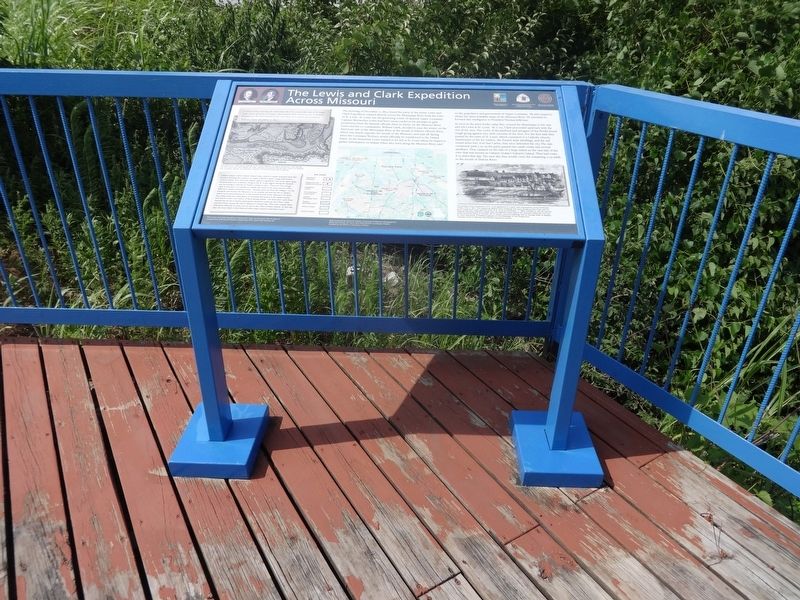
The Lewis and Clark Expedition Across Missouri

Photographed by Jason Voigt, July 7, 2017
1. The Lewis and Clark Expedition Across Missouri Marker
"a Verry rainey morning the wind from the N, E, crossed the river to St. Louis, Capt. Lewis detain for to acquire information of the Countrey and to prepare Despatches to the government by the next Mail. At 11oClock I proceeded on..."
William Clark, December 11, 1803
The morning of December 11, 1803, found the party of the future Lewis and Clark Expedition camped directly across the Mississippi River from the town of St. Louis. St. Louis was the governing center of Spanish Upper Louisiana. Captain Meriwether Lewis had been unsuccessful in his attempts to gain permission from the Spanish officials there to winter on the Missouri River. Lewis and his co-commander, William Clark, decided to pass the winter on the American side of the Mississippi River at the mouth of DuBois (Wood) River, which was nearly opposite the mouth of the Missouri, and wait till Spring when the Louisiana Territory would officially be transferred to the United States. In the meantime Lewis wanted to be left at St. Louis where he hoped to gather information on Indian tribes who lived along the Missouri River, and on the population and government
this page online
As soon as the party broke camp they crossed the Mississippi in the rain and left Lewis at St. Louis. At 11 P.M., Clark proceeded upstream with the rest of the men. The crews of the keelboat and pirogues of the flotilla found rough going against very swift currents of the river. For the first mile they passed by the town of St. Louis, which consisted of a Catholic church, warehouses of the fur traders, 180 French-style dwellings, and the old round stone fort, Fort San Carlos, that once defended the city. The rain continued until 3 P.M. as the party passed two small creeks and several sandbars. They camped on the side of a large island on the east side of the river that was known as Cabaret (today's Gabaret) Island. They had come 6.25 miles that day. The next day they would cover the remaining 11.25 miles to the mouth of DuBois River.
(Caption:)
This detail of a 1796 map by George Victor Collot depicts the region around St. Louis during the time Lewis and Clark passed through. Cabaret and Grande Islands, later known as Gabaret and Chouteau Islands, are depicted. Courtesy of David Rumsey Map Collection.
(Aside:)
Cabaret Island, called Gabaret Island today (which is visible upstream from this location flaking the entrance to Chain of Rocks Canal), along with nearby Grande Island, now Chouteau Island, played a significant role in the open range livestock practices of farmers living in the St. Louis region during the Spanish era. According to Nicolas de Finiels, writing in 1803: "There are not enough cattle in this part of Louisiana to supply the needs of the area, and it is often difficult to obtain subsistence here...Animals graze far from the villages-on the lowlands that border the Missouri, or on Grande Isle and the Isle a Cabaret, which are located between St. Louis and the mouth of the Missouri. On these low, damp lands the cattle graze on horsetail that grows in the shady woods, and which is their sole source of food during winter...[To keep their cattle from wondering too far as winter approaches, farmers] round up all of their cattle and lead them toward the Isle la Cabaret or Grande Isle. Then they compel them with great difficulty to cross over to one or the other of these islands. In this way they are more likely to find them all when time comes to lead them back."
(Caption:)
This earliest known illustration of St. Louis appeared on a bank note engraved by Leney & Rollinson of New York in 1817. This engraving depicts many buildings that were standing when Clark and his party rowed their boats past the town of St. Louis on December 11, 1803. Included on this list was the Auguste Chouteau Mansion (upper left), the Market House (below the Chouteau Mansion), Fort San Carlos (round building on horizon left of center), and the dwellings and fur storage sheds of leading St. Louis merchants. A keelboat appears on the Mississippi in the foreground. Courtesy of Eric P. Newman Numismatic Education Society
Erected by National
Photographed by Jason Voigt, July 7, 2017
2. The Lewis and Clark Expedition Across Missouri Marker
A shot of the marker on the deck, which overlooks the Mississippi River.
Topics and series. This historical marker is listed in these topic lists: Exploration • Waterways & Vessels. In addition, it is included in the Lewis & Clark Expedition series list. A significant historical date for this entry is December 11, 1803.
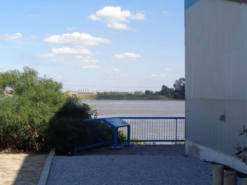
Location. 38° 40.603′ N, 90° 11.455′ W. Marker is in St. Louis, Missouri. It is in Near North Riverfront. It can be reached from St. Louis Riverfront Trail just south of East Prairie Avenue, on the right when traveling south. Marker is located on a deck behind the Mary Meachum Freedom Crossing Rest Area/Visitor's Center, which is located on the North Riverfront Trail. The closest road is East Prairie, which is 0.2 miles from the Rest Area. At the end of East Prairie, there is a parking lot that has access to the Riverfront Trail. Please keep in mind that access to this marker is limited throughout the year, as it is only viewable from April to October, on Thursdays, Fridays and Saturdays during that time. A fence surrounds the Visitor's Center, thus preventing public access to the marker when not
Photographed by Jason Voigt, October 1, 2019
3. The Lewis and Clark Expedition Across Missouri Marker
A view of the marker from the trail (this was behind a fence)

Regionally, this marker is in the American Midwest, in the Lewis & Clark Corridor, in the Corn Belt, and in the Great River Road Region. Globally, it is in North America, the Western Hemisphere, the Western World, and the Anglosphere. Historically, it finds itself in what was once the territory of the Mississippian Culture, the Louisiana Purchase, and the Antebellum South.
Other nearby markers. At least 8 other markers are within 2 miles of this marker, measured as the crow flies: Main Street of America ran right through Venice (approx. 1.1 miles away in Illinois); War Memorial (approx. 1.2 miles away in Illinois); Venice High School Bell (approx. 1.6 miles away in Illinois); Freedom Village (approx. 1.8 miles away in Illinois); Our Story (approx. 1.8 miles away); Murphy-Blair National Historic District (approx. 1.8 miles away); George Boyer Vashon Museum of African American History (approx. 1.9 miles away); St. Louis Place Historic District (approx. 1.9 miles away). Touch for a list and map of all markers in St. Louis.
Other markers no longer nearby. Coast Guard Rest Stop (was within shouting distance of this marker but has been replaced with another marker now near it); Mary Meachum Freedom Crossing (was within shouting distance of this marker but has been confirmed missing).
Also see . . . Lewis and Clark National Historic Trail. (Submitted on October 3, 2019, by Jason Voigt of Glen Carbon, Illinois.)
Credits. This page was last revised on January 30, 2023. It was originally submitted on October 3, 2019, by Jason Voigt of Glen Carbon, Illinois. This page has been viewed 427 times since then and 44 times this year. Photos: 1, 2, 3. submitted on October 3, 2019, by Jason Voigt of Glen Carbon, Illinois. • Devry Becker Jones was the editor who published this page.
