The Driftless Area of Wisconsin
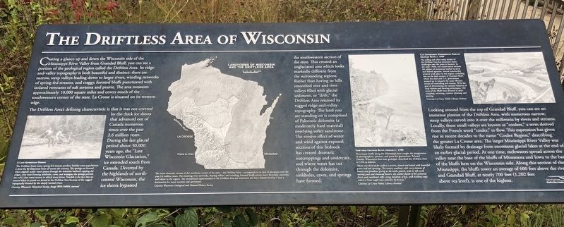
Casting a glance up and down the Wisconsin side of the Mississippi River Valley from Grandad Bluff, you can see a portion of the geological region called the Driftless Area. Its ridge and valley topography is both beautiful and distinct: there are narrow, steep valleys leading down to larger rivers, winding networks of spring fed streams, and craggy, forested bluffs punctuated with isolated remnants of oak savanna and prairie. The area measures approximately 10,000 square miles and covers much of the southwestern corner of the state. La Crosse is situated on its western edge.
The Driftless Area's defining characteristic is that is was not covered by the thick ice sheets that advanced out of Canada numerous times over the past 2.6 million years. During the last glacial period about 30,000 years ago, the "Late Wisconsin Glaciation," ice extended south from Canada. Diverted by the highlands of north central Wisconsin, the ice sheets bypassed the southwestern section of the state. This created an unglaciated area which looks markedly different from the surrounding regions. Rather than having its hills smoothed over and river valleys filled with glacial sediment, or "drift," the Driftless Area retained its rugged ridge-and-valley topography. The land you are standing on is comprised of Paleozoic dolomite (a moderately hard material)
overlying softer sandstone. The erosive effect of water and wind against exposed sections of this bedrock has created dramatic outcroppings and undercuts, and where water has cut through the dolomite, sinkholes, caves, and springs have formed.Looking around from the top of Grandad Bluff, you can see an immense plateau of the Driftless Area, with numerous narrow, steep valleys carved into it over the millennia by rivers and streams. Locally, these small valleys are known as "coulees," a term derived from the French word "couler," to flow. This expression has given rise in recent decades to the name "Coulee Region," describing the greater La Crosse area. The larger Mississippi River Valley was likely formed by drainage from enormous glacial lakes at the end of an earlier glacial period. At one time, meltwaters spread across the valley near the base of the bluffs of Minnesota and Iowa to the base of the bluffs here on the Wisconsin side. Along this section of the Mississippi, the bluffs tower an average of 600 feet above the river and Grandad Bluff, at nearly 700 feet (1,202 feet above sea level) is one of the highest.
The Driftless Area's many spring-fed streams produce healthy trout populations, a draw for fly fishermen from all across the country. The springs are formed when slightly acidic water passes through the dolomite bedrock capping the ridges, over time forming sinkholes, caves, and seepages; the springs provide the cold, clear water source in which trout thrive. Notable is the fact that no natural lakes or ponds are found in the Driftless Area because of the rugged topography formed by the deeply incised rivers.
Courtesy Wisconsin Historical Society Image Whi-94809, reversed.
The more dramatic terrain of the southwest corner of the state - the Driftless Area - corresponds to its lack of glaciation over the past 2.6 million years. The resulting river networks, sloping valleys, and winding, forested bluffs attract many bicyclist, canoeists, and hikers to the region. The recreational opportunitys in the Driftless Area are numerous and have helped develop it into a destination for many tourists and sportsmen.
Courtesy Wisconsin Geological and Natural History Survey
Picturesque bluffs along the Mississippi have caught the imagination of photographers, painters, and poets for generations. Edward Daniels, Wisconsin's first state geologist, described the Driftless Area in 1854 as follows:
"About one-third of the surface is prairie, dotted and belted with beautiful groves and oak openings. The scenery combines with every element of beauty and grandeur, giving us the sunlit prairie, with its soft swell, waving grass and thousand flowers; the somber depths of the primeval forest; and castellated cliffs, rising hundreds of feet, with beetling crags which a Titan might have piled for his fortress."
Courtesy La Crosse Public Library Archives
The rolling and often steep terrain of the Driftless Area has presented many challenges over the years to farmers. In the early 1930s, soil conservation became the subject of numerous studies by local and federal agencies. Several noteworthy projects took place in this region, including one on the back section of Grandad Bluff, where the state and U.S. government teamed up to research the most effective means of controlling soil erosion. With the goal of determining the optimal balances of crop choices and farming techniques, 160 acres of the Bluff were devoted to strip-cropping, terracing, contour plowing, and grazing.
Courtesy La Crosse Public Library Archives
Erected by City of La Crosse, Parks, Recreation & Forestry.
Topics. This historical marker is listed in these topic lists: Entertainment • Industry & Commerce • Parks & Recreational Areas. A significant historical year for this entry is 1900.
Location. 43° 48.726′ N, 91° 12.682′ W. Marker is in La Crosse, Wisconsin, in La Crosse County. Marker is on Bliss Road. Located 1 mile west of the entrance to Grandad Bluff Park. Touch for map. Marker is at or near this postal address: 3071 Bliss Road, La Crosse WI 54601, United States of America. Touch for directions.
Other nearby markers. At least 8 other markers are within walking distance of this marker. Quarrying the Bluffs of La Crosse (here, next to this marker); La Crosse: "A Choice Town" (here, next to this marker); History of Flagpole (within shouting distance of this marker); Grandad Bluff: The Making of a Park (within shouting distance of this marker); First Complete Service of Christian Divine Worship (about 500 feet away, measured in a direct line); Our Lady of Sorrows Chapel (approx. 0.6 miles away); Myrick Park Treewalk (approx. 0.9 miles away); Myrick Park Mounds (approx. one mile away). Touch for a list and map of all markers in La Crosse.
Credits. This page was last revised on October 31, 2019. It was originally submitted on October 30, 2019, by Ruth VanSteenwyk of Aberdeen, South Dakota. This page has been viewed 572 times since then and 46 times this year. Photos: 1, 2. submitted on October 30, 2019, by Ruth VanSteenwyk of Aberdeen, South Dakota. • Mark Hilton was the editor who published this page.

