Pohénégamook in Témiscouata, Québec — Central Canada (French-Canadian)
La frontière canado-américaine / The Canada-USA Border
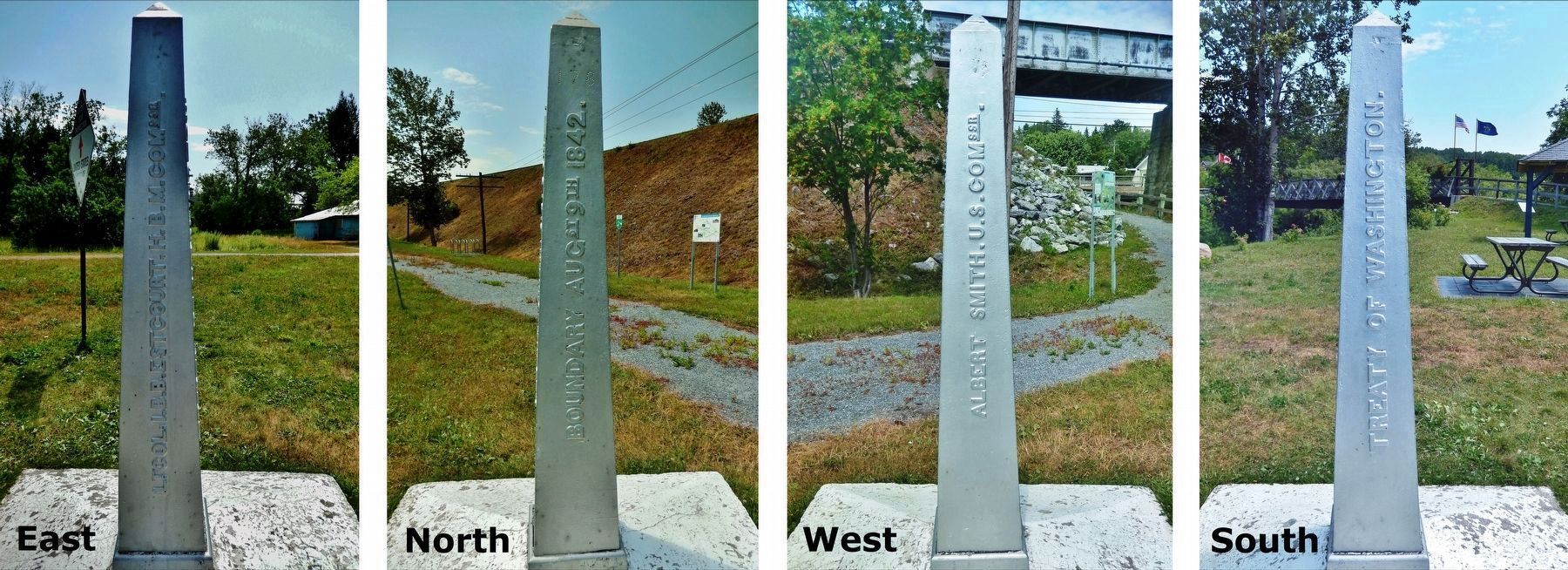
Inscription.
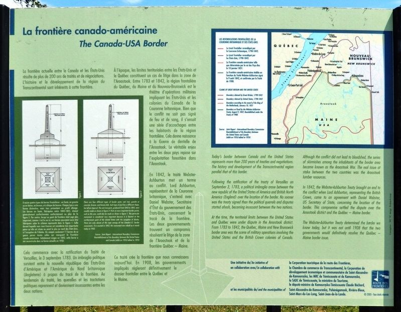
La frontière actuelle entre le Canada et les États-Unis résulte de plus de 200 ans de traités et de négociations. L'histoire et le développement de la région du Transcontinental sont inhérents à cette frontière.
Cela commence avec la ratification du Traité de Versailles, le 3 septembre 1783. Un imbroglio politique survient entre la nouvelle république des États-Unis d'Amérique et l'Amérique du Nord britannique (Angleterre) à propos du tracé de la frontière. Au lendemain du traité, les querelles et les tractations politiques reprennent et deviennent incessantes entre les deux nations.
À l'époque, les limites territoriales entre les États-Unis et le Québec constituent un cas de litige dans la zone de l'Aroostook. Entre 1783 et 1842, la région frontalière du Québec, du Maine et du Nouveau-Brunswick est le théâtre d'opérations militaires impliquant les États-Unis et les colonies du Canada de la Couronne britannique. Bien que le conflit ne soit pas signé de feu et de sang, il s'ensuit une série d'accrochages entre les habitants de la région frontalière. Cela donne naissance à la Guerre de dentelle de l'Aroostook. Le véritable enjeu entre les deux pays repose sur l'exploitation forestière dans l'Aroostook.
En 1842, le traité Webster-Ashburton met un terme au conflit. Lord Ashburton, représentant de la Couronne britannique, s'entend avec Daniel Webster, Secrétaire d'État du gouvernement des États-Unis, concernant le tracé de la frontière. Les deux gouvernements trouvent un compromis résolvant le litige de la zone de l'Aroostook et de la frontière Québec — Maine.
Ce traité crée la frontière que nous connaissons aujourd'hui. En 1908, les gouvernements impliqués régleront définitivement le dossier frontalier entre le Québec et le Maine.
Today's border between Canada and the United States represents more than 200 years of treaties and negotiations. The history and development of the Transcontinental region parallel that of this border.
Following the ratification of the treaty of Versailles on September 3, 1783, a political imbroglio arose between the new republic of the United States of America and British North America (England) over the location of the border. No sooner was the treaty signed than the political quarrels and disputes started afresh, becoming incessant between the two nations.
At the time, the territorial limits between the United States and Quebec were under dispute in the Aroostook
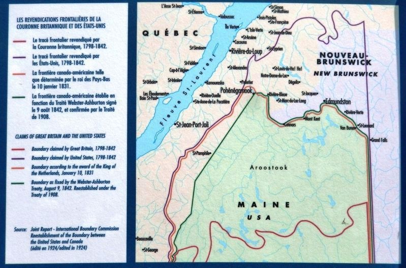
2. Marker detail: Canada-USA Border History
Les Revendications Frontalières de la Couronne Britannique et des États-Unis
• Le tracé frontalier revendiqué par la Couronne britannique, 1798-1842.
• Le tracé frontalier revendiqué par les États-Unis, 1798-1842.
• La frontière canodo-américaine telle que déterminée par le roi des Pays-Bas le 10 janvier 1831.
• La frontière canado-américaine établie en fonction du Traité Webster-Ashburton signé le 9 août 1842, et confirmée par le Traité de 1908.
Claims of Great Britain and the United States
• Boundary claimed by Great Britain, 1798-1842
• Boundary claimed by United States, 1798-1842
• Boundary according to the award of the King of the Netherlands, January 10, 1831
• Boundary as fixed by the Webster-Ashburton Treaty, August 9, 1842. Reestablished under the Treaty of 1908.
Source: Joint Report - International Boundary Commission Reestablishment of the Boundary between the United States and Canada (édité en 1924/edited in 1924)
Although the conflict did not lead to bloodshed, the series of skirmishes among the inhabitants of the border area became known as the Aroostook War. The real issue at stake between the two countries was the Aroostook lumber resources.
In 1842, the Webster-Ashburton Treaty brought an end to the conflict when lord Ashburton, representing the British Crown, came to an agreement with Daniel Webster, US Secretary of State, concerning the location of the border. This compromise settled the dispute over the Aroostook district and the Quebec — Maine border.
The Webster-Ashburton Treaty determined the border we know today, but it was not until 1908 that the two governments would definitively resolve the Quebec — Maine border issue.
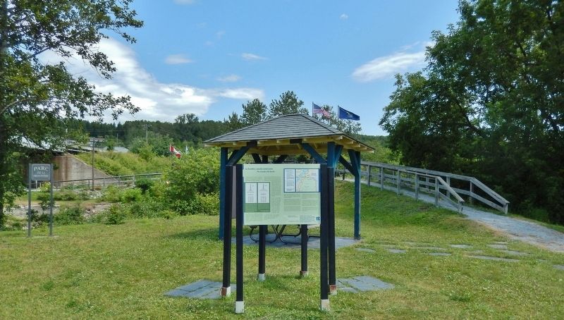
Erected by Route des Frontières, MRC de Témiscouata, and Ville de Pohénégamook.
Topics. This historical marker is listed in this topic list: Political Subdivisions. A significant historical year for this entry is 1842.
Location. 47° 27.572′ N, 69° 13.475′ W. Marker is in Pohénégamook, Québec, in Témiscouata. Marker can be reached from Rue de la Frontière, half a kilometer
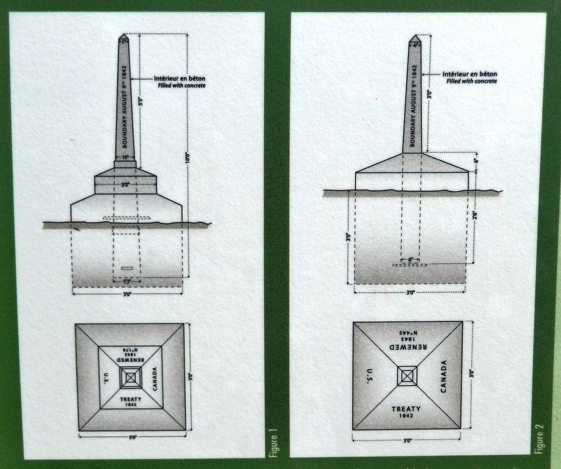
3. Marker detail: Border Post Diagram
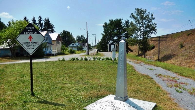
Il existe quatre types de bornes frontalières : en fonte, en granite ou en béton, en bronze, et à disque de bronze. Chaque type a une forme distinctive, mais tous présentent un profil allongé. Les bornes en fonte, fabriquées entre 1843-1845, étaient généralement confectionnées conformément au plan de la figure 2. Par contre, lorsqu'un point de frontière était jugé plus important, comme c'est le cas ici, ces bornes pouvaient aussi être fabriquées selon le schéma représenté dans la figure 1. Celle devant laquelle vous vous trouvez est considérée très importante parce qu'elle est située au point le plus au nord des États-Unis, à l'exception de l'Alaska. On compte seulement 11 bornes de ce genre parmi toutes celles qui marquent la frontière canado-américaine. Initialement érigée en 1843, cette borne a été reconstruite dans sa forme actuelle en 1950.
There are four different types of border posts: cast iron, granite or concrete, bronze, and bronze disk. Each type of post has a different shape, but all are tapered. The cast iron posts, produced from 1843 to 1845 were usually made as shown in figure 2. Posts at more important border points, such as this one, could also be made as shown in figure 1. This particular monument is considered very important because it is located at the northernmost point of the United States with the exception of Alaska. There are only eleven of this type among all the Canada-U.S. border monuments. First erected in 1843, this monument was rebuilt as it stands today in 1950.
Source: Joint Report - International Boundary Commission Reestablishment of the Boundary between the United States and Canada (édité en 1924/edited in 1924)
Other nearby markers. At least 5 other markers are within 14 kilometers of this marker, measured as the crow flies. Le bootlegging dans le Transcontinental / Bootlegging in the Transcontinental Region (here, next to this marker); Le chemin de fer Le Transcontinental / The Transcontinental Railway (here, next to this marker); Le Pont International / The International Bridge (a few steps from this marker); Les Chemins de Fer Du Témiscouata / The Témiscouata Railways (a few steps from this marker); La gare de Rivière-Bleue / The Rivière-Bleue Train Station (approx. 13.8 kilometers away).
Related markers. Click here for a list of markers that are related to this marker. Parc de la frontière (Frontier Park)
Also see . . . Webster-Ashburton Treaty. Daniel Webster and Alexander Baring, First Baron of Ashburton, met in 1842, and the treaty that bears their names not only settled the disputed boundary, but also established a series of agreements on US/British relations. In an attempt to make the shifting borders more palatable in the U.S., Webster produced a map he claimed Benjamin Franklin had made of the region back in the eighteenth century. Webster noted that Franklin's map coincided with the boundaries he had negotiated for the US. This posthumous endorsement of the treaty by a Founding Father of the United States helped the agreement to be ratified by the Senate, though some believe it was a forgery. (Submitted on November 18, 2019, by Cosmos Mariner of Cape Canaveral, Florida.)
Credits. This page was last revised on January 23, 2022. It was originally submitted on November 17, 2019, by Cosmos Mariner of Cape Canaveral, Florida. This page has been viewed 628 times since then and 51 times this year. Photos: 1. submitted on November 17, 2019, by Cosmos Mariner of Cape Canaveral, Florida. 2, 3, 4, 5, 6. submitted on November 18, 2019, by Cosmos Mariner of Cape Canaveral, Florida.
