Waterford in Loudoun County, Virginia — The American South (Mid-Atlantic)
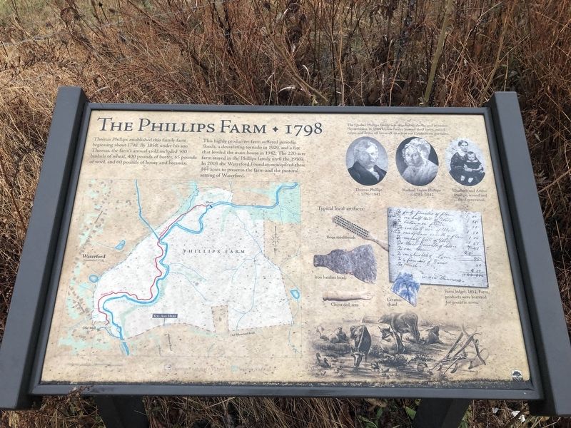
The Phillips Farm
1798
This highly productive farm suffered periodic floods, a devastating tornado in 1929, and a fire that leveled the main house in 1942. The 220-acre farm stayed in the Phillips family until the 1950s. In 2003 the Waterford Foundation acquired these 144 acres to preserve the farm and the pastoral setting of Waterford.
[Captions:]
The Quaker Phillips family was opposed to slavery and secession. Nevertheless, in 1864 Union cavalry burned their barns, seized crops, and drove off livestock to starve out Confederate partisans.
Farm ledger, 1851. Farm products were bartered for goods in town.
Erected by Waterford Foundation.
Topics. This historical marker is listed in these topic lists: Agriculture • Animals • Churches & Religion • Industry & Commerce • War, US Civil. A significant historical year for this entry is 1798.
Location. 39° 11.41′ N, 77° 37.067′ W. Marker is in Waterford, Virginia, in Loudoun County. Marker is at the intersection of Old Wheatland Road (Virginia Route 698) and Milltown Road (Virginia Route 681), on the right when traveling east on Old Wheatland Road. Touch for map. Marker is at or near this postal address: 40024 Old Wheatland Road, Waterford VA 20197, United States of America. Touch for directions.
Other nearby markers. At least 8 other markers are within walking distance of this marker. Mill to Market (here, next to this marker); The Waterford Mill (approx. 0.2 miles away); How it Works (approx. 0.2 miles away); Waterford - An Old Mill Town (approx. 0.2 miles away); Waterford (approx. 0.2 miles away); Independent Loudoun Virginia Rangers (approx. ¼ mile away); Bond Street Barn, Waterford (approx. ¼ mile away); Mutual Fire Insurance Company of Loudoun County (approx. 0.3 miles away). Touch for a list and map of all markers in Waterford.
Credits. This page was last revised on December 1, 2019. It was originally submitted on December 1, 2019, by Devry Becker Jones of Washington, District of Columbia. This page has been viewed 172 times since then and 13 times this year. Photos: 1, 2. submitted on December 1, 2019, by Devry Becker Jones of Washington, District of Columbia.

