Near Port Gibson in Claiborne County, Mississippi — The American South (East South Central)
A Fight at Midnight
Photographed by Cajun Scrambler, November 29, 2019
1. A Fight at Midnight Marker
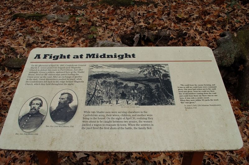
On the afternoon of April 30, 1863, Confederate General Martin E. Green posted his brigade near Magnolia Church to defend this route to Port Gibson. Just after midnight, Green's pickets, stationed here at the Shaifer House, fired on the sixteen-man patrol leading the Union army up the road. After an exchange of gunfire in the dark, Union skirmishers pushed forward, while the Confederates fell back to the ridge behind Magnolia Church, which they held throughout the night.
While two Shaifer men were serving elsewhere in the Confederate army, their wives, children, and mother were living in the house. On the night of April 30, realizing they were about to be caught between two armies, the women packed a wagon to evacuate to town. When the sentries in the yard fired the first shots of the battle, the family fled.
"We could hear the enemy forming, and it was so still we could hear every command given. Our men had orders not to fire until word was given. Soon we could see their line of skirmishers coming down the road and could hear them say there was no one here, it was only a cavalry scout. When they were within 50 yards the word `fire' was given."
Lt. John S. Bell, 12th Arkansas Sharpshooters
Click or scan to see
this page online
Battalion, CSA
Topics. This historical marker is listed in this topic list: War, US Civil. A significant historical date for this entry is April 30, 1863.
Location. 31° 56.857′ N, 91° 2.17′ W. Marker is near Port Gibson, Mississippi, in Claiborne County. It is on Shaifer Road 1½ miles west of Bessie Weathers Road, on the right when traveling west. Touch for map. Marker is at or near this postal address: Shaifer Road, Port Gibson MS 39150, United States of America. Touch for directions.

Regionally, this marker is in Southwest Mississippi, in Natchez Trace Corridor, and in Greater Jackson. It is also in the American South, specifically in the Deep South, and in the Great River Road Region. Globally, it is in North America, a Gulf of Mexico state, the Western Hemisphere, the Western World, and the Anglosphere. Historically, it finds itself in what was once New Spain, the territory of the Mississippian Culture, one of the Confederate States of America, and the Antebellum South.
Other nearby markers. At least 8 other markers are within walking distance of this marker: Battle of Port Gibson
Photographed by Cajun Scrambler, November 29, 2019
2. A Fight at Midnight Marker
Credits. This page was last revised on March 3, 2026. It was originally submitted on December 20, 2019, by Cajun Scrambler of Assumption, Louisiana. This page has been viewed 587 times since then and 30 times this year. Photos: 1, 2. submitted on December 20, 2019, by Cajun Scrambler of Assumption, Louisiana.
