Near Schoharie in Schoharie County, New York — The American Northeast (Mid-Atlantic)
Schoharie County
Right in the Heart of New York
| — | Schoharie County | — |
Photographed by Steve Stoessel, December 29, 2019
1. Schoharie County Marker
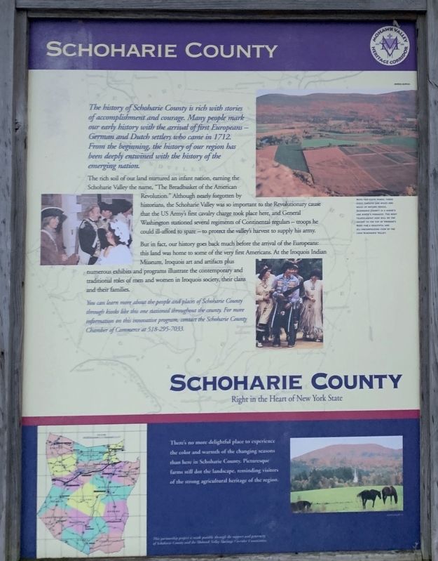
The history of Schoharie County is rich with stories of accomplishment and courage. Many people mark our early history with the arrival of first Europeans -- German and Dutch settlers who came in 1712. From the beginning, the history of our region has been deeply entwined with the history of the emerging nation.
The rich soil of our land nurtured an infant nation, earning the Schoharie Valley the name, "The Breadbasket of the American Revolution.” Although nearly forgotten by historians, the Schoharie Valley was so important to the Revolutionary cause that the US Army's first cavalry charge took place here, and General Washington stationed several regiments of Continental regulars - troops he could ill-afford to spare - to protect the valley's harvest to supply his army.
But in fact, our history goes back much before the arrival of the Europeans: this land was home to some of the very first Americans. At the Iroquois Indian Museum, Iroquois art and artifacts plus numerous exhibits and programs illustrate the contemporary and traditional roles of men and women in Iroquois society, their clans and their families.
You can
this page online
There's no more delightful place to experience the color and warmth of the changing seasons than here in Schoharie County. Picturesque farms still dot the landscape, reminding visitors of the strong agricultural heritage of the region.
Photo Caption: With two state parks, three state forests, and miles and miles of nature trails, Schoharie County is a hiker's and birder's paradise. The most talked-about hike will be the ascent to the top of Vrooman's Nose for a beautiful and all-encompassing view of the lush Schoharie Valley.
Erected by Mohawk Valley Heritage Corridor.
Topics and series. This historical marker is listed in these topic lists: Indigenous Peoples and Communities • Settlements & Settlers • War, US Revolutionary. In addition, it is included in the Former U.S. Presidents: #01 George Washington series list. A significant historical year for this entry is 1712.
Location. 42° 42.326′ N, 74° 18.824′ W.
Photographed by Steve Stoessel
2. Schoharie County Marker

Regionally, this marker is in Upstate New York and in the Mohawk Valley. It is also in the American Northeast, in the Mid-Atlantic, in Appalachia, and specifically in Northern Appalachia. Globally, it is in North America, the Western Hemisphere, the Western World, and the Anglosphere. Historically, it finds itself in what was once the Haudenosaunee (Iroquois) Confederacy, New Netherland, and one of the original Thirteen Colonies.
Other nearby markers. At least 8 other markers are within 2 miles of this marker, measured as the crow flies: Site of Block House (approx. half a mile away); Abraham Sternbergh House (approx. 0.6 miles away); Birthplace of George Westinghouse (approx. 0.9 miles away); Tavern (approx. 0.9 miles away); Gerlach Dorf (approx. 1.1 miles away); Schoharie Junction (approx. 1.2 miles away); Daniel W. Jenkins (approx. 1.3 miles away); Central Bridge (approx. 1.3 miles away). Touch for a list and map of all markers in Schoharie.
Regarding Schoharie County. The marker is part of a series of Schoharie County Markers. For example, see the Town of Jefferson Marker
Related marker. Click here for another marker that is related to this marker. Town of Jefferson
Also see . . .
1. Schoharie County, New York. Wikipedia entry (Submitted on January 11, 2020, by Michael Herrick of Southbury, Connecticut.)
2. Welcome to Schoharie County. Schoharie County website homepage (Submitted on January 11, 2020, by Michael Herrick of Southbury, Connecticut.)
Credits. This page was last revised on December 3, 2021. It was originally submitted on January 7, 2020, by Steve Stoessel of Niskayuna, New York. This page has been viewed 431 times since then and 26 times this year. Photos: 1, 2. submitted on January 7, 2020, by Steve Stoessel of Niskayuna, New York. • Michael Herrick was the editor who published this page.
